Editable Vector Map of the Olympia Washington US in SVG format.
Can be edited in the following programs: Adobe Illustrator, CorelDraw, InkScape
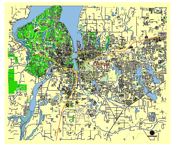
Principal streets and roads, names places, residential streets and roads, road number labels, water objects, land use areas.
Olympia Washington US vector map svg free
DOWNLOAD ARCHIVE FOR FREE >>>
Distributed with Creative Commons CC-Zero = Creative Commons CC0 1.0 Universal Public Domain Dedication International License
SEE ALSO FULL VERSION OF THE Olympia Washington US vector map (Adobe Illustrator, PDF etc.)
Olympia, the capital city of Washington State, has several principal streets, roads, and city districts that are significant for its geography and urban layout. Here’s an overview:
Principal Streets and Roads:
- Capitol Way: This is one of the main thoroughfares in downtown Olympia, running north-south through the city center. It connects the State Capitol Campus to various parts of the city.
- 4th Avenue: A major east-west street in downtown Olympia, known for its shops, restaurants, and businesses. It becomes Pacific Avenue as it continues eastward.
- State Avenue: Runs parallel to 4th Avenue and serves as another key commercial street in the downtown area.
- Martin Way: A significant arterial road that extends from Olympia into the neighboring cities of Lacey and Tumwater. It’s a primary route for accessing various residential and commercial areas.
- Pacific Avenue: An extension of 4th Avenue, it’s a main route through the eastern parts of Olympia, connecting to Lacey.
- Boulevard Road: A major north-south route running through the southeast part of Olympia, connecting residential areas to the downtown.
- Black Lake Boulevard: A major road that runs southwest of downtown Olympia, providing access to residential and commercial areas, as well as Black Lake itself.
- Harrison Avenue: This road runs through the west side of Olympia and is an important commercial corridor.
- Evergreen Parkway: This road serves the Evergreen State College and connects it to the main parts of Olympia and neighboring areas.
City Districts:
- Downtown Olympia: The heart of the city, featuring government buildings, businesses, cultural sites, and the historic waterfront area.
- Eastside: A residential district known for its older homes and proximity to the downtown core. It has a mix of parks, schools, and small businesses.
- Westside: Another major residential area that includes retail centers, parks, and schools. It’s also home to the Capital Mall, a significant shopping destination.
- South Capitol: Located just south of the Capitol Campus, this historic district features older homes and tree-lined streets. It’s a desirable residential area due to its proximity to downtown and the Capitol.
- North East Neighborhood: A growing residential area that includes a mix of newer developments and older neighborhoods. It provides a quieter, suburban feel while being close to city amenities.
- South Westside: Known for its suburban character and newer residential developments. It also includes some commercial areas and parks.
- Capitol Campus: The area encompassing the Washington State Capitol and surrounding government buildings. It’s a focal point for the city and state government activities.
- Tumwater: Although technically a separate city, Tumwater is often considered part of the greater Olympia area. It is located to the south and includes a mix of residential, commercial, and industrial areas.
- Lacey: Another nearby city often associated with Olympia. Lacey is to the east and is known for its rapid growth, suburban developments, and numerous parks and recreational areas.
These streets, roads, and districts form the backbone of Olympia, making it a vibrant and dynamic capital city with a blend of government, commerce, and residential life.
 Author: Kirill Shrayber, Ph.D. FRGS