Editable Vector Map of the Mountain View California US in SVG format.
Can be edited in the following programs: Adobe Illustrator, CorelDraw, InkScape
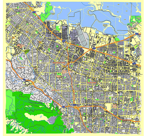
Principal streets and roads, names places, residential streets and roads, road number labels, water objects, land use areas.
Mountain View California US vector map svg free
DOWNLOAD ARCHIVE FOR FREE >>>
Distributed with Creative Commons Attribution 4.0 International License
SEE ALSO FULL VERSION OF THE Mountain View California US vector map (Adobe Illustrator, PDF etc.)
Mountain View, California, is a vibrant city located in the heart of Silicon Valley. Here are some of the principal streets, roads, and city districts:
Principal Streets and Roads
- El Camino Real (State Route 82):
- A major thoroughfare running through Mountain View, connecting it to neighboring cities like Palo Alto and Sunnyvale. It is lined with shops, restaurants, and businesses.
- Castro Street:
- The main street in downtown Mountain View, known for its lively atmosphere, diverse dining options, and retail shops. It is a popular spot for locals and visitors alike.
- Shoreline Boulevard:
- This road leads to Shoreline Park and Shoreline Amphitheatre, a major outdoor concert venue. It is also home to several corporate campuses, including Google.
- Middlefield Road:
- A significant north-south route that passes through residential neighborhoods and industrial areas. It connects to various local roads and highways.
- San Antonio Road:
- Connecting to Palo Alto, this road runs through the eastern part of Mountain View, providing access to shopping centers and residential areas.
- Rengstorff Avenue:
- Another major north-south road that intersects with El Camino Real and leads to Shoreline Park. It is surrounded by residential and commercial areas.
- Moffett Boulevard:
- This street provides access to the NASA Ames Research Center and Moffett Federal Airfield. It also connects to downtown Mountain View.
City Districts
- Downtown Mountain View:
- The heart of the city, centered around Castro Street. It features a mix of restaurants, shops, entertainment venues, and the Mountain View Center for the Performing Arts.
- Shoreline District:
- Located near Shoreline Boulevard, this district includes Shoreline Park, Shoreline Amphitheatre, Google’s main campus, and various tech companies.
- Monta Loma:
- A residential neighborhood characterized by mid-century modern homes. It is located in the northeastern part of the city.
- Rex Manor:
- A residential area known for its quiet streets and family-friendly atmosphere. It is situated west of Middlefield Road.
- The Crossings:
- A planned community with a mix of townhomes, condominiums, and single-family homes. It is located near the San Antonio shopping center.
- Old Mountain View:
- This historic district features older homes and tree-lined streets, close to downtown Mountain View. It is known for its charming and eclectic architectural styles.
- Waverly Park:
- A residential neighborhood in the southwestern part of Mountain View, known for its spacious homes and proximity to good schools.
- North Bayshore:
- An area primarily used for commercial and industrial purposes, home to many high-tech companies, including the Googleplex.
Notable Landmarks
- Computer History Museum:
- Located on Shoreline Boulevard, this museum showcases the history of computing and technology.
- Shoreline Park:
- A large regional park with a lake, golf course, and trails, offering recreational activities for the community.
- Stevens Creek Trail:
- A scenic trail that runs through Mountain View, providing a green space for walking, biking, and enjoying nature.
Understanding these streets, roads, and districts provides a comprehensive overview of Mountain View’s layout and highlights the city’s blend of residential, commercial, and recreational areas.
 Author: Kirill Shrayber, Ph.D. FRGS