Editable Vector Map of the Montpelier Vermont US in SVG format.
Can be edited in the following programs: Adobe Illustrator, CorelDraw, InkScape
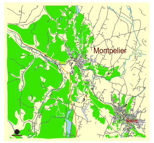
Principal streets and roads, names places, residential streets and roads, road number labels, water objects, land use areas.
Montpelier Vermont US vector map svg free
DOWNLOAD ARCHIVE FOR FREE >>>
Distributed with Creative Commons Attribution 4.0 International License
SEE ALSO FULL VERSION OF THE Montpelier Vermont US vector map (Adobe Illustrator, PDF etc.)
Montpelier, the capital of Vermont, is a charming city with a rich history and a well-preserved architectural heritage. Here are some of the principal streets, roads, and city districts in Montpelier:
Principal Streets and Roads
- State Street: A central thoroughfare that runs through downtown Montpelier, home to the Vermont State House and many government buildings.
- Main Street: Another key street in the downtown area, lined with shops, restaurants, and historic buildings.
- Elm Street: Running parallel to Main Street, Elm Street is a residential and commercial street with several important landmarks.
- Memorial Drive: This major road serves as a connector between downtown Montpelier and the surrounding areas, including the entrance to Interstate 89.
- Berlin Street: A primary route that extends from Montpelier into the neighboring town of Berlin, featuring a mix of residential and commercial properties.
- Barre Street: This street extends southeast from downtown, providing access to various neighborhoods and the nearby town of Barre.
City Districts
- Downtown Montpelier: The heart of the city, featuring a vibrant mix of businesses, cultural institutions, and historic architecture. It’s the hub of government activity with the State House and numerous state offices.
- Capitol Complex: Surrounding the Vermont State House, this district includes many government buildings and public spaces.
- Meadow Neighborhood: Located to the north of downtown, this residential area is known for its quiet streets and community atmosphere.
- Towne Hill: An affluent residential area situated on a hill overlooking the city, offering scenic views and upscale homes.
- College Hill: Home to the New England Culinary Institute and several educational institutions, this area has a mix of student housing and residential properties.
- Sabin’s Pasture: A semi-rural area known for its open spaces and development potential, situated to the east of downtown.
- Barre Street Neighborhood: A diverse area with a mix of residential and commercial properties, stretching along Barre Street and connecting to the town of Barre.
- Berlin Hill: Located to the south, this area features residential neighborhoods and is close to the regional Central Vermont Medical Center.
Montpelier’s layout, with its mix of historic charm and modern amenities, makes it a unique and vibrant small city.
 Author: Kirill Shrayber, Ph.D. FRGS