Editable Vector Map of the Menlo Park California US in SVG format.
Can be edited in the following programs: Adobe Illustrator, CorelDraw, InkScape
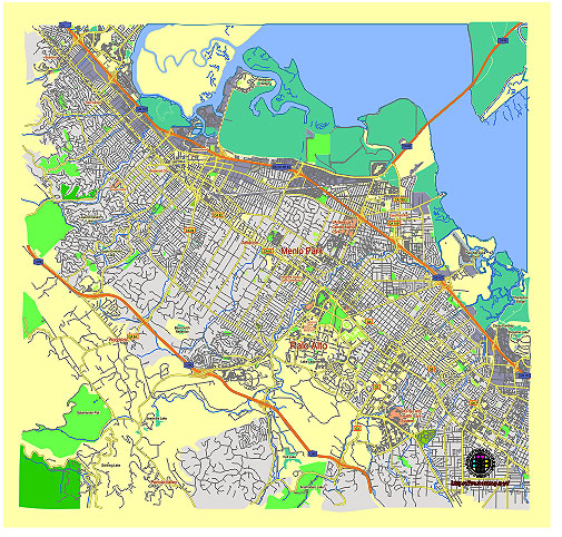
Principal streets and roads, names places, residential streets and roads, road number labels, water objects, land use areas.
Menlo Park California US editable vector map svg free
DOWNLOAD ARCHIVE FOR FREE >>>
Distributed with Creative Commons Attribution 4.0 International License
SEE ALSO FULL VERSION OF THE Menlo Park California US vector map (Adobe Illustrator, PDF etc.)
Menlo Park, California, is a city located in the San Francisco Bay Area, in San Mateo County. It is known for its affluence, proximity to Stanford University, and as part of the Silicon Valley. Here are some principal streets, roads, and city districts within Menlo Park:
Principal Streets and Roads:
- El Camino Real (State Route 82): This major thoroughfare runs north-south and is a primary route through Menlo Park, connecting it to other cities in the Bay Area.
- Sand Hill Road: Known for its concentration of venture capital firms, Sand Hill Road is a significant street in Menlo Park, especially for the tech industry.
- Willow Road (State Route 114): Running east-west, Willow Road connects Menlo Park to the Dumbarton Bridge, providing access to the East Bay.
- Middlefield Road: This road runs parallel to El Camino Real and is another important north-south route in the city.
- Ravenswood Avenue: Connecting El Camino Real with the Menlo Park Caltrain Station, Ravenswood Avenue is a key east-west route.
- University Avenue: Extending from East Palo Alto into Menlo Park, this road is significant for local traffic.
- Santa Cruz Avenue: This street runs through the downtown area and is known for its shops, restaurants, and local businesses.
City Districts and Neighborhoods:
- Downtown Menlo Park: Centered around Santa Cruz Avenue, this area is known for its vibrant commercial activity, including shops, restaurants, and cafes.
- Allied Arts: A residential neighborhood close to downtown, known for its historic district and the Allied Arts Guild.
- Sharon Heights: Located in the western part of Menlo Park, this affluent residential area is known for its hills, Sharon Heights Golf & Country Club, and proximity to Stanford.
- Suburban Park: A residential neighborhood in the eastern part of Menlo Park, known for its quiet streets and community feel.
- The Willows: Located to the southeast of Menlo Park, The Willows is a family-friendly neighborhood with a mix of homes and parks.
- Linfield Oaks: Adjacent to Burgess Park, this residential area is close to downtown and has a mix of homes, townhouses, and apartments.
- Belle Haven: Situated in the northeastern part of Menlo Park, Belle Haven is a diverse neighborhood with residential and commercial areas, including the Facebook headquarters (Meta Platforms).
- Felton Gables: A small, upscale neighborhood adjacent to Holbrook-Palmer Park, known for its beautiful homes and serene environment.
- Stanford Hills: An area located near the Stanford Linear Accelerator Center (SLAC) and known for its high-end residences and scenic views.
Landmarks and Notable Locations:
- Facebook (Meta Platforms) Headquarters: Located in the Belle Haven neighborhood, this is one of the most prominent landmarks in Menlo Park.
- Stanford Shopping Center: Although technically in Palo Alto, it is very close to Menlo Park and a major shopping destination for residents.
- Burgess Park: A central community park offering recreational facilities, including pools, sports fields, and the Menlo Park Library.
- Menlo Park Caltrain Station: A key transportation hub providing commuter rail services to San Francisco and San Jose.
Menlo Park’s layout reflects a blend of residential neighborhoods, commercial areas, and significant business districts, particularly influenced by its role in Silicon Valley.
 Author: Kirill Shrayber, Ph.D. FRGS