Editable Vector Map of the Memphis Tennessee US in SVG format.
Can be edited in the following programs: Adobe Illustrator, CorelDraw, InkScape
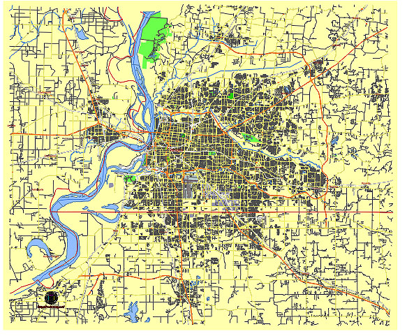
Principal streets and roads, names places, residential streets and roads, road number labels, water objects, land use areas.
Memphis Tennessee US editable vector map svg free
DOWNLOAD ARCHIVE FOR FREE >>>
Distributed with Creative Commons Attribution 4.0 International License
SEE ALSO FULL VERSION OF THE Memphis Tennessee US vector map (Adobe Illustrator, PDF etc.)
Memphis, Tennessee, is a vibrant city with a rich history and numerous significant streets, roads, and districts. Here’s an overview of some of the principal ones:
Principal Streets and Roads
- Beale Street
- Famous for its lively music scene and historic significance in the development of blues music.
- Poplar Avenue
- One of the major east-west thoroughfares in Memphis, connecting downtown to the eastern suburbs.
- Union Avenue
- Another key east-west route, running parallel to Poplar Avenue and leading to various important locations in the city.
- Lamar Avenue
- Part of U.S. Route 78, a major commercial route leading to and from the city.
- Elvis Presley Boulevard
- Named in honor of the King of Rock ‘n’ Roll, this street leads to Graceland, Elvis Presley’s former home.
- Germantown Parkway
- A major north-south road serving the eastern suburbs, particularly the city of Germantown.
- Interstate 40 (I-40)
- A major interstate highway that runs east-west through the northern part of Memphis.
- Interstate 55 (I-55)
- Another significant interstate, running north-south, connecting Memphis to Mississippi and beyond.
- Interstate 240 (I-240)
- An interstate beltway that loops around the city, providing access to various neighborhoods and other highways.
City Districts
- Downtown Memphis
- The central business district, home to attractions such as Beale Street, the National Civil Rights Museum, and the FedExForum.
- Midtown
- Known for its historic neighborhoods, vibrant arts scene, and cultural attractions like Overton Park and the Memphis Zoo.
- East Memphis
- A more residential and commercial area with shopping centers, offices, and upscale neighborhoods.
- South Memphis
- Historically significant and culturally rich, home to the Stax Museum of American Soul Music.
- North Memphis
- A diverse area with a mix of residential, industrial, and commercial zones.
- Germantown
- A suburban city east of Memphis known for its affluent communities and excellent schools.
- Bartlett
- Another suburban city to the northeast, characterized by family-friendly neighborhoods and parks.
- Orange Mound
- One of the oldest African-American communities in the United States, with a deep cultural and historical significance.
- Cooper-Young
- A trendy neighborhood in Midtown known for its eclectic mix of restaurants, bars, and shops.
- Harbor Town
- A planned community on Mud Island in the Mississippi River, featuring a mix of residential and commercial developments.
These streets, roads, and districts together form the complex and dynamic urban fabric of Memphis, each contributing its unique character to the city’s overall identity.
 Author: Kirill Shrayber, Ph.D. FRGS