Editable Vector Map of the Mashhad Iran in SVG format.
Can be edited in the following programs: Adobe Illustrator, CorelDraw, InkScape
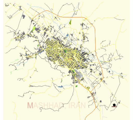
Principal streets and roads, names places, residential streets and roads, road number labels, water objects, land use areas.
Mashhad Iran editable vector map svg free
DOWNLOAD ARCHIVE FOR FREE >>>
Distributed with Creative Commons Attribution 4.0 International License
SEE ALSO FULL VERSION OF THE Mashhad Iran vector map (Adobe Illustrator, PDF etc.)
Mashhad, one of the largest cities in Iran and the capital of Razavi Khorasan Province, is a significant cultural and religious center, known for the shrine of Imam Reza, the eighth Shia Imam. Here are some principal streets, roads, and city districts of Mashhad:
Principal Streets and Roads
- Imam Reza Boulevard:
- A major thoroughfare leading directly to the Imam Reza Shrine, the most significant landmark in Mashhad. This boulevard is bustling with pilgrims and tourists.
- Vakilabad Boulevard:
- An important road in the western part of the city, connecting the city center to various neighborhoods and recreational areas, including Vakilabad Forest Park and the zoo.
- Ferdowsi Boulevard:
- A key commercial street with numerous shops, malls, and business centers. It’s named after the famous Persian poet Ferdowsi.
- Pardis Boulevard:
- Known for its modern residential complexes and proximity to some of the city’s parks and recreational facilities.
- Khayyam Boulevard:
- Another major road with commercial centers and access to different residential neighborhoods.
- Sajad Boulevard:
- This boulevard is lined with many educational institutions, office buildings, and parks.
- Tabarsi Street:
- Close to the Imam Reza Shrine, this street is filled with hotels, bazaars, and shops catering to pilgrims.
- Ahmadabad Street:
- A significant commercial and residential area with various shops, cafes, and businesses.
Principal City Districts
- District 1 (Central District):
- This district includes the Imam Reza Shrine and is the heart of Mashhad, with a mix of religious, commercial, and cultural sites.
- Sajad District:
- Known for its relatively upscale residential areas, parks, and modern amenities.
- Tabarsi District:
- Close to the central district, it is heavily influenced by the presence of the Imam Reza Shrine and includes many hotels and bazaars.
- Shahrak-e Gharb (West Town):
- A modern district with new residential developments and various commercial establishments.
- Khajeh Rabi’ District:
- Named after the Khajeh Rabi’ Mausoleum, this district has historical significance and is a mix of residential and commercial areas.
- Vakilabad District:
- A popular residential area with various recreational facilities, including parks and the Mashhad Zoo.
- Elahieh District:
- Another modern residential area known for its new housing developments and amenities.
- Pardis District:
- Features a mix of residential complexes and commercial areas, catering to middle and upper-middle-class residents.
- Farhangian District:
- A residential area known for its proximity to educational institutions and cultural centers.
- Sadra District:
- A developing area with new residential projects and infrastructure improvements.
These streets, roads, and districts contribute to the vibrant and diverse urban landscape of Mashhad, catering to both its residents and the millions of visitors who come to the city each year.
 Author: Kirill Shrayber, Ph.D. FRGS