Editable Vector Map of the Macon Georgia US in SVG format.
Can be edited in the following programs: Adobe Illustrator, CorelDraw, InkScape
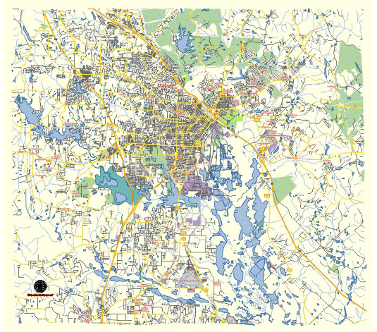
Principal streets and roads, names places, residential streets and roads, road number labels, water objects, land use areas.
Macon Georgia US editable vector map svg free
DOWNLOAD ARCHIVE FOR FREE >>>
Distributed with Creative Commons Attribution 4.0 International License
SEE ALSO FULL VERSION OF THE Macon Georgia US vector map (Adobe Illustrator, PDF etc.)
Macon, Georgia, located in central Georgia, is a city rich in history and culture. Here are some of the principal streets, roads, and city districts of Macon:
Principal Streets and Roads:
- Riverside Drive: One of the main thoroughfares in Macon, providing access to several residential neighborhoods and commercial areas.
- Vineville Avenue: A significant street that runs through historic neighborhoods and connects to downtown.
- Pio Nono Avenue: A major road that intersects several key areas, including shopping centers and residential districts.
- Gray Highway: This road connects Macon to Gray, Georgia, and serves as an important route for commuters.
- Eisenhower Parkway: A major commercial corridor with shopping centers, restaurants, and business establishments.
- Mercer University Drive: Named after Mercer University, this street runs near the university campus and provides access to various student housing and amenities.
- Forsyth Street: Running through downtown, Forsyth Street is home to many historic buildings, shops, and restaurants.
- Martin Luther King Jr. Boulevard: An important street that intersects with many other major roads and runs through downtown Macon.
City Districts:
- Downtown Macon: The heart of the city, featuring historic buildings, government offices, cultural institutions, and a variety of dining and entertainment options.
- Ingleside Village: A charming neighborhood known for its eclectic shops, cafes, and historic homes.
- Historic Vineville: A district with beautiful historic homes and tree-lined streets, offering a glimpse into Macon’s past.
- College Hill Corridor: An area near Mercer University that has seen revitalization efforts, featuring student housing, local businesses, and community events.
- North Macon: A suburban area with newer residential developments, shopping centers, and schools.
- East Macon: A diverse area with a mix of residential, commercial, and industrial zones.
- South Macon: Known for its residential neighborhoods and proximity to major highways and industrial areas.
- Pleasant Hill: A historic African American neighborhood with a rich cultural heritage and community spirit.
- Napier Heights: A neighborhood with historic significance, currently undergoing revitalization efforts.
- Bloomfield: A residential area with a mix of single-family homes and apartment complexes.
These streets and districts represent a cross-section of Macon’s diverse urban landscape, highlighting its historic roots and modern developments.
 Author: Kirill Shrayber, Ph.D. FRGS