Editable Vector Map of the Lille France in SVG format.
Can be edited in the following programs: Adobe Illustrator, CorelDraw, InkScape
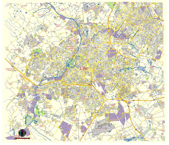
Principal streets and roads, names places, residential streets and roads, road number labels, water objects, land use areas.
Lille France editable vector map svg free
DOWNLOAD ARCHIVE FOR FREE >>>
Distributed with Creative Commons Attribution 4.0 International License
SEE ALSO FULL VERSION OF THE Lille France vector map (Adobe Illustrator, PDF etc.)
Lille, a vibrant city in northern France, is known for its rich history, beautiful architecture, and lively cultural scene. Here are some of the principal streets, roads, and city districts in Lille:
Principal Streets and Roads
- Rue Faidherbe: A central street that connects the Lille-Flandres train station to the Grand Place, lined with shops and historic buildings.
- Rue de Béthune: A bustling pedestrian street known for its numerous shops, cafes, and the UGC Cine-Cité cinema.
- Boulevard de la Liberté: A major thoroughfare that runs through the heart of the city, linking the Place de la République with the Lille Europe district.
- Rue Esquermoise: A historic street that leads to the Old Stock Exchange and the Grand Place, famous for its traditional architecture and boutique stores.
- Avenue du Peuple Belge: Runs along the canal and is known for its scenic views and proximity to the Hospice Comtesse Museum.
- Rue Royale: Another significant street in the Vieux-Lille (Old Lille) area, known for its historic charm and numerous restaurants.
- Rue de Paris: An important street that extends from the city center, passing the Palais des Beaux-Arts and leading towards the east.
- Boulevard Carnot: A major boulevard that connects the city center with the northern parts of Lille, leading towards the Citadel and the Bois de Boulogne park.
Principal City Districts
- Vieux-Lille (Old Lille): The historic heart of Lille, characterized by its narrow cobblestone streets, Flemish-style buildings, and vibrant nightlife. Key attractions include the Old Stock Exchange, Notre Dame de la Treille Cathedral, and Hospice Comtesse Museum.
- Centre Ville (City Center): The bustling downtown area around the Grand Place (Place du Général de Gaulle), filled with shops, restaurants, and landmarks such as the Opera House and the Chamber of Commerce.
- Wazemmes: A lively and multicultural district known for its bustling market (Marché de Wazemmes), diverse food offerings, and vibrant atmosphere.
- Euralille: A modern business district developed in the 1990s, home to the Lille Europe and Lille Flandres train stations, the Euralille shopping center, and numerous office buildings.
- Lille-Sud: A large residential area with a mix of housing types, community centers, and green spaces.
- Vauban-Esquermes: A district known for its student population, due to the proximity of Université Catholique de Lille, as well as the scenic Citadel park and Zoo.
- Saint-Maurice Pellevoisin: A primarily residential neighborhood with good transport links and proximity to the city center.
- Moulins: A district undergoing significant regeneration, featuring a mix of historic industrial buildings and new developments, as well as cultural venues like La Gare Saint Sauveur.
- Fives: Known for its industrial heritage, this district is experiencing revitalization and has a growing arts scene, with venues like Le 188 offering cultural events.
Lille’s blend of historic charm and modern dynamism makes exploring its streets and districts a rewarding experience for visitors and locals alike.
 Author: Kirill Shrayber, Ph.D. FRGS