Editable Vector Map of the Laval Canada in SVG format.
Can be edited in the following programs: Adobe Illustrator, CorelDraw, InkScape
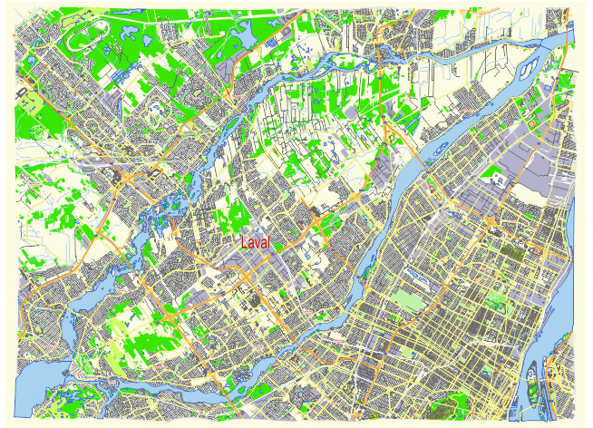
Principal streets and roads, names places, residential streets and roads, road number labels, water objects, land use areas.
Laval Canada editable vector map svg free
DOWNLOAD ARCHIVE FOR FREE >>>
Distributed with Creative Commons Attribution 4.0 International License
SEE ALSO FULL VERSION OF THE Laval Canada vector map (Adobe Illustrator, PDF etc.)
Laval, located in the province of Quebec, Canada, is a vibrant city with a well-organized network of streets, roads, and distinct districts. Here are the principal streets, roads, and city districts of Laval:
Principal Streets and Roads
- Boulevard des Laurentides: This major north-south artery runs through several districts and is one of the main commercial streets in Laval.
- Boulevard Saint-Martin: An important east-west boulevard that crosses the central part of Laval, providing access to various neighborhoods and commercial areas.
- Autoroute 15 (Laurentian Autoroute): A major north-south highway that runs through Laval, connecting it to Montreal and the northern suburbs.
- Autoroute 440 (Jean-Noël Lavoie Autoroute): An important east-west highway that crosses the city, facilitating access to various parts of Laval and neighboring regions.
- Boulevard de la Concorde: Another key east-west thoroughfare in Laval, known for its commercial and residential areas.
- Boulevard Curé-Labelle: A significant north-south route that serves as a commercial hub with various businesses and services along its stretch.
- Boulevard Cartier: This boulevard is important for local traffic and connects several residential neighborhoods.
- Boulevard Le Corbusier: Known for its industrial and commercial zones, this boulevard is crucial for businesses in Laval.
City Districts
- Chomedey: One of the most populous and diverse districts in Laval, Chomedey is known for its vibrant community, shopping centers, and cultural diversity.
- Pont-Viau: Located near the bridge to Montreal, this district is a mix of residential and commercial areas, offering easy access to the neighboring city.
- Laval-des-Rapides: A densely populated area with a mix of residential buildings, parks, and educational institutions.
- Sainte-Dorothée: Known for its suburban feel, Sainte-Dorothée offers a mix of residential areas and green spaces.
- Fabreville: A primarily residential district with a suburban character, featuring parks and local businesses.
- Vimont: This district combines residential zones with commercial and recreational facilities.
- Sainte-Rose: Known for its historic charm, Sainte-Rose features quaint streets, local shops, and a strong sense of community.
- Duvernay: A mix of residential and commercial areas, Duvernay is also known for its green spaces and recreational facilities.
- Auteuil: Primarily a residential district, Auteuil offers a suburban lifestyle with access to parks and local amenities.
- Saint-François: A district with a blend of residential and rural areas, providing a quieter, more laid-back atmosphere.
- Saint-Vincent-de-Paul: Known for its historic sites and residential neighborhoods, this district combines charm with modern conveniences.
These principal streets, roads, and districts form the backbone of Laval’s urban structure, contributing to its accessibility, economic activity, and community life.
 Author: Kirill Shrayber, Ph.D. FRGS