Editable Vector Map of the Kyoto Japan in SVG format.
Can be edited in the following programs: Adobe Illustrator, CorelDraw, InkScape
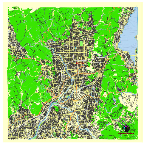
Principal streets and roads, names places, residential streets and roads, road number labels, water objects, land use areas.
Kyoto Japan editable vector map svg free
DOWNLOAD ARCHIVE FOR FREE >>>
Distributed with Creative Commons Attribution 4.0 International License
SEE ALSO FULL VERSION OF THE Kyoto Japan vector map (Adobe Illustrator, PDF etc.)
Kyoto, Japan, is a city rich in history and culture, with a well-organized layout that includes numerous significant streets, roads, and districts. Here are some of the principal streets, roads, and city districts of Kyoto:
Principal Streets and Roads
- Shijo Street (Shijo-dori):
- One of the main commercial streets in Kyoto, running east-west through the city. It’s known for its shopping, dining, and entertainment options, especially in the Gion and Kawaramachi areas.
- Kawaramachi Street (Kawaramachi-dori):
- A major north-south street that intersects Shijo Street. It is a bustling area with many shops, restaurants, and department stores.
- Karasuma Street (Karasuma-dori):
- Runs north-south through the city center and is a significant business district. It intersects with Shijo Street at Shijo Karasuma, a key commercial area.
- Higashioji Street (Higashioji-dori):
- A major road that runs along the eastern side of the city, providing access to many of Kyoto’s famous temples and shrines.
- Sanjō Street (Sanjo-dori):
- Another important east-west street known for its historic and cultural significance. The Sanjo Bridge marks the end of the ancient Tokaido Road from Tokyo.
- Gojo Street (Gojo-dori):
- Extends east-west and is known for its historic significance and various traditional shops and workshops.
- Marutamachi Street (Marutamachi-dori):
- Runs east-west through the northern part of the city center, passing by the Kyoto Imperial Palace.
Notable Districts
- Gion District:
- Kyoto’s most famous geisha district, known for its traditional wooden machiya houses, tea houses, and the iconic Hanamikoji Street.
- Higashiyama District:
- A historic district to the east of the Kamo River, filled with preserved streets, traditional shops, temples, and shrines such as Kiyomizu-dera and Yasaka Shrine.
- Arashiyama:
- Located in the western part of Kyoto, known for its scenic beauty, bamboo groves, and the iconic Togetsukyo Bridge.
- Pontocho District:
- A narrow alley running parallel to the Kamo River, known for its traditional restaurants and nightlife.
- Fushimi District:
- Located in the southeastern part of Kyoto, famous for the Fushimi Inari Taisha Shrine and its thousands of torii gates, as well as for its sake breweries.
- Nishijin District:
- Known for its traditional textile industry, particularly Nishijin weaving, with many small workshops and historic buildings.
- Kinkakuji and Kitano District:
- Located in the northwest part of Kyoto, home to the famous Golden Pavilion (Kinkaku-ji) and Kitano Tenmangu Shrine.
- Sakyo District:
- Includes the northern and eastern parts of Kyoto, home to various temples, Kyoto University, and the famous Philosopher’s Path.
These streets and districts reflect Kyoto’s rich history and vibrant contemporary culture, offering a blend of traditional and modern experiences.
 Author: Kirill Shrayber, Ph.D. FRGS