Editable Vector Map of the Kelowna Canada in SVG format.
Can be edited in the following programs: Adobe Illustrator, CorelDraw, InkScape
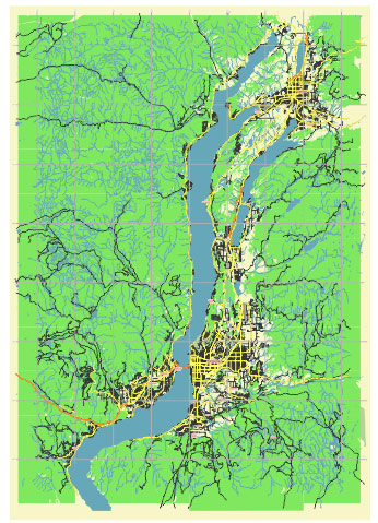
Principal streets and roads, names places, residential streets and roads, road number labels, water objects, land use areas.
Kelowna Canada editable vector map svg free
DOWNLOAD ARCHIVE FOR FREE >>>
Distributed with Creative Commons Attribution 4.0 International License
SEE ALSO FULL VERSION OF THE Kelowna Canada vector map (Adobe Illustrator, PDF etc.)
Kelowna, located in the Okanagan Valley of British Columbia, Canada, is known for its stunning landscapes, wineries, and outdoor recreational activities. Here are some of the principal streets, roads, and districts in Kelowna:
- Downtown Kelowna: This is the heart of the city, featuring Bernard Avenue and the waterfront area along Okanagan Lake. It’s home to numerous shops, restaurants, cafes, and cultural attractions.
- Bernard Avenue: One of the main streets in downtown Kelowna, Bernard Avenue is lined with shops, boutiques, galleries, and eateries. It’s a bustling hub of activity, especially during the summer months.
- Waterfront Park: Located along Okanagan Lake, Waterfront Park offers beautiful views of the lake and surrounding mountains. It’s a popular spot for picnics, walks, and events.
- Pandosy Village: This vibrant neighborhood is known for its eclectic mix of shops, restaurants, and cafes. It has a laid-back, bohemian vibe and is popular with locals and tourists alike.
- Gordon Drive: Running through various neighborhoods, Gordon Drive is a major thoroughfare in Kelowna, connecting downtown with the southern suburbs.
- Mission District: Situated along the shores of Okanagan Lake, the Mission District is known for its upscale homes, beaches, and parks. It’s a desirable residential area with a relaxed atmosphere.
- Rutland: Located in the northeastern part of Kelowna, Rutland is a diverse and vibrant community with a mix of residential, commercial, and industrial areas. It’s home to parks, schools, and shopping centers.
- Glenmore: Situated to the north of downtown Kelowna, Glenmore is a family-friendly neighborhood with parks, schools, and recreational facilities. It’s a popular area for both young professionals and families.
- Enterprise Way: This commercial corridor is home to numerous businesses, offices, and industrial parks. It’s a bustling area with easy access to major transportation routes.
- Harvey Avenue (Highway 97): As one of the main highways running through Kelowna, Harvey Avenue is a major transportation route connecting the city with other parts of the Okanagan Valley.
These are just a few of the principal streets, roads, and districts in Kelowna. The city has much more to explore, including its scenic parks, wineries, and outdoor recreational areas.
 Author: Kirill Shrayber, Ph.D. FRGS