Editable Vector Map of the Istanbul Turkey in SVG format.
Can be edited in the following programs: Adobe Illustrator, CorelDraw, InkScape
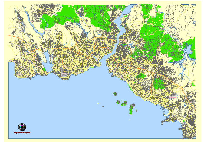
Principal streets and roads, names places, residential streets and roads, road number labels, water objects, land use areas.
Istanbul Turkey editable vector map svg free
DOWNLOAD ARCHIVE FOR FREE >>>
Distributed with Creative Commons Attribution 4.0 International License
SEE ALSO FULL VERSION OF THE Istanbul Turkey vector map (Adobe Illustrator, PDF etc.)
Istanbul is a vast and dynamic city, spanning two continents and boasting numerous districts, streets, and roads. Here’s an overview of some of the principal streets, roads, and city districts in Istanbul:
Districts:
- Fatih: Home to historical landmarks like the Hagia Sophia, Topkapi Palace, and the Grand Bazaar.
- Sultanahmet: Another historic area known for the Blue Mosque, Hagia Sophia, and Hippodrome.
- Beyoğlu: A lively district with Istiklal Avenue, Taksim Square, and Galata Tower.
- Kadıköy: Located on the Asian side, known for its vibrant atmosphere, Moda neighborhood, and Kadıköy Market.
- Üsküdar: A historic district with landmarks like Maiden’s Tower and Çamlıca Hill.
- Beşiktaş: Famous for Dolmabahçe Palace, Beşiktaş Square, and bustling Beşiktaş Bazaar.
Streets and Roads:
- İstiklal Avenue: A bustling pedestrian street in Beyoğlu with shops, restaurants, and historical buildings.
- Bosphorus Strait: Not a street per se, but this waterway is a significant part of Istanbul’s geography, with roads lining its shores.
- Bağdat Avenue: A major thoroughfare on the Asian side, known for its upscale shops and cafes.
- E-5 Highway: A major roadway running from European to Asian Istanbul, connecting many neighborhoods and districts.
- TEM Highway: Another important highway connecting different parts of the city, running parallel to the E-5.
- Karaköy Pier Road: A road along the Golden Horn, famous for its seafood restaurants and ferry terminals.
- Kennedy Avenue (formerly Büyükdere Avenue): A major road on the European side, passing through business districts like Levent and Maslak.
These are just a few examples of the many streets, roads, and districts that make up Istanbul. The city is vast and diverse, with each area offering its own unique atmosphere and attractions.
 Author: Kirill Shrayber, Ph.D. FRGS