Editable Vector Map of the Heathrow Airport London UK in SVG format.
Can be edited in the following programs: Adobe Illustrator, CorelDraw, InkScape
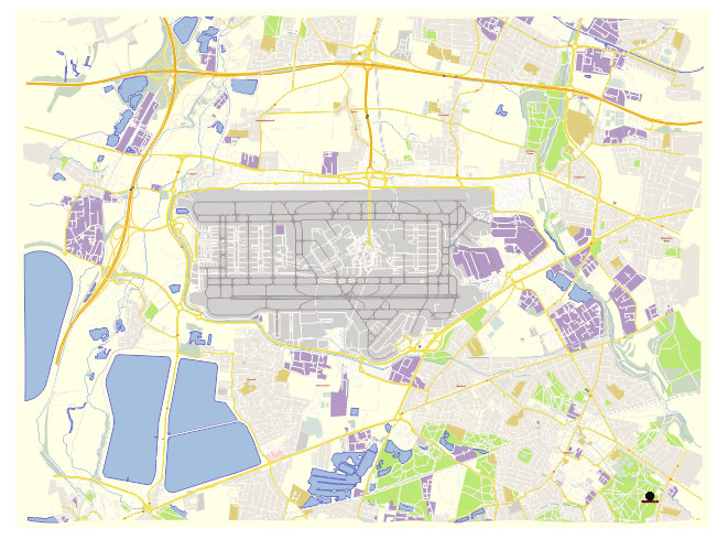
Principal streets and roads, names places, residential streets and roads, road number labels, water objects, land use areas.
Heatrow Airport London UK editable vector map svg free
DOWNLOAD ARCHIVE FOR FREE >>>
Distributed with Creative Commons Attribution 4.0 International License
SEE ALSO FULL VERSION OF THE Heathrow Airport London UK vector map (Adobe Illustrator, PDF etc.)
Heathrow Airport (LHR), located in London, UK, is one of the busiest airports in the world. Its infrastructure includes a variety of principal streets, roads, and buildings. Here’s an overview:
Principal Streets and Roads:
- Bath Road (A4): This is a major road running parallel to the northern perimeter of the airport. Many hotels and airport services are located along Bath Road.
- M4 Motorway: This motorway provides a direct route to Heathrow from Central London and other parts of the UK.
- M25 Motorway: Encircles London and connects with the M4, providing access to Heathrow from various directions.
- Great South West Road (A30): Runs along the southern perimeter of the airport.
- Airport Perimeter Road: Encircles the airport and provides access to various terminals, car parks, and cargo areas.
- Tunnel Road: This road leads directly into the central area of the airport and provides access to Terminals 2 and 3.
Principal Buildings and Terminals:
- Terminal 2 (The Queen’s Terminal):
- Function: Serves mainly Star Alliance airlines.
- Key Features: Modern design, extensive shopping, and dining options.
- Terminal 3:
- Function: Primarily serves long-haul flights for various airlines including Emirates, Virgin Atlantic, and others.
- Key Features: Dedicated Virgin Atlantic Clubhouse, numerous duty-free shops, and restaurants.
- Terminal 4:
- Function: Serves airlines from the SkyTeam alliance and others.
- Key Features: Recently refurbished, with a wide range of amenities and lounges.
- Terminal 5:
- Function: Exclusively serves British Airways and Iberia.
- Key Features: Modern facilities, a wide variety of shops and restaurants, and extensive British Airways lounges.
- Cargo Terminal:
- Function: Handles freight and logistics operations.
- Key Features: Multiple warehouses, customs facilities, and freight forwarding services.
- Control Tower:
- Function: Manages air traffic control for the airport.
- Key Features: One of the tallest structures at Heathrow, offering comprehensive visibility over the airfield.
- Maintenance Areas:
- Function: Provide maintenance, repair, and overhaul services for aircraft.
- Key Features: Extensive hangar facilities used by various airlines for aircraft servicing.
Additional Infrastructure:
- Car Parks: Numerous car parking facilities including short-stay, long-stay, business, and meet & greet options.
- Hotels: Various hotels are situated around the airport, including the Sofitel at Terminal 5, Hilton at Terminal 4, and numerous others along Bath Road.
- Transport Hubs: Heathrow is connected by the London Underground (Piccadilly Line), Heathrow Express (to Paddington Station), and various bus and coach services.
This comprehensive infrastructure supports the airport’s operations and facilitates the movement of millions of passengers and tons of cargo annually.
 Author: Kirill Shrayber, Ph.D. FRGS