Editable Vector Map of the Gisborne New Zealand in SVG format.
Can be edited in the following programs: Adobe Illustrator, CorelDraw, InkScape
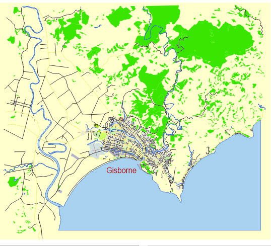
Principal streets and roads, names places, residential streets and roads, road number labels, water objects, land use areas.
Gisborne New Zealand editable vector map svg free
DOWNLOAD ARCHIVE FOR FREE >>>
Distributed with Creative Commons Attribution 4.0 International License
SEE ALSO FULL VERSION OF THE Gisborne New Zealand vector map (Adobe Illustrator, PDF etc.)
Gisborne, New Zealand, located on the east coast of the North Island, is known for its rich Maori culture, beautiful beaches, and as the first city in the world to see the sunrise each day. Here are the principal streets, roads, and city districts in Gisborne:
Principal Streets and Roads
- Gladstone Road:
- This is one of the main commercial streets in Gisborne, running through the central business district (CBD). It features a variety of shops, cafes, and businesses.
- Customhouse Street:
- This street runs parallel to the Taruheru River and is home to various restaurants, bars, and the popular Farmers’ Market on weekends.
- Wainui Road:
- Extending towards the suburb of Wainui, this road leads to the famous Wainui Beach, a popular spot for surfing and other beach activities.
- Awapuni Road:
- This road is important for access to residential areas and also leads to the Awapuni area and the Gisborne Airport.
- Peel Street:
- Another significant street in the CBD, intersecting with Gladstone Road and hosting a variety of retail outlets and services.
- Grey Street:
- Running through both commercial and residential zones, Grey Street is a key route within the city.
City Districts
- Central Business District (CBD):
- The heart of Gisborne, featuring a mix of retail shops, offices, restaurants, and entertainment venues. Key streets here include Gladstone Road and Peel Street.
- Kaiti:
- A predominantly residential area to the east of the CBD. It includes Kaiti Hill (Titirangi), which offers panoramic views of Gisborne and the surrounding area.
- Elgin:
- A residential suburb to the south of the CBD, characterized by family homes and local amenities.
- Riverdale:
- Located to the west of the CBD, Riverdale is a residential area with parks and schools.
- Mangapapa:
- Another residential district, situated north of the CBD. It has several schools and parks and is known for its community vibe.
- Te Hapara:
- Situated to the northwest of the CBD, this suburb features a mix of residential housing and local businesses. It’s one of the older suburbs in Gisborne.
- Wainui:
- This suburb is to the northeast of the CBD and is renowned for Wainui Beach. It’s a popular area for those looking to live near the coast.
- Awapuni:
- Located to the south of the city center, this area includes residential zones and the Gisborne Airport.
These streets, roads, and districts form the essential framework of Gisborne, contributing to its unique character and accessibility.
 Author: Kirill Shrayber, Ph.D. FRGS