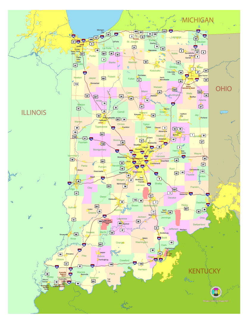
Free Vector map of the state of Indiana, USA, main roads with numbers, colored counties with names.
Free, royalty-free, unlimited use.
The map is intended for editing, media, presentations.
File format SVG, PDF and Adobe Illustrator, Simplified version
Map in layers, fully vector, editable.
See also: detailed vector map of the state of Indiana
Download vector map in archive:
https://vectormap.net/wp-content/uploads/free_maps_states_cities_2024/map_vector_us_state_indiana_free_simple_ai.ai.zip
https://vectormap.net/wp-content/uploads/free_maps_states_cities_2024/map_vector_us_state_indiana_free_simple_ai_pdf.pdf.zip
https://vectormap.net/wp-content/uploads/free_maps_states_cities_2024/map_vector_us_state_indiana_free_simple_ai_svg.svg.zip

Free Vector map of the state of Indiana, USA, main roads with numbers, colored counties with names.
Indiana is a state located in the Midwest region of the United States. It is bordered by Michigan to the north, Ohio to the east, Kentucky to the south, and Illinois to the west. Here’s a detailed geographic description of Indiana, including its major cities:
Geography
- Topography: Indiana’s landscape is a mix of flat plains and gently rolling hills. The northern part of the state, especially near Lake Michigan, is part of the Great Lakes Plain, while the central and southern regions are dominated by the Central Lowlands and the Cumberland Plateau, with small hills and river valleys.
- Rivers and Lakes: Indiana is crisscrossed by many rivers, including the Wabash River, which flows from the east to the west, and the Ohio River, which forms much of the southern border. The White River, Tippecanoe River, and Kankakee River are other significant waterways. The state also has several lakes, with Lake Michigan along the northwest border being the most prominent.
- Climate: Indiana experiences a humid continental climate, with hot summers and cold winters. The state’s weather is influenced by both the Great Lakes to the north and the broader Midwest climate zone.
Major Cities
- Indianapolis (Capital and Largest City)
- Located in central Indiana, Indianapolis is the state capital and the largest city in Indiana. It is a major hub for transportation, sports, and culture. The city is known for the Indianapolis 500, one of the most famous automobile races in the world. Indianapolis is also home to a rich cultural scene, with museums, theaters, and a downtown area full of restaurants and shopping options.
- Fort Wayne
- Situated in the northeastern part of the state, Fort Wayne is Indiana’s second-largest city. It is a regional center for industry, commerce, and education. Fort Wayne lies at the confluence of three rivers: the St. Joseph, St. Mary’s, and Maumee rivers.
- Evansville
- Located in the southwestern corner of the state, Evansville is Indiana’s third-largest city. It sits along the Ohio River and has a strong industrial base, particularly in the manufacturing and transportation sectors. The city is a regional hub for healthcare, education, and commerce.
- South Bend
- South Bend is in the northern part of the state, near the Michigan border. It is best known for being the home of Notre Dame University, a major center of education and sports. The city has a history tied to the manufacturing and automobile industries.
- Gary
- Located just east of Chicago along the southern shore of Lake Michigan, Gary is an important industrial city with a history rooted in steel production. It is part of the Chicago metropolitan area, which influences much of its economy and culture.
- Bloomington
- Bloomington is a city in southern Indiana and is best known as the home of Indiana University. It has a thriving arts and music scene and is located in a region of rolling hills, forests, and lakes.
- Carmel
- Carmel is a suburb of Indianapolis, located just to the north. Known for its high quality of life, excellent schools, and vibrant arts scene, Carmel is one of the fastest-growing cities in Indiana.
- Muncie
- Muncie is located in the central part of the state and is home to Ball State University. The city has a rich history in manufacturing and is now a college town with a focus on education and the arts.
- Lafayette
- Located in west-central Indiana, Lafayette is another city along the Wabash River. It is home to Purdue University in nearby West Lafayette, making it a key center for education, research, and technology.
- Terre Haute
- Situated in the western part of the state near the Illinois border, Terre Haute is a city known for its academic institutions, including Indiana State University, and its role in transportation and logistics.
Regions of Indiana
- Northern Indiana: This region is influenced by its proximity to Lake Michigan, which moderates the climate and influences the economy. The area is home to the cities of Gary, South Bend, and Fort Wayne. It has a mix of urban centers, industrial towns, and rural farmland.
- Central Indiana: Home to the state capital, Indianapolis, central Indiana is the economic and political heart of the state. This region features both suburban growth and rural communities, with a focus on manufacturing, technology, and services.
- Southern Indiana: Known for its rolling hills, forests, and limestone quarries, southern Indiana is less industrialized than the north but is known for its natural beauty and historical sites. Bloomington and Evansville are major cities in this region.
Transportation
Indiana has a well-developed transportation network with numerous highways, railroads, and airports connecting its major cities. Indianapolis International Airport is a major hub for air travel. The state also has access to important interstate highways, including Interstate 65, Interstate 69, Interstate 70, and Interstate 80/90, which connect Indiana to neighboring states and the broader region.
This combination of fertile land, rivers, lakes, and cities makes Indiana a significant state both geographically and economically in the Midwest.

 Author: Kirill Shrayber, Ph.D. FRGS