
France
Country in Europe See also: Full version maps of France
France is a country in Western Europe with medieval towns, alpine villages and Mediterranean beaches. Paris, the capital of the state, is famous for its fashion houses, the oldest art museums, including the Louvre, and landmarks such as the Eiffel Tower. France is known for its wines and fine cuisine. The rock paintings in the Lascaux cave, the amphitheater of the Three Gallias in Lyon and the huge Palace of Versailles testify to the rich history of these places.
Capital: Paris, see high detailed vector maps of the city
Area: 543,940 km²
Population: 67.39 million
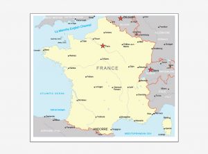
FREE MAP FRANCE VECTOR ADOBE ILLUSTRATOR Ver.1
Download link FREE map France Adobe Illustrator Ver.1
FREE MAP FRANCE VECTOR COREL DRAW Ver.1
Download link FREE map France Corel Draw Ver.1
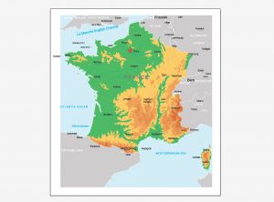
FREE MAP FRANCE VECTOR ADOBE ILLUSTRATOR Ver.2
Download link FREE map France Adobe Illustrator Ver.2
FREE MAP FRANCE VECTOR COREL DRAW Ver.2
Download link FREE map France Corel Draw Ver.2
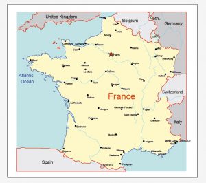
FREE MAP FRANCE VECTOR ADOBE ILLUSTRATOR Ver.3
Download link FREE map France Adobe Illustrator Ver.3
FREE MAP FRANCE VECTOR COREL DRAW Ver.3
Download link FREE map France Corel Draw Ver.3

 Author: Kirill Shrayber, Ph.D. FRGS