Editable Vector Map of the Edmonton Canada in SVG format.
Can be edited in the following programs: Adobe Illustrator, CorelDraw, InkScape
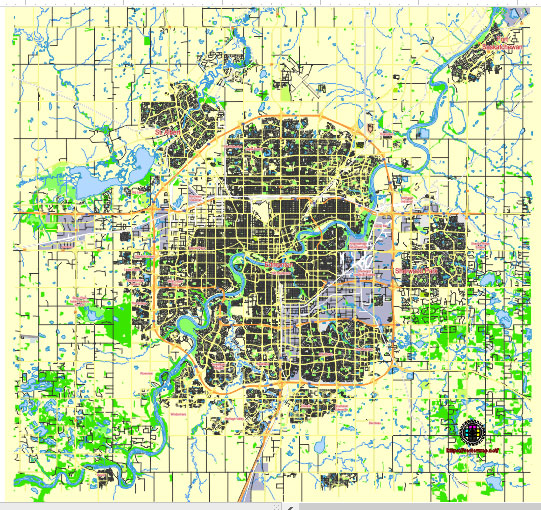
Principal streets and roads, names places, residential streets and roads, road number labels, water objects, land use areas.
Edmonton Canada editable vector map svg free
DOWNLOAD ARCHIVE FOR FREE >>>
Distributed with Creative Commons Attribution 4.0 International License
SEE ALSO FULL VERSION OF THE Edmonton Canada vector map (Adobe Illustrator, PDF etc.)
Edmonton, the capital of Alberta, Canada, is a city with a well-structured road network. Here are some of its principal streets, roads, and city districts:
- Jasper Avenue: This is one of the main streets in downtown Edmonton. It’s known for its shops, restaurants, and vibrant atmosphere.
- Whyte Avenue (82nd Avenue): Another vibrant street, especially popular with the younger crowd, known for its boutiques, restaurants, bars, and nightlife.
- Anthony Henday Drive (Henday Loop): This is Edmonton’s ring road, encircling the city. It provides access to various parts of the city and connects to major highways leading out of Edmonton.
- Gateway Boulevard: This road connects downtown Edmonton to the southern suburbs. It’s a major route for commuters.
- Calgary Trail (Gateway Boulevard/Highway 2): This is a significant route running through Edmonton, connecting it to the city of Calgary to the south.
- Stony Plain Road: It stretches westward from downtown and is a commercial and residential thoroughfare.
- Yellowhead Trail (Highway 16): This is a major east-west highway passing through Edmonton, connecting it to other parts of Alberta and Saskatchewan.
- University Avenue: Located near the University of Alberta campus, it’s a busy street with access to various university buildings and facilities.
- 124 Street: Known for its art galleries, boutiques, and restaurants, it’s a trendy area northwest of downtown.
- 104 Avenue: Another downtown street with commercial and residential areas, as well as access to the Ice District and Rogers Place arena.
Districts:
- Downtown: The central business district of Edmonton, characterized by skyscrapers, shops, restaurants, and cultural institutions.
- Old Strathcona: Located south of the North Saskatchewan River, it’s a historic district with a lively arts and entertainment scene.
- West Edmonton Mall: Not a street but a massive shopping and entertainment complex, it’s one of the largest malls in North America and a major tourist attraction.
- Glenora: An upscale residential neighborhood located west of downtown, known for its beautiful homes and tree-lined streets.
- River Valley: While not a district per se, the River Valley parks system is a defining feature of Edmonton, offering green space and recreational opportunities throughout the city.
These are just a few of the prominent streets, roads, and districts in Edmonton, but the city has many more neighborhoods and thoroughfares worth exploring.
 Author: Kirill Shrayber, Ph.D. FRGS