Editable Vector Map of the Dublin Ireland in SVG format.
Can be edited in the following programs: Adobe Illustrator, CorelDraw, InkScape
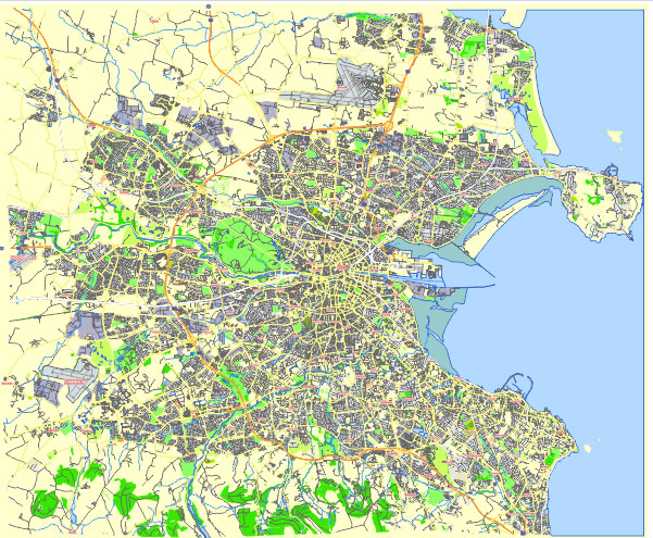
Principal streets and roads, names places, residential streets and roads, road number labels, water objects, land use areas.
Dublin Ireland editable vector map svg free
DOWNLOAD ARCHIVE FOR FREE >>>
Distributed with Creative Commons Attribution 4.0 International License
SEE ALSO FULL VERSION OF THE Dublin Ireland vector map (Adobe Illustrator, PDF etc.)
Dublin, the capital of Ireland, is a city with a rich history and diverse districts. Here is an overview of some of the principal streets, roads, and districts in Dublin:
Principal Streets and Roads
- O’Connell Street:
- One of the main thoroughfares in Dublin, known for its wide expanse and significant landmarks such as the Spire of Dublin and the General Post Office (GPO).
- Grafton Street:
- A famous shopping street in Dublin, pedestrianized and known for its street performers and high-end shops.
- Henry Street:
- Another key shopping street, located on the north side of the city, featuring many retail stores and the Ilac Shopping Centre.
- Dame Street:
- Runs through the city center, close to Trinity College and the Temple Bar district.
- Nassau Street:
- Runs along the south side of Trinity College, featuring several shops and eateries.
- St. Stephen’s Green:
- A prominent road surrounding the park of the same name, known for its greenery and historic buildings.
- College Green:
- Located near Trinity College, an important historical and commercial area.
- Merrion Square:
- A Georgian square surrounded by grand houses and featuring a central park.
- Phoenix Park:
- One of the largest enclosed parks in any capital city in Europe, containing the residence of the President of Ireland and Dublin Zoo.
- Quays:
- The series of streets running along both sides of the River Liffey, crucial for navigating the city.
Key City Districts
- Temple Bar:
- A cultural quarter known for its lively nightlife, cobbled streets, and artistic community.
- Docklands:
- A revitalized area along the River Liffey, now a hub for tech companies and modern living spaces.
- The Liberties:
- One of the oldest parts of Dublin, known for its historic buildings, markets, and breweries.
- Ranelagh:
- A trendy residential area with many restaurants, cafes, and boutique shops.
- Ballsbridge:
- An upscale district featuring embassies, the RDS Arena, and luxury hotels.
- Rathmines:
- A bustling area popular with students and young professionals, offering a mix of residential and commercial properties.
- Smithfield:
- An area that has seen significant redevelopment, now known for its open square, markets, and the Jameson Distillery.
- Sandymount:
- A coastal suburb with a village feel, featuring a beautiful strand and park.
- Drumcondra:
- A residential area known for its traditional homes, Croke Park Stadium, and proximity to the city center.
- Phibsborough:
- An up-and-coming area with a mix of historic charm and new developments.
Dublin’s blend of historic charm and modern vibrancy is reflected in these streets and districts, each offering a unique slice of the city’s character.
 Author: Kirill Shrayber, Ph.D. FRGS