Editable Vector Map of the Detroit Michigan US in SVG format.
Can be edited in the following programs: Adobe Illustrator, CorelDraw, InkScape
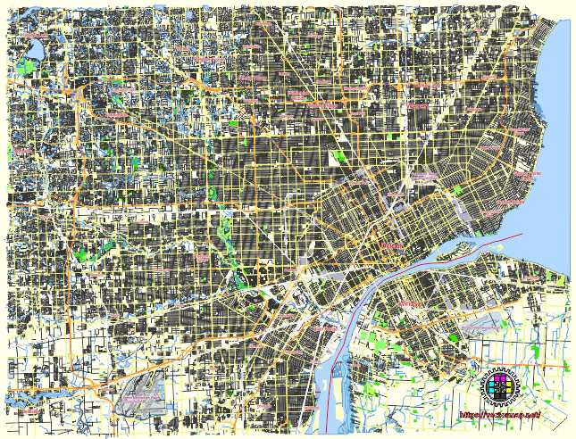
Principal streets and roads, names places, residential streets and roads, road number labels, water objects, land use areas.
Detroit Michigan US editable vector map svg free
DOWNLOAD ARCHIVE FOR FREE >>>
Distributed with Creative Commons Attribution 4.0 International License
SEE ALSO FULL VERSION OF THE Detroit Michigan US vector map (Adobe Illustrator, PDF etc.)
Detroit, Michigan, has a rich and complex urban structure with many notable streets, roads, and districts that play key roles in the city’s layout and identity. Here’s an overview:
Principal Streets and Roads
- Woodward Avenue (M-1)
- Often considered Detroit’s main thoroughfare, running north-south from the Detroit River through downtown and continuing into the suburbs. It is also known as Detroit’s Main Street.
- Jefferson Avenue (M-10)
- Runs parallel to the Detroit River, providing a scenic route through downtown and the east side of the city, continuing into the Grosse Pointes.
- Michigan Avenue (US-12)
- A key east-west route that connects Detroit to Chicago, running through the heart of downtown and westward.
- Grand River Avenue (M-5)
- Another major thoroughfare starting from downtown Detroit and extending northwest through the suburbs.
- Gratiot Avenue (M-3)
- An important northeast-southwest route that starts from downtown Detroit and continues northeast through the suburbs.
- Lafayette Boulevard
- An east-west street that runs through downtown Detroit and is known for its historic architecture.
- 8 Mile Road (M-102)
- Famously known for marking the boundary between Detroit and its northern suburbs, stretching east-west.
- John R Street
- A notable street running through Midtown, known for cultural institutions and historic buildings.
- Cass Avenue
- Runs through Midtown Detroit and is known for its vibrant arts scene and historic significance.
- Van Dyke Avenue (M-53)
- Extends from the east side of Detroit into the northern suburbs, serving as a major north-south route.
Principal City Districts
- Downtown Detroit
- The central business district, home to major corporations, sports arenas, theaters, restaurants, and high-rise buildings. Key landmarks include Campus Martius Park, the Renaissance Center, and the Detroit Riverwalk.
- Midtown Detroit
- Known for cultural institutions like the Detroit Institute of Arts, Wayne State University, and the Detroit Historical Museum. It is a vibrant area with shops, restaurants, and historic neighborhoods.
- Corktown
- One of Detroit’s oldest neighborhoods, known for its Victorian-style homes, Irish heritage, and the popular Michigan Central Station. It is a hub for new businesses and restaurants.
- Eastern Market
- A historic commercial district known for one of the largest public markets in the U.S. It features a variety of fresh produce, meats, spices, and specialty items, attracting large crowds weekly.
- Greektown
- A historic district known for its Greek restaurants, nightlife, and the Greektown Casino.
- New Center
- Located just north of Midtown, this area includes the Fisher Building, Cadillac Place, and Henry Ford Hospital. It is a key commercial and cultural area.
- Indian Village
- A historic residential neighborhood known for its large, ornate homes and well-preserved architecture from the early 20th century.
- Mexicantown
- Located in Southwest Detroit, known for its vibrant Mexican culture, authentic cuisine, and the annual Cinco de Mayo parade.
- Rivertown
- Along the Detroit River, this area includes the Riverwalk, Chene Park, and various parks and recreational spaces.
- Palmer Woods
- A historic, affluent residential neighborhood known for its large, architecturally significant homes and tree-lined streets.
Each of these streets and districts contributes to the unique character and diversity of Detroit, reflecting its rich history and dynamic future.
 Author: Kirill Shrayber, Ph.D. FRGS