Editable Vector Map of the Delray Beach Florida US in SVG format.
Can be edited in the following programs: Adobe Illustrator, CorelDraw, InkScape
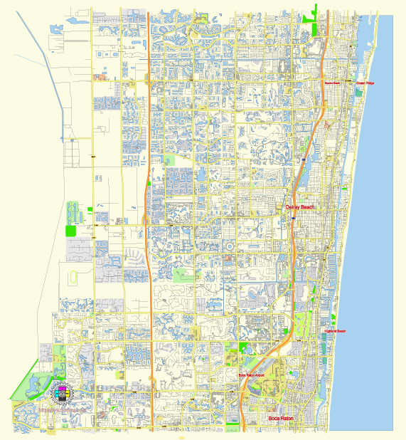
Principal streets and roads, names places, residential streets and roads, road number labels, water objects, land use areas.
Delray Beach Florida US editable vector map svg free
DOWNLOAD ARCHIVE FOR FREE >>>
Distributed with Creative Commons Attribution 4.0 International License
SEE ALSO FULL VERSION OF THE Delray Beach Florida US vector map (Adobe Illustrator, PDF etc.)
Delray Beach, Florida, is a vibrant coastal city known for its charming downtown, beautiful beaches, and diverse neighborhoods. Here are some of the principal streets, roads, and city districts of Delray Beach:
Principal Streets and Roads
- Atlantic Avenue: This is the main street of Delray Beach, stretching from I-95 to the ocean. It’s known for its restaurants, shops, galleries, and nightlife.
- Federal Highway (U.S. 1): A major north-south route that runs parallel to the coastline and provides access to many of Delray Beach’s commercial and residential areas.
- Linton Boulevard: Another key east-west thoroughfare, connecting the western parts of the city to the beach.
- Military Trail: A north-south road located further west, providing access to various residential neighborhoods and commercial areas.
- Congress Avenue: Running parallel to I-95, this road is an important commercial corridor.
- Germantown Road: Known for its residential areas and proximity to local schools and parks.
- Ocean Boulevard (State Road A1A): This scenic coastal road runs along the beach, providing access to beachfront properties and recreational areas.
City Districts
- Downtown Delray Beach: The heart of the city, centered around Atlantic Avenue. It features a mix of dining, shopping, arts, and entertainment options.
- Pineapple Grove Arts District: Located just north of Atlantic Avenue, this district is known for its art galleries, studios, and cultural venues.
- Historic Districts: Delray Beach has several historic districts, including the Marina Historic District and the Old School Square Historic District, featuring preserved historic buildings and homes.
- Osceola Park: A residential neighborhood close to downtown, known for its charming homes and community parks.
- Lake Ida Neighborhood: Located around Lake Ida, this district features single-family homes, parks, and the Delray Beach Playhouse.
- Tropic Isle: A waterfront residential area with canals and luxury homes, located east of Federal Highway.
- The Set (formerly known as West Settlers Historic District): An area west of Swinton Avenue, rich in African American history and culture.
- Palm Trail: A residential neighborhood known for its lush landscaping and proximity to the Intracoastal Waterway.
- Seacrest: A mixed-use neighborhood with both residential and commercial properties, located just north of Atlantic Avenue.
- Delray Shores: A suburban neighborhood with a mix of single-family homes and townhouses, located west of I-95.
These streets and districts define the unique character of Delray Beach, making it a desirable place to live, work, and visit.
 Author: Kirill Shrayber, Ph.D. FRGS