Editable Vector Map of the Dayton and Springfield Ohio US in SVG format.
Can be edited in the following programs: Adobe Illustrator, CorelDraw, InkScape
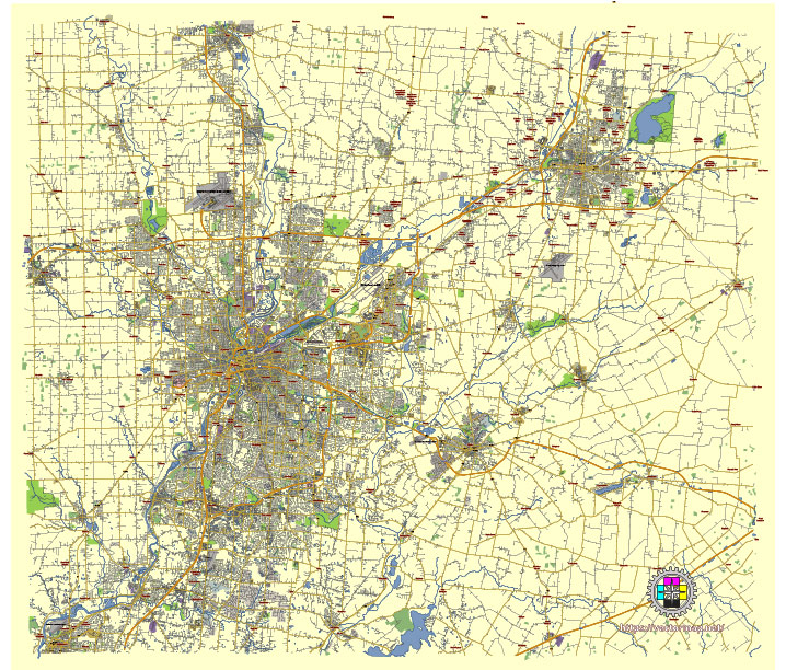
Principal streets and roads, names places, residential streets and roads, road number labels, water objects, land use areas.
Dayton and Springfield Ohio US editable vector map svg free
DOWNLOAD ARCHIVE FOR FREE >>>
Distributed with Creative Commons Attribution 4.0 International License
SEE ALSO FULL VERSION OF THE Dayton and Springfield Ohio US vector map (Adobe Illustrator, PDF etc.)
Dayton and Springfield are two cities in Ohio, each with its unique set of principal streets, roads, and city districts. Here’s an overview of the key areas and thoroughfares in both cities:
Dayton, Ohio
Principal Streets and Roads:
- Main Street – A major north-south street running through downtown Dayton.
- Third Street – A significant east-west thoroughfare.
- Fifth Street – Known for the historic Oregon District.
- Linden Avenue – Runs parallel to US-35.
- Gettysburg Avenue – A north-south arterial road on the west side of Dayton.
- Keowee Street – Connects north Dayton with downtown.
- Patterson Boulevard – Runs along the riverfront and through downtown.
- Brown Street – A hub of activity near the University of Dayton.
- Wayne Avenue – Connects downtown with the Belmont neighborhood.
- North and South Dixie Drive – Major roads in the northern and southern suburbs.
Key Highways:
- Interstate 75 (I-75) – Runs north-south through Dayton.
- Interstate 70 (I-70) – Runs east-west just north of Dayton.
- U.S. Route 35 (US-35) – An east-west route through the city.
- State Route 4 (SR-4) – Connects Dayton to the northern suburbs.
City Districts:
- Downtown Dayton – The central business district.
- Oregon District – Historic area with nightlife, dining, and entertainment.
- Wright-Dunbar – Historical district known for its connection to the Wright brothers.
- University of Dayton – Area surrounding the university campus.
- East Dayton – Residential and industrial area.
- West Dayton – Diverse community with significant historical sites.
- South Park – Residential neighborhood with historic homes.
- Belmont – Residential area in southeast Dayton.
- Riverside – Suburban community to the northeast.
- Kettering – A major suburb south of Dayton.
Springfield, Ohio
Principal Streets and Roads:
- Main Street – The main east-west route through downtown Springfield.
- Limestone Street – A key north-south thoroughfare.
- Fountain Avenue – Runs parallel to Limestone Street.
- High Street – Another significant east-west route.
- Yellow Springs Street – Connects downtown to the southern suburbs.
- Bechtle Avenue – Commercial area with shopping and dining options.
- East Street – Major north-south route on the east side.
- Selma Road – Connects southeastern neighborhoods to downtown.
- Leffel Lane – Connects to Interstate 70 and runs by Clark State Community College.
- Upper Valley Pike – Major commercial corridor in the northwest.
Key Highways:
- Interstate 70 (I-70) – Major east-west highway south of Springfield.
- U.S. Route 68 (US-68) – Runs north-south through the city.
- State Route 4 (SR-4) – Another important north-south route.
City Districts:
- Downtown Springfield – The central business district.
- South Fountain Avenue Historic District – Known for its historic homes.
- East Springfield – Residential area with industrial zones.
- West Springfield – Residential neighborhoods with parks and schools.
- Lagonda – Historic area with industrial roots.
- Northridge – Suburban community to the north.
- Rockway – Residential neighborhood to the west.
- Springfield Township – Surrounds the city and includes various suburban areas.
Both Dayton and Springfield have rich histories and diverse neighborhoods, each contributing to the character and identity of their respective cities.
 Author: Kirill Shrayber, Ph.D. FRGS