Editable Vector Map of the Copenhagen Denmark in SVG format.
Can be edited in the following programs: Adobe Illustrator, CorelDraw, InkScape
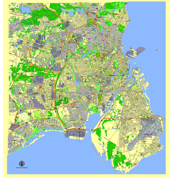
Principal streets and roads, names places, residential streets and roads, road number labels, water objects, land use areas.
Copenhagen Denmark editable vector map svg free
DOWNLOAD ARCHIVE FOR FREE >>>
Distributed with Creative Commons Attribution 4.0 International License
SEE ALSO FULL VERSION OF THE Copenhagen Denmark vector map (Adobe Illustrator, PDF etc.)
Copenhagen, the capital city of Denmark, is known for its rich history, modern architecture, and vibrant culture. Here is an overview of some of the principal streets, roads, and city districts in Copenhagen:
Principal Streets and Roads
- Strøget:
- One of the longest pedestrian streets in Europe.
- Famous for shopping, dining, and entertainment.
- Stretches from City Hall Square (Rådhuspladsen) to Kongens Nytorv.
- Nørrebrogade:
- A major thoroughfare running through the Nørrebro district.
- Known for its multicultural atmosphere, cafes, and independent shops.
- Connects to Queen Louise’s Bridge (Dronning Louises Bro).
- Vesterbrogade:
- Runs through the Vesterbro district.
- Known for its vibrant nightlife, restaurants, and trendy shops.
- Connects to Copenhagen Central Station (Københavns Hovedbanegård).
- Østerbrogade:
- A main street in the Østerbro district.
- Lined with upscale shops, cafes, and parks.
- Leads towards the famous Langelinie promenade and The Little Mermaid statue.
- Gothersgade:
- Located near the city center.
- Runs from Kongens Nytorv to the Østerport area.
- Known for its historical buildings and proximity to Rosenborg Castle and the King’s Garden.
- Amagerbrogade:
- A principal street on the island of Amager.
- Connects the city center to the Amager district.
- Known for a mix of residential areas, shops, and cafes.
City Districts
- Indre By (City Center):
- The historic heart of Copenhagen.
- Home to major attractions like Tivoli Gardens, Christiansborg Palace, and Nyhavn.
- Includes the pedestrian shopping street Strøget.
- Nørrebro:
- Known for its diverse and multicultural vibe.
- Popular for its vibrant nightlife, street art, and eclectic mix of shops and cafes.
- Includes the Assistens Cemetery, where famous Danes like Hans Christian Andersen are buried.
- Vesterbro:
- Once a working-class district, now trendy and popular.
- Famous for its nightlife, dining, and artistic scene.
- Includes the Meatpacking District (Kødbyen), a hub for restaurants and clubs.
- Østerbro:
- An affluent, family-friendly area.
- Known for its green spaces, including Fælledparken and the lakes (Søerne).
- Home to the Little Mermaid statue and the National Stadium, Parken.
- Frederiksberg:
- An independent municipality within Copenhagen.
- Known for its leafy streets, upscale residences, and Frederiksberg Gardens.
- Houses attractions like the Copenhagen Zoo and Frederiksberg Palace.
- Christianshavn:
- A canal district reminiscent of Amsterdam.
- Known for its maritime charm, houseboats, and the Free Town of Christiania.
- Features the Church of Our Saviour with its famous spiral tower.
- Amager:
- Includes a mix of residential, commercial, and recreational areas.
- Home to the University of Copenhagen’s Amager campus and the Amager Strandpark.
- Known for its modern architecture and proximity to Copenhagen Airport.
Additional Notable Streets
- Kongens Nytorv: A central square surrounded by historic buildings and a hub for public transportation.
- Nyhavn: A historic waterfront district with colorful 17th and 18th-century townhouses, bars, cafes, and restaurants.
Copenhagen’s layout blends historic charm with modern development, making it a city that is both rich in culture and innovation.
 Author: Kirill Shrayber, Ph.D. FRGS