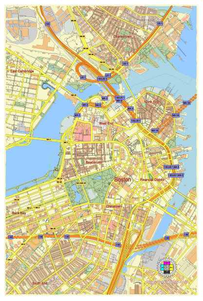
Editable Vector Map of the Boston Central part Massachusetts US in SVG format.
Can be edited in the following programs: Adobe Illustrator, CorelDraw, InkScape
Principal streets and roads, names places, residential streets and roads, road number labels, water objects, land use areas.
Boston Central part Massachusetts US editable vector map svg free
DOWNLOAD ARCHIVE FOR FREE >>>
Distributed with Creative Commons Attribution 4.0 International License
Boston’s central area, often referred to as Downtown Boston, is rich with history and a complex network of streets and districts. Here are some of the principal streets, roads, and districts:
Principal Streets and Roads
- Tremont Street: A major thoroughfare running through the heart of Boston, connecting the Boston Common to the South End.
- Boylston Street: A key commercial street that runs parallel to the Boston Common and extends into the Back Bay area.
- Beacon Street: Known for its historic brownstones, it runs from the Massachusetts State House along the northern edge of the Boston Common and Public Garden.
- Washington Street: A major north-south artery running from Downtown Crossing to the South End.
- Newbury Street: Famous for its shopping and dining, it runs parallel to Boylston Street through the Back Bay.
- Commonwealth Avenue: A grand boulevard with a wide central mall, running from the Public Garden through Back Bay to the Boston University area.
- Atlantic Avenue: Running along the waterfront, it connects the North End to the Seaport District.
- Congress Street: A vital road in the Financial District, extending into the Seaport.
- Cambridge Street: Connecting Government Center to the West End and Beacon Hill.
- Stuart Street: Running through the Theater District and into the Back Bay.
Principal City Districts
- Downtown: The core business district, including Financial District, Government Center, and Downtown Crossing. It features a mix of skyscrapers, historic buildings, and bustling commercial activity.
- Back Bay: Known for its Victorian brownstone homes, upscale shopping along Newbury Street, and the iconic Prudential Center and John Hancock Tower.
- Beacon Hill: Characterized by narrow, gas-lit streets and brick row houses, it’s one of Boston’s oldest and most picturesque neighborhoods.
- North End: Boston’s Little Italy, famous for its Italian restaurants, historic sites like the Paul Revere House, and narrow, winding streets.
- South End: Noted for its Victorian architecture, art galleries, and diverse dining options.
- West End: Home to Massachusetts General Hospital and the TD Garden, it’s a mix of residential, commercial, and institutional buildings.
- Chinatown/Leather District: A vibrant area with a strong Asian community, featuring numerous Asian restaurants and businesses.
- Seaport District: A rapidly developing area with modern buildings, hotels, restaurants, and the Boston Convention and Exhibition Center.
- Theater District: Concentrated around Washington Street and Tremont Street, it’s home to many of Boston’s theaters and performing arts venues.
These streets and districts encapsulate the vibrant and diverse character of central Boston, combining historical significance with modern urban development.
 Author: Kirill Shrayber, Ph.D. FRGS