Editable Vector Map of the Belfast Northern Ireland UK in SVG format.
Can be edited in the following programs: Adobe Illustrator, CorelDraw, InkScape
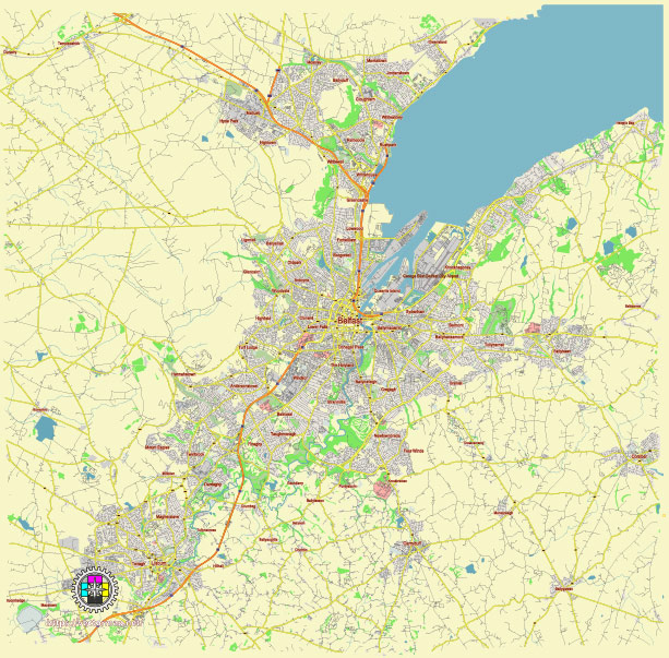
Principal streets and roads, names places, residential streets and roads, road number labels, water objects, land use areas.
Belfast Northern Ireland UK editable vector map svg free
DOWNLOAD ARCHIVE FOR FREE >>>
Distributed with Creative Commons Attribution 4.0 International License
SEE ALSO FULL VERSION OF THE Belfast Northern Ireland UK vector map (Adobe Illustrator, PDF etc.)
Belfast, the capital city of Northern Ireland, has several key streets, roads, and districts that are significant both historically and commercially. Here’s an overview:
Principal Streets and Roads:
- Royal Avenue:
- A major thoroughfare in the city center, known for its shopping and commercial establishments.
- Donegall Place:
- Connects Donegall Square with Royal Avenue, and is a prominent shopping street featuring a variety of high-street stores.
- Lisburn Road:
- Extends from the city center towards the southwest and is known for its boutique shops, cafes, and restaurants.
- Falls Road:
- A road in west Belfast that has historical significance due to its role in the Irish nationalist community.
- Shankill Road:
- Located in west Belfast, it is known for its Unionist heritage and murals.
- Ormeau Road:
- Runs from the city center towards the south and is known for its vibrant nightlife and diverse dining options.
- Antrim Road:
- Heads north out of the city center and passes through areas with scenic views and historical sites.
- Great Victoria Street:
- A major road that houses the Grand Opera House, the Europa Hotel, and the Great Victoria Street railway station.
City Districts:
- City Centre:
- The heart of Belfast, featuring City Hall, major shopping centers like Victoria Square, and numerous restaurants and bars.
- Cathedral Quarter:
- Known for its cultural and artistic vibe, with galleries, studios, and the famous St. Anne’s Cathedral. It also has a lively nightlife scene.
- Titanic Quarter:
- A redeveloped area on the site of the former shipyards, home to the Titanic Belfast museum, offices, and new residential developments.
- Queen’s Quarter:
- Named after Queen’s University Belfast, this district is filled with student housing, pubs, and the Botanic Gardens.
- Gaeltacht Quarter:
- Located around Falls Road, promoting Irish language and culture with various cultural centers and events.
- East Belfast:
- Residential and industrial area, home to the Stormont Estate and C. S. Lewis Square.
- West Belfast:
- Known for its strong Irish nationalist community and cultural heritage, including areas such as the Falls Road and the Gaeltacht Quarter.
- South Belfast:
- A diverse area with affluent residential neighborhoods, shopping streets like Lisburn Road, and green spaces such as Ormeau Park.
- North Belfast:
- A mix of residential and industrial areas, with historical sites and parks, and the bustling Antrim Road.
These streets and districts together form the vibrant and historically rich fabric of Belfast, offering a blend of commercial, cultural, and residential spaces.
 Author: Kirill Shrayber, Ph.D. FRGS