Editable Vector Map of the Beijing China in SVG format.
Can be edited in the following programs: Adobe Illustrator, CorelDraw, InkScape
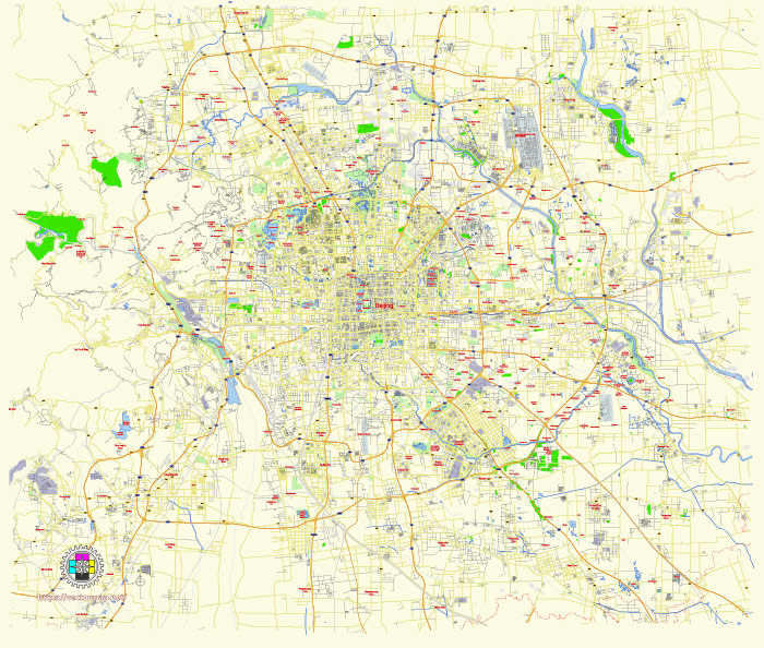
Principal streets and roads, names places, residential streets and roads, road number labels, water objects, land use areas.
Beijing China editable vector map svg free
DOWNLOAD ARCHIVE FOR FREE >>>
Distributed with Creative Commons Attribution 4.0 International License
SEE ALSO FULL VERSION OF THE Beijing China vector map (Adobe Illustrator, PDF etc.)
Beijing, the capital of China, is a vast city with a rich historical and cultural heritage. It is structured with several principal streets, roads, and city districts. Here’s an overview:
Principal Streets and Roads
- Chang’an Avenue (长安街)
- Known as the “First Street in China,” it runs east to west through the city center and passes Tiananmen Square. It is one of the most important and busiest streets in Beijing.
- Wangfujing Street (王府井大街)
- A famous pedestrian street known for its shopping centers, traditional snacks, and cultural significance. It is located in the Dongcheng District.
- Qianmen Street (前门大街)
- A historic commercial street that dates back to the Ming and Qing dynasties. It runs south from Tiananmen Square and is famous for its traditional shops and architecture.
- Financial Street (金融街)
- Located in the Xicheng District, this area is the financial hub of Beijing, housing numerous banks, insurance companies, and financial institutions.
- Third Ring Road (三环路)
- An important ring road that encircles the central part of Beijing. It connects several key districts and provides a major thoroughfare for traffic.
- Fourth Ring Road (四环路)
- Another ring road further out from the city center, it also connects various districts and is crucial for traffic management in Beijing.
Major City Districts
- Dongcheng District (东城区)
- Located in the eastern part of the city center, it is home to many of Beijing’s historical and cultural sites, including the Forbidden City, Tiananmen Square, and Wangfujing Street.
- Xicheng District (西城区)
- Situated in the western part of the city center, it includes important areas such as Financial Street and many government buildings.
- Chaoyang District (朝阳区)
- A large and modern district in the eastern part of Beijing. It is known for its business districts, embassies, and modern developments. Key areas include the Central Business District (CBD) and Sanlitun.
- Haidian District (海淀区)
- Located in the northwest, it is known as the educational and technological hub of Beijing. It houses many universities, including Peking University and Tsinghua University, as well as the Zhongguancun technology area.
- Fengtai District (丰台区)
- Situated in the southern part of Beijing, it is a mix of industrial and residential areas. It is undergoing rapid development with many new infrastructure projects.
- Shijingshan District (石景山区)
- Located in the western part of Beijing, it is known for its scenic spots and historical sites, including the Beijing Shijingshan Amusement Park and the Babaoshan Revolutionary Cemetery.
- Tongzhou District (通州区)
- Positioned in the southeast, it is an emerging sub-center of Beijing with a focus on cultural and administrative development.
- Daxing District (大兴区)
- Found in the southern suburbs, it includes the Beijing Daxing International Airport and is experiencing significant urban expansion.
- Mentougou District (门头沟区)
- Located in the western mountainous area, it is known for its natural beauty and historical sites.
- Shunyi District (顺义区)
- In the northeast, it is known for the Beijing Capital International Airport and its rapidly growing residential areas.
These principal streets, roads, and districts form the core framework of Beijing, contributing to its dynamic urban landscape and cultural richness.
 Author: Kirill Shrayber, Ph.D. FRGS