Editable Vector Map of the Baton Rouge Louisiana US in SVG format.
Can be edited in the following programs: Adobe Illustrator, CorelDraw, InkScape
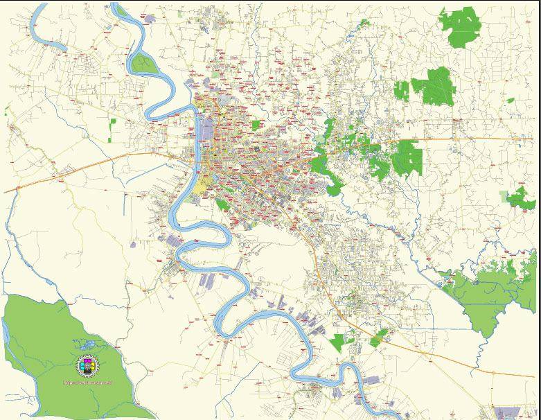
Principal streets and roads, names places, residential streets and roads, road number labels, water objects, land use areas.
Baton Rouge Louisiana US editable vector map svg free
DOWNLOAD ARCHIVE FOR FREE >>>
Distributed with Creative Commons Attribution 4.0 International License
SEE ALSO FULL VERSION OF THE Baton Rouge Louisiana US vector map (Adobe Illustrator, PDF etc.)
Baton Rouge, Louisiana, the capital city of the state, is organized into various districts and is traversed by several major streets and roads. Here are some of the principal streets, roads, and districts in Baton Rouge:
Principal Streets and Roads
- Interstate 10 (I-10)
- Runs east-west through the southern part of Baton Rouge, connecting it to New Orleans to the east and Lafayette to the west.
- Interstate 12 (I-12)
- Splits from I-10 in Baton Rouge and runs east towards Hammond, bypassing New Orleans.
- Interstate 110 (I-110)
- A north-south spur of I-10, running from downtown Baton Rouge to the northern suburbs and the Baton Rouge Metropolitan Airport.
- U.S. Highway 61 (Airline Highway)
- A major north-south route that runs parallel to I-110, connecting Baton Rouge with the northern and southern parts of the state.
- U.S. Highway 190 (Florida Boulevard)
- An east-west route that runs through the northern part of the city, providing access to the Mississippi River Bridge and other parts of East Baton Rouge Parish.
- Louisiana Highway 30 (Nicholson Drive)
- Runs from downtown Baton Rouge to the southern suburbs, passing by Louisiana State University (LSU).
- Perkins Road
- A major thoroughfare that runs parallel to I-10, serving the southeastern part of the city.
- Highland Road
- A scenic route that starts near downtown and winds through the southern part of the city, passing by LSU.
- Government Street
- Runs east-west through the mid-city area, known for its historic homes, local businesses, and cultural attractions.
City Districts
- Downtown Baton Rouge
- The central business district of the city, featuring government buildings, cultural attractions, and a growing number of residential and commercial developments.
- Mid City
- An eclectic and historic area known for its vibrant arts scene, local businesses, and the annual Mid City Merchants’ events.
- Garden District
- A residential neighborhood with beautiful historic homes, tree-lined streets, and close proximity to downtown.
- Spanish Town
- The oldest neighborhood in Baton Rouge, famous for its colorful homes and the annual Spanish Town Mardi Gras Parade.
- LSU and South Baton Rouge
- Encompassing Louisiana State University and the surrounding areas, this district is known for its college-town atmosphere, sports venues, and student housing.
- Highland-Perkins
- A residential and commercial area known for its mix of upscale homes, shopping centers, and restaurants.
- Bocage-Citi Place
- A commercial and residential district featuring high-end shopping, dining, and business offices.
- Sherwood Forest
- A large residential neighborhood in the eastern part of the city, known for its suburban feel and family-friendly environment.
- Scotlandville
- Located in the northern part of the city, this district includes Southern University and A&M College, a historically black university.
- Southdowns
- A residential area with mid-century homes, known for the annual Southdowns Mardi Gras Parade and its close-knit community feel.
These streets and districts represent the diverse and dynamic nature of Baton Rouge, offering a mix of historical charm, academic influence, commercial development, and suburban living.
 Author: Kirill Shrayber, Ph.D. FRGS