Editable Vector Map of the Baltimore Maryland US in SVG format.
Can be edited in the following programs: Adobe Illustrator, CorelDraw, InkScape
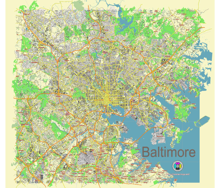
Principal streets and roads, names places, residential streets and roads, road number labels, water objects, land use areas.
Baltimore Maryland US editable vector map svg free
DOWNLOAD ARCHIVE FOR FREE >>>
Distributed with Creative Commons Attribution 4.0 International License
SEE ALSO FULL VERSION OF THE Baltimore Maryland US vector map (Adobe Illustrator, PDF etc.)
Baltimore, Maryland, is a city rich in history and culture, with numerous principal streets, roads, and distinct city districts. Here are some of the key streets and districts in Baltimore:
Principal Streets and Roads
- Charles Street: One of the main north-south streets, running through the heart of Baltimore. It passes through significant areas including downtown, Mount Vernon, and the Charles Village neighborhood.
- Pratt Street: A major east-west street that runs through the Inner Harbor area, an important commercial and tourist center.
- Baltimore Street: Another significant east-west street, particularly known for traversing downtown Baltimore.
- York Road: Extends north from the city and serves as a major thoroughfare connecting Baltimore to its northern suburbs.
- Martin Luther King Jr. Boulevard: Encircles downtown Baltimore on the western side and connects several key neighborhoods and institutions.
- Eastern Avenue: Runs east-west and is notable for passing through the Fells Point and Highlandtown neighborhoods.
- North Avenue: A major east-west street that runs across the northern part of the city, connecting several neighborhoods.
- Harford Road: Another significant north-south route that extends from the city into the northeastern suburbs.
- Falls Road: Known for running parallel to the Jones Falls River, it provides a scenic route through parts of the city.
- Key Highway: Runs along the southern edge of the Inner Harbor and provides access to Federal Hill and Locust Point.
Key City Districts
- Inner Harbor: The central waterfront area, known for attractions like the National Aquarium, Maryland Science Center, and numerous shops and restaurants.
- Downtown: The central business district of Baltimore, encompassing office buildings, government institutions, and cultural venues.
- Fells Point: A historic waterfront neighborhood known for its cobblestone streets, bars, and restaurants.
- Canton: A vibrant waterfront neighborhood known for its nightlife, Canton Square, and the Canton Waterfront Park.
- Mount Vernon: Known for its cultural institutions, including the Walters Art Museum and the Peabody Institute, as well as the Washington Monument.
- Federal Hill: A historic neighborhood offering panoramic views of the Inner Harbor and known for its nightlife and Federal Hill Park.
- Hampden: Known for its quirky shops, restaurants, and the annual “HonFest” celebrating Baltimore’s working-class culture.
- Little Italy: Renowned for its Italian restaurants, cultural events, and proximity to the Inner Harbor.
- Charles Village: A residential neighborhood known for its colorful “painted ladies” row houses and Johns Hopkins University.
- Harbor East: A newer, upscale neighborhood with high-end shopping, dining, and residential spaces, adjacent to the Inner Harbor.
- Highlandtown: Known for its diverse population and vibrant arts scene, particularly around the Highlandtown Arts District (Ha!).
- Pigtown: A historic neighborhood known for its annual “Pigtown Festival” and proximity to Camden Yards, home of the Baltimore Orioles.
- Roland Park: One of the first planned suburban communities in the U.S., known for its beautiful homes and lush landscapes.
Each of these streets and districts contributes to the unique character and charm of Baltimore, making it a diverse and vibrant city.
 Author: Kirill Shrayber, Ph.D. FRGS