Editable Vector Map of the Antwerpen Belgium in SVG format.
Can be edited in the following programs: Adobe Illustrator, CorelDraw, Inkscape
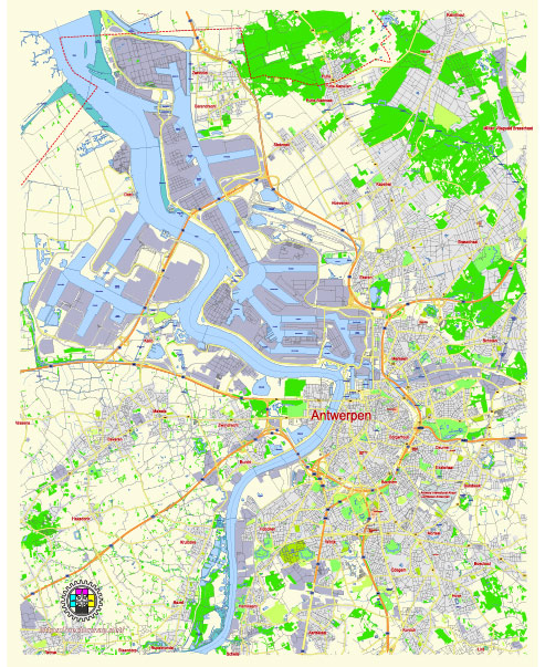
Principal streets and roads, names places, residential streets and roads, road number labels, water objects, landuse areas.
Antwerpen Belgium editable vector map svg free
DOWNLOAD ARCHIVE FOR FREE >>>
Distributed with Creative Commons Attribution 4.0 International License
SEE ALSO FULL VERSION OF THE Antwerpen Belgium vector map (Adobe Illustrator, PDF etc.)
Antwerpen (Antwerp) is a major city in Belgium known for its rich history, culture, and economic significance, especially in the diamond trade and port activities. Here’s an overview of some of the principal streets, roads, and city districts in Antwerp:
Principal Streets and Roads
- Meir:
- One of the most famous shopping streets in Antwerp, known for its high-end stores, historical buildings, and vibrant atmosphere.
- De Keyserlei:
- A bustling street leading from Antwerp Central Station to the city center, lined with shops, cafes, and restaurants.
- Kipdorpbrug:
- A key road that provides access to the inner city and connects various districts.
- Italielei:
- Part of the major ring road system, providing important north-south connectivity.
- Leien (Frankrijklei, Italiëlei, Belgiëlei, Amerikalei):
- A series of wide boulevards that form a semi-circle around the city center, critical for traffic flow and public transport routes.
- Carnotstraat:
- Connects the Central Station area to the neighborhoods to the east, with a mix of residential and commercial establishments.
- Sint-Katelijnevest:
- Close to the Cathedral of Our Lady, this street features a mix of shops, restaurants, and historical sites.
Principal City Districts
- Antwerp City Center (Binnenstad):
- Includes key landmarks like the Cathedral of Our Lady, the Grote Markt, and the City Hall. Known for its historical buildings, vibrant nightlife, and cultural attractions.
- Het Zuid:
- A trendy district known for its art galleries, museums (like the Museum of Contemporary Art), and lively cafes and restaurants.
- Zurenborg:
- Renowned for its Belle Époque architecture and vibrant street life, especially around Dageraadplaats and Cogels-Osylei.
- Eilandje:
- The docklands area, now revitalized with modern architecture, museums like MAS (Museum aan de Stroom), and a bustling waterfront.
- Borgerhout:
- A multicultural neighborhood east of the city center, known for its diverse community and vibrant street markets.
- Berchem:
- A residential and commercial area with beautiful parks and a mix of modern and historical buildings.
- Linkeroever:
- Located on the left bank of the Scheldt River, offering stunning views of the Antwerp skyline, residential neighborhoods, and recreational areas.
- Deurne:
- Known for its green spaces, including the Rivierenhof park, and a mix of residential and commercial zones.
- Hoboken:
- A suburban district with a mix of residential areas and industrial zones.
- Merksem:
- Primarily residential with a variety of shops and local businesses.
These streets and districts reflect Antwerp’s diversity, from historic centers and bustling shopping streets to trendy neighborhoods and suburban areas, contributing to the city’s dynamic and multifaceted character.
 Author: Kirill Shrayber, Ph.D. FRGS