Editable Vector Map of the Amsterdam Netherlands in SVG format.
Can be edited in the following programs: Adobe Illustrator, CorelDraw, Inkscape
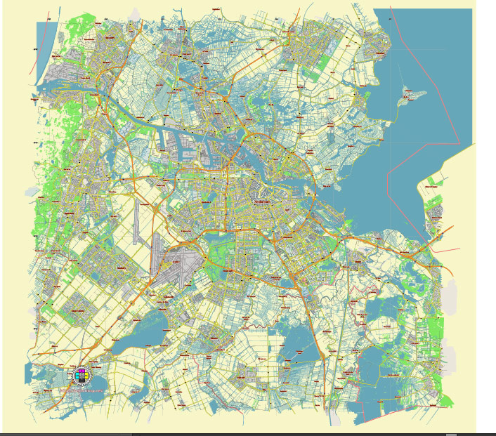
Principal streets and roads, names places, residential streets and roads, road number labels, water objects, landuse areas.
DOWNLOAD ARCHIVE FOR FREE >>>
Distributed with Creative Commons Attribution 4.0 International License
SEE ALSO FULL VERSION OF THE Amsterdam Netherlands vector map (Adobe Illustrator, PDF etc.)
Amsterdam, the capital city of the Netherlands, is known for its historic canals, museums, and vibrant cultural scene. The city is divided into several districts, each with its own unique character and attractions. Here are some of the principal streets, roads, and districts in Amsterdam:
Principal Streets and Roads
- Damrak: This is one of the main streets in central Amsterdam, running from Amsterdam Centraal Station to Dam Square. It’s a busy commercial area with many shops, restaurants, and tourist attractions.
- Rokin: Another major street that runs from Dam Square to Muntplein. It is lined with shops, cafes, and historical buildings.
- Leidsestraat: A key shopping street that runs from Koningsplein to Leidseplein, known for its high-end shops and vibrant atmosphere.
- Kalverstraat: One of the busiest shopping streets in Amsterdam, running from Dam Square to Muntplein. It is lined with a variety of shops and boutiques.
- Nieuwendijk: Another popular shopping street that starts from Amsterdam Centraal Station and runs parallel to Damrak.
- Prinsengracht, Keizersgracht, and Herengracht: These are three of the main canals in Amsterdam, surrounded by some of the city’s most beautiful and historic streets. They form part of the famous Canal Belt.
- Van Baerlestraat: This street runs through the Museum Quarter and is known for its proximity to the Rijksmuseum, Van Gogh Museum, and Concertgebouw.
- P.C. Hooftstraat: Known for its luxury shopping, this street is home to high-end fashion boutiques and designer stores.
- Ferdinand Bolstraat: A vibrant street in the De Pijp district, known for its shops, cafes, and the famous Albert Cuyp Market.
- Amstelveenseweg: A major road running from the city center towards the southern suburbs and Amsterdamse Bos, a large urban park.
City Districts
- Centrum: The historical heart of Amsterdam, including the Canal Belt, the Red Light District, Dam Square, and many of the city’s main attractions.
- Jordaan: A picturesque neighborhood known for its narrow streets, art galleries, independent shops, and traditional Dutch pubs.
- De Pijp: A lively, multicultural district famous for its markets (including the Albert Cuyp Market), cafes, and nightlife.
- Museumkwartier (Museum Quarter): Home to several of Amsterdam’s most famous museums, including the Rijksmuseum, Van Gogh Museum, and Stedelijk Museum.
- Oud-Zuid (Old South): A prestigious residential area with beautiful architecture, high-end shopping on P.C. Hooftstraat, and the expansive Vondelpark.
- De Wallen (Red Light District): Known for its legal prostitution and coffee shops, this area also contains some of Amsterdam’s oldest buildings and picturesque canals.
- Oost (East): A diverse district with a mix of residential areas, parks like Oosterpark, and cultural attractions such as the Tropenmuseum.
- West: Includes neighborhoods like Oud-West and Westerpark, known for their vibrant communities, parks, and cultural venues.
- Noord (North): Accessible by a short ferry ride from Centraal Station, this rapidly developing area features creative hubs, green spaces, and the iconic A’DAM Tower.
- Zuidoost (Southeast): A multicultural district known for its modern architecture, the Amsterdam Arena, and the Bijlmermeer residential area.
These streets and districts reflect the diverse and dynamic character of Amsterdam, making it a fascinating city to explore.
 Author: Kirill Shrayber, Ph.D. FRGS