Urban plan Geelong Australia PDF: Editable Vector Maps
Gallery of Images "Urban plan Geelong Australia PDF":
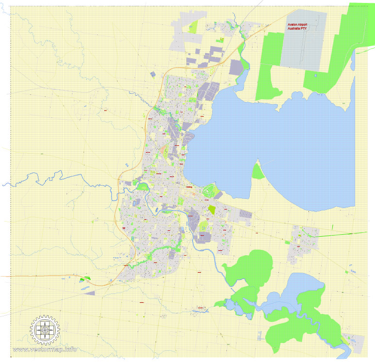
Geelong Victoria Australia: Digital Vector Maps


City of Greater Geelong: Editable Vector Cartography for Business, Education


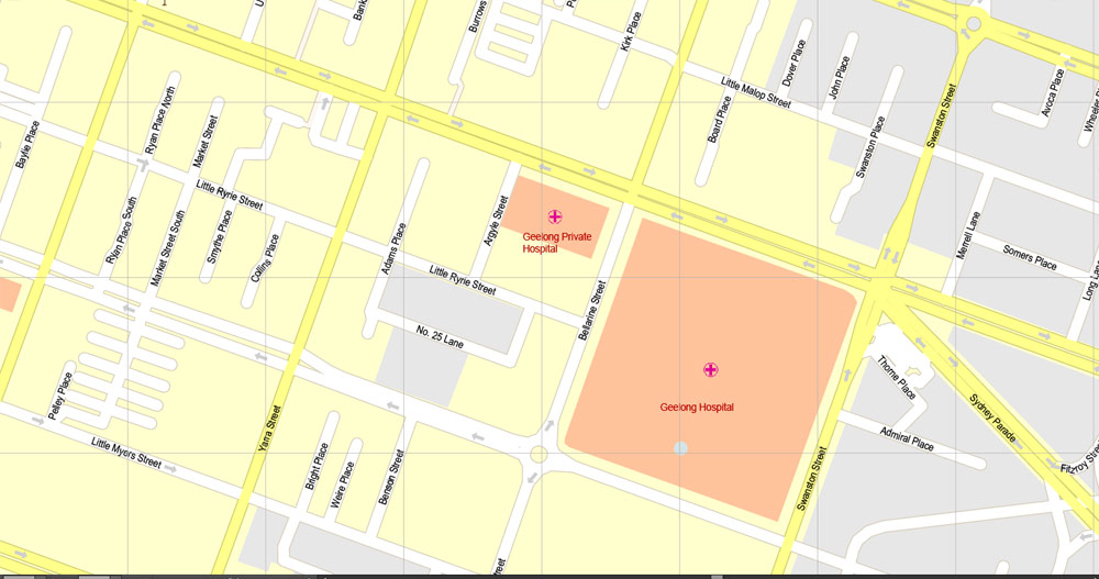
Urban plan Geelong Australia PDF: fully editable city maps in Vector Formats: AutoCAD DWG DXF, Adobe Illustrator, PDF
Geelong, Victoria, Australia
Geelong is a port city located in Corio Bay and the Barwon River, in Victoria, Australia. It is located 75 kilometers (47 miles) southwest of the state capital, Melbourne. It is the second-largest city in Victoria, with an estimated urban population of 184,182.
Geelong runs from the Lara Plains in the north to the hilly terrain of the Warne Reservoirs in the south to Corio Bay. Geelong is the administrative center of the Municipality of Geelong, which covers the urban, rural, and coastal areas surrounding the city, including the Bellarine Peninsula.
Geelong got its name in 1827, which most likely means "Land" or "cliffs". The area began to be built up in 1838, three weeks after Melbourne. A post office was opened by June 1840 (the second one opened in Port Philip). During the gold rush, Geelong experienced a boom as the main port that allowed access to the rich gold mines of the Ballarat area. The city then diversified in industry, and during the 1860s it became one of the largest manufacturing centers in Australia with its woolen mills and paper mills.
Erskine Waterfall is not very big, but it is extremely picturesque. The height of the waterfall is thirty meters, it is surrounded by eucalyptus trees and many ferns. It is not so difficult to find the Erskine Waterfall – it is located a five-minute drive from the city of Lorne in Victoria. The path from the parking lot is no more than a hundred meters. To get down to Erskine, you will have to overcome a small staircase. You can approach the waterfall itself and even swim.
Geelong has stable weather, and yet four seasons are expected here. It has a temperate oceanic climate with prevailing westerly winds, variable clouds, moderate precipitation, warm summers, and moderately cool winters. February is the hottest month and July is the coldest. The highest recorded temperature was 47.4 °C (117.3 °F) on February 7, 2009, the lowest was −4.4 °C (24.1 °F) registered on August 5, 1997. The average annual precipitation is 520 mm (20.5 in), which makes Geelong the driest major city in Australia.
There are several nature reserves and national parks around the city, where you can get acquainted with the amazing nature of South Australia.
The favorite vacation spot of Geelong residents is the East Beach
Summer in Geelong is warm and sunny, which creates excellent opportunities for various water sports, primarily sailing.
Victoria is the smallest state on the Australian mainland. Its area is 237.6 thousand km2 and occupies only 3% of the Australian continent, about a quarter of all residents of the country live here — 5,496 million people (according to 2021). It is worth noting that the ethnic composition of the population of Victoria is very diverse, which is due to the two waves of immigration that the state experienced at one time. The first of them was caused by the "gold rush" that broke out in 1851, which was provoked by the discovery of rich gold deposits, the second happened after the end of the Second World War. The state owes its name to the English Queen Victoria. It was she who, in the middle of the 19th century, listened to the request of enterprising residents of Melbourne, which was part of New South Wales at that time and allowed to establish a new independent state with its capital in the city.
Agriculture in Victoria is well developed, first of all, it is an industrial and agricultural region since its economy is based on industry. Yes, almost 60% of the state's land is occupied by farms where grain, fodder, fruit (pears and apples) and vegetable crops, Australian tobacco, as well as grapes are grown. The region is the center of Australian dairy and beef cattle breeding, producing 2/3 of milk in the country. Victorians specialize in the cultivation of fine-fleeced breeds of sheep, the shearing of wool from which accounts for 20% of all Australian production.
The largest contribution to the economic development of the region is made by industry: food, mining, chemical, military, oil refining, as well as mechanical engineering. The largest enterprises in Victoria are the assembly plants of the automobile corporations General Motors, Ford, and Toyota, which produce 50% of the cars manufactured in Australia from their conveyors. Metallurgical plants, the largest of which are Alcoa in Portland and Point Henry, produce 40% of the national aluminum. The main minerals that are extracted from the subsoil are energy carriers (oil, gas, and brown coal), they account for 90% of all production.
The climate of the state
The small territory of Victoria is distinguished by a unique variety of natural and climatic zones. The hot semi-desert climate reigns in the northwest with temperature fluctuations throughout the year from +15 to +30 °It changes unrecognizably, approaching the coast - it turns into a mild, temperate continental. The coldest part of the state is the Victorian Alps, belonging to the Great Dividing Range. Here the climate is wetter and cooler, and winter temperatures in the highest places reach zero.
Related Images "Urban plan Geelong Australia PDF":
Geelong Victoria Australia: Digital Vector Maps

Digital Maps of Australia: for Business and Logistics


Development Planning of Geelong Victoria Australia: Digital Cartography


- Urban plan Portland Oregon 25
- Urban plan San Francisco Oakland
- Urban plan Richmond Virginia PDF
- Urban plan Delray
- Urban plan Bohol Panglao Philippines
- Urban plan Miami Florida 4
- Urban plan Izhevsk PDF Russia
- Urban plan Helena Montana
- Urban plan Juneau Alaska PDF
- Urban plan Pforzheim Germany pdf
- Urban plan Columbus Ohio
- Urban plan Raleigh North Carolina PDF
- Urban plan Perth Australia AI v309
- Urban plan Vasteras Sweden ai
- Urban plan Tel Aviv Yafo Israel hebrew 17 PDF
- Urban plan Relief US flat
- Urban plan Pacific Coast US Canada PDF
- Urban plan Chicago
- Urban plan Seattle Washington
- Urban plan Europe Full Extra Detailed PDF
- Urban plan Albury Wodonga Australia 17
- Urban plan Syktyvkar
- Urban plan Pyrenees Relief Roads PDF
- Urban plan Madrid Spain AI
- Urban plan Ghent Belgium PDF
- Urban plan Charleston South Carolina 3 10 AI
- Urban plan Albuquerque ai
- Urban plan Jerusalem Israel 17 PDF
- Urban plan Odessa Ukraine PDF
- Urban plan Texas Counties
- Urban plan Tokyo Japan
- Urban plan Tel Aviv Yafo Israel ENG 132
- Urban plan Bordeaux France
- Urban plan Los Angeles California
- Urban plan Toronto Canada PDF
- Urban plan Albuquerque NM
- Urban plan Dublin Ireland ai
- Urban plan Austria Admin
- Urban plan Lille France pdf
- Urban plan Barnstable Massachusetts
- Urban plan Cairns Australia 17
- Urban plan La Porte Baytown Texas pdf
- Urban plan Dresden Germany
- Urban plan Cleveland Ohio CDR
- Urban plan Corrientes Resistencia PDF
- Urban plan Moscow low detailed pdf
- Urban plan Calgary City SVG
- Urban plan Europe Full Extra Detailed AI
- Urban plan Rochester New York PDF
- Urban plan Bruxelles Brussels Belgium CDR
- Urban plan Wollongong Australia PDF
- Urban plan Ireland Island
- Urban plan Tel Aviv Yafo Israel 17 PDF
- Urban plan Finland Admin
- Urban plan Victoria Canada pdf
- Urban plan Yale University New Haven Connecticut SVG
- Urban plan San Jose California ai
- Urban plan Leipzig Germany
- Urban plan Bremen Germany
- Urban plan Manila Grande Philippines 16 AI
- Urban plan Charlotte North Carolina PDF
- Urban plan Salt Lake City Metro PDF
- Urban plan Cape Canaveral Florida PDF
- Urban plan Jakarta Indonesia 16 ai
- Urban plan La Porte Baytown Texas pdf 15
- Urban plan Bristol Cardiff Newport UK
- Urban plan Walt Disney World Florida
- Urban plan Karlsruhe Germany PDF
- Urban plan Penza Russia
- Urban plan Spokane Washington AI
- Urban plan Massachusetts State CDR
- Urban plan Istanbul Turkey CDR
- Urban plan Quebec City Canada 13 PDF
- Urban plan Samara pdf
- Urban plan Calgary Canada PDF
- Urban plan Duesseldorf Germany ai
- Urban plan Frankfurt am Main
- Urban plan Tomsk pdf
- Urban plan Springfield Missouri
- Urban plan Alphen Aan Den Rijn Netherlands
- Urban plan Allentown Easton Pennsylvania PDF
- Urban plan full Italy adm phys
- Urban plan Milwaukee Wisconsin
- Urban plan Montreal and surroundings Canada
- Urban plan Austin Texas PDF
- Urban plan Adelaide Australia 3 11
- Urban plan Spokane PDF
- Urban plan Haifa Israel pdf
- Urban plan Wisconsin State
- Urban plan Brooklyn New York PDF
- Urban plan Massachusetts State PDF
- Urban plan La Porte Baytown Texas ai 17
- Urban plan Birmingham Alabama pdf
- Urban plan Sioux City Iova pdf
- Urban plan Birmingham Alabama ai
- Urban plan Jakarta Indonesia autocad dwg
- Urban plan Utrecht Netherlands pdf
- Urban plan Izhevsk PDF Russia
- Urban plan Yaroslavl
- Urban plan Berlin Germany
- Urban plan Aarhus Denmark pdf