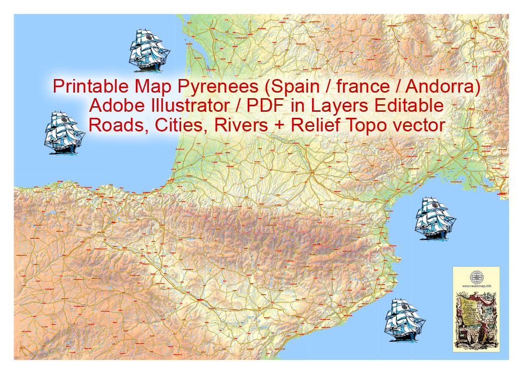
Urban plan Pyrenees Relief Roads PDF
Related Images "Urban plan Pyrenees Relief Roads PDF":
Pyrenees Maps Vector: Cartography for travel and education


Pyrenees Digital Cartography for business, logistics, education


Tourist plan Pyrenees Relief Roads PDF High Detailed Maps
Pyrenees: Short Description
Location of the Pyrenees: located in southwestern Europe on the territory of Spain, France, and Andorra.
Length of the Pyrenees: 450 km
The structure of the Pyrenees: Central (from Somport Pass to Carlit Peak), Western (from the Atlantic Ocean to Somport Pass), and Eastern Pyrenees (from Carlit Peak to the Mediterranean Sea).
The highest peaks of the Pyrenees: Aneto Peak (3404 m).
Minerals of the Pyrenees: bauxite, iron ore, marble, granite.
The climate of the Pyrenees: temperate, humid in most of the territory, subtropical in the south-eastern part. The average temperature in January at an altitude of up to 500-600 m is 4-8 degrees Celsius, in July in the foothills it is 20-24 degrees. Precipitation: from 1500-2400 mm per year on the northern slopes, up to 500-750 mm on the southern slopes.
Flora and fauna of the Pyrenees: up to a height of 1800-2100 m, deciduous and coniferous forests (oak, chestnut, maple, beech, spruce, fir, birch) prevail. Shrubs are common here on the southern and eastern slopes of the height of 500-700 m. Mammals include chamois, wild boar, badger, Pyrenean ibex, Genetta and others.
Relief: Details about the Pyrenees
PYRENEES, ort the Pyrenees Mountains (Spanish Pirinéos, French. Pyrénées), a mountain system in southwestern Europe, in Spain, France, and Andorra. In latitude, they stretch from the Bay of Biscay to the Mediterranean Sea for a distance of over 450 km, delimiting the Iberian Peninsula from the continental part of Europe; a width up to 110 km.
In terms of height, the Pyrenees occupy the 2nd place in Western Europe after the Alps and are characterized by relatively small fragmentation and inaccessibility (the height of the passes is 1500-2000 m). The northern microcline (steeper and shorter) descends to the Garonne lowland, the southern one is divided by longitudinal valleys into low- and medium-altitude ridges, the heights of which gradually decrease to the Aragon Plain. In general, the relief is characterized by a complex combination of folded rectilinear limestone and flysch ridges and medium-high flat-topped crystals. arrays. There are medium-altitude (up to 2504 m, Ani peak), which means. Erosive dismemberment of the Pyrenees (from the Biscay Hall. to Somport Pass), the highest center. Pyrenees (up to 3404 m high, Aneto peak in the Maladeta massif is the highest point of the Pyrenees) - from Somport Pass to Karlit Peak and the Eastern Pyrenees (up to 2910 m high, Puchmal Mountain), strongly fragmented into separate ridges and massifs, with an abundance of intercountry basins. The Central Pyrenees, which were subjected to Pleistocene glaciation, are characterized by Alpine relief forms: karst ridges, circuses, trogon valleys; on the north. small hanging and karst glaciers have been preserved on the slopes (there are 41 of them in total; 1993). Many areas of the Pyrenees are karst: deep karst cavities (Pierre-Saint-Martin, up to 1350 m, is one of the deepest in the world), underground rivers, carsts, etc.

Geological structure and minerals
In tectonic terms, the Pyrenees are a fold-cover system, which is a link of the Alpine-Himalayan mobile belt and arose on the border of the Eurasian and Iberian lithospheric plates in the late Eocene. The Pyrenees are bordered by advanced bends – the Adur in the north and the Ebro in the south. In the structure of the Pyrenees, there are Axial, North-Pyrenean, and South-Pyrenean zones. Numerous are marked in the Axial Zone. protrusions of the Hercynian base (metamorphosed clay-shale strata of the Cambrian - Silurian, terrigenous-carbonate deposits of the Devonian - Middle Carboniferous, overlain by molasses of the Upper Carboniferous - Permian and broken by granitoids). Presumably, Precambrian gneisses and granulites lie under the Paleozoic complexes; the sediments overlying the Paleozoic are represented by salt-bearing strata and volcanoes of the Triassic and platform accumulations of the Jurassic - Lower Cretaceous. The axial zone is pushed over the narrow North-Pyrenean zone of the folded-thrust structure, composed of projections of the Hercynian base, deep-water clay shales of the upper part of the Lower Cretaceous, into which mantle peridotites are embedded, as well as carbonate flysch of the Upper Cretaceous. The wider South Pyrenean zone has a typical cover structure: upper tectonic. The covers are composed of Mesocainozoic platform deposits, the lower covers are composed of the Hercynian complex. The advanced deflections are filled with Oligocene-Miocene molasses (Oligocene evaporites are enclosed in the Ebro molasses deflection; South. the wing of the Adura deflection is deformed). The Pyrenean mobile system was laid at the end of the Early Cretaceous, when, simultaneously with the opening of the Bay of Biscay, a deep rift trough appeared on the Hercynian base. At the beginning of the Late Cretaceous, the deflection experienced the first compression pulse; at the turn of the Cretaceous and Paleogene, the second phase of deformations appeared; the main phase of folding and covering - the Pyrenean - occurred in the late Eocene (on the southern slope, deformations continued in the Oligocene). The general uplift of the Pyrenees began with the Miocene.
Deposits of iron ores are known (in the west, near Renteria, in the east of Bath), brown coal (Figols, on the southern slope), bauxite (near Tarascon-sur-Ariege, on the northern slope), manganese ores (in the Nest River valley), fluorite (Escaro, in the east), talc (Luzenak, in the northeast), granites, marbles. There are numerous thermal springs.
Climate
In the western part of the Pyrenees, the climate is transitional from subtropical to temperate, humid, in the southeast - subtropical, Mediterranean. The average temperatures in January at an altitude of 500-600 m are 4-8 °C, in July from 18 °C in the west to 23 °C in the east; in the highlands, the average temperatures in January are from -8 to -10 °C, in July from 5 to 10 °C. The most humidified are the northern slopes of the Pyrenees, on which 1500-2400 mm of precipitation falls per year, on the southern slopes of the slopes 500-750 mm. In most of the territory, the intra-annual precipitation distribution is uniform, in the southeast, the summer minimum is pronounced. The height of the snow line is 2400-2800 m on the northern slopes and up to 3000 m on the southern slopes. The total area of modern glaciation is 8.1 km2.
Rivers and lakes
The Pyrenees rivers flow in narrow, deep, often canyon-like valleys, often form waterfalls (for example, Gavarni), and have significant hydropower potential. The rivers of the northern macroscline belonging to the Garonne and Adour basins are full-flowing, the rivers of the southern slope (mainly tributaries of the Ebro – Aragon, Gallego, Cinca) are characterized by a decrease in summer runoff. There are numerous karst lakes, mostly small in area. Underground rivers and waterfalls are found in the limestone distribution areas. For the needs of hydropower and irrigation, the Cap-de-Lon (France), Esa (Spain), and other reservoirs have been created.
Soils, flora, and fauna
In a significant part of the Pyrenees up to an altitude of 1800-2100 m, mountain and forest landscapes predominate. Oak forests grow on the northern macroscline and on the western well-moistened slopes in the low mountains (in the west – from oak with an admixture of chestnut and maple; in the east - from fluffy oak). Brown mountain-forest soils predominate in the soil cover, sod-carbonate soils have formed on limestone. Beech forests are typical for the middle categories; in the lower part – with the participation of subtropical species in the undergrowth and ground cover (boxwood, holly), in the upper part - with Atlantic and Central European elements in the ground cover (sour, blueberry). Above 1800 m beech forests are replaced by coniferous – mainly fir, on dry slopes – pine forests. On the southern and eastern slopes, low-mountain landscapes are characterized by an alternation of rare-coniferous forests from subtropics. oak species with shrubby and low-wood-shrub formations of maquis and gariga (shrubby vegetation prevails in the southeastern part of the Pyrenees) on mountain brown and sod-carbonate soils. Forests of subtropical pine species are developed in the midlands, beech is rare. Above the upper border of the forest, subalpine landscapes are widespread, represented by crooked forests of mountain pine with rhododendron or dwarf juniper and tall grass meadows. In the highlands, low-grass alpine meadows on sod mountain meadow soils alternate with swamps, rocky scree, and subnival groupings.
The floristic diversity of the Pyrenees is great: over 3,500 plant species, of which 200 are endemic to the region. There are over 75 species of mammals and about 200 species of birds in the Pyrenees. There are chamois, wild boar, Alpine marmot, of the species endemic to the Pyrenees – Pyrenean muskrat, Pyrenean mountain newt. Populations of brown bears and wolves are being restored within the protected areas.
The anthropogenic transformation of the Pyrenees landscapes is moderate. The most developed are the foothills and inland basins, where cultivated vegetation prevails (fields, vineyards, orchards, olive plantations, and forest plantations). Subalpine and alpine meadows are traditionally used for pastures. Numerous protected natural areas have been created in the Pyrenees, most of which are included in the pan-European ecological network "Natura 2000": Ordesa y Monte Perdido National Park, the Visites Maladeta Natural Parks, Valles Occidentales, the High Pyrenees (Spain), the Pyrenees National Park (France). The alpine landscapes of the Pyrenees as part of the natural and cultural object Monte Perdido Mountain (France, Spain) and the cultural object Madriu Perafita Claror Valley (Andorra) are included in the World Heritage List (classical glacial landforms, high biodiversity, traditional nature management in the highlands).
On the basis of thermal mineral springs, the resorts of Aks-les-Thermes, Argeles-Gazost, Bagnieres-de-Bigor, Bagnieres-de-Luchon, Bareges, Vernet-les-Bains, Cotre, etc. function. (France), Les Escaldes (Andorra), Panticosa, etc. (Spain). The Pyrenees are a popular region of mountain tourism and skiing; the main centers are Pra de Mollo-la Preste, Mont-Louis, Formiger, Salo, Pierrefit-Nestalas, Accus, Aramits (France), Astun, Formigal, Curler, La Molina, Val de Nuria, Macella, Port del Comte, Baqueira Beret (Spain). Andorra, Lourdes (the center of Catholic pilgrimage), Pamplona attract a large number of tourists.
Related Images "Urban plan Pyrenees Relief Roads PDF":
Editable Vector Road Maps of Pyrenees
Geological Maps of Pyrenees: Digital Maps


Pyrenees Digital Maps


Printable Editable Layered Vector Maps of Pyrenees

- Urban plan Winnipeg Steinbach Canada
- Urban plan Poznan Poland
- Urban plan Gainesville Florida
- Urban plan South Africa Admin AI
- Urban plan Oslo Norway pdf
- Urban plan Barnaul PDF
- Urban plan Plainfield Connecticut
- Urban plan Washington DC pdf
- Urban plan Australia ZIPCODES
- Urban plan World Political Roads PDF
- Urban plan Montreal Canada 25
- Urban plan Liege Belgium AI 13
- Urban plan Springfield Missouri PDF
- Urban plan Ryazan Russia
- Urban plan Paris
- Urban plan Saint Louis Missouri 4 10 PDF
- Urban plan Albuquerque ai
- Urban plan Duesseldorf Germany
- Urban plan Athens Greece ai
- Urban plan Vancouver metro Canada low
- Urban plan Nuremberg Germany pdf
- Urban plan UK Great Britain Admin PDF
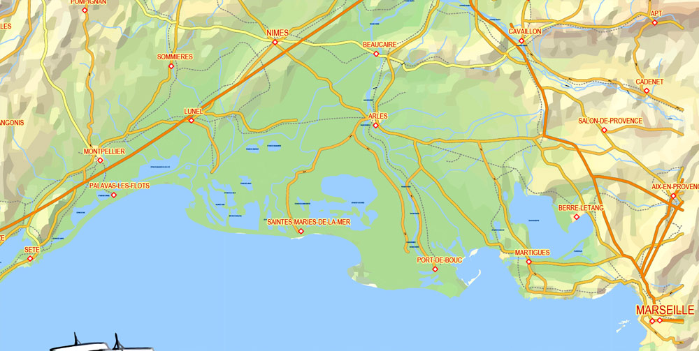
- Urban plan Marseille France
- Urban plan Shanghai China AI ENG LOW
- Urban plan Austria Vector Relief Roads
- Urban plan Portugal Admin
- Urban plan Zurich Switzerland
- Urban plan Copenhagen Kobenhavn Denmark pdf
- Urban plan Stockholm Sweden pdf
- Urban plan Karachi Pakistan
- Urban plan Pforzheim Germany pdf
- Urban plan UK Great Britain
- Urban plan Chicago Illinois ai
- Urban plan full Poland Relief
- Urban plan Santa Clara California
- Urban plan Madison Wisconsin
- Urban plan Sydney Australia 4
- Urban plan Czech Republic Roads Relief
- Urban plan Bordeaux France
- Urban plan UK Ireland PDF
- Urban plan Miami Florida PDF
- Urban plan Sydney Australia ZIP PDF
- Urban plan Derry Ireland
- Urban plan Edmonton PDF
- Urban plan Austria Admin
- Urban plan Calgary Canada PDF
- Urban plan Barnstable Massachusetts AI
- Urban plan Australia ZIPCODES
- Urban plan Santa Fe New Mexico PDF
- Urban plan Portland Oregon 25
- Urban plan Greensboro North Carolina
- Urban plan Texas Counties