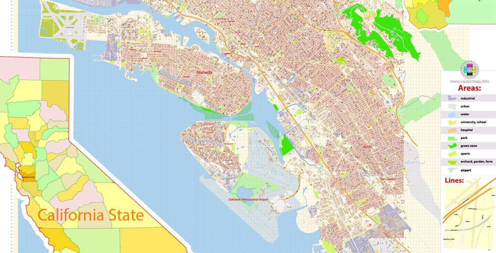
Urban plan Alameda Oakland California: Vector City Maps
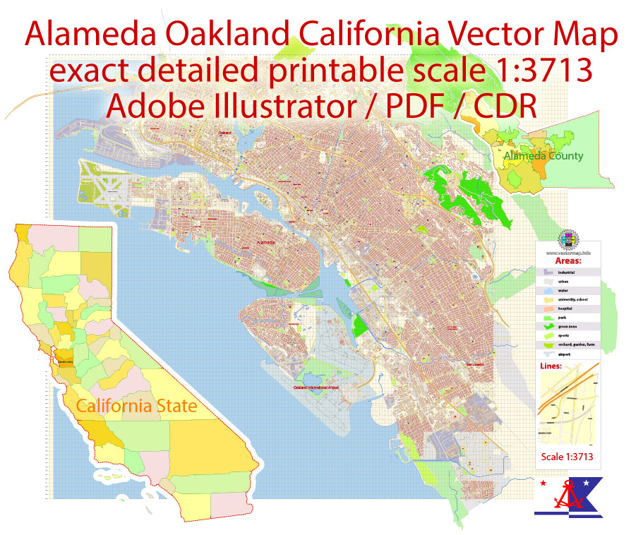
Alameda, California Digital Cartography


Oakland, California City Maps Editable Vector: AutoCAD DWG DXF, Adobe PDF, Illustrator and CorelDraw.


Urban plan Alameda Oakland California: Editable Maps for Business and Education
California, USA
The State of California, abbreviated CA, is a state in the western United States on the Pacific coast. It is the most populated and the 3rd largest state in the USA (after Alaska and Texas). Because of the sunny climate and the gold found here in 1848 ("Gold Rush"), California is sometimes called the "Golden State".
On the territory of the state of California, in Los Angeles, there is Hollywood, the 1st open Disneyland Park; the Golden Gate Bridge in San Francisco, the former prison, and now the Alcatraz Museum in San Francisco Bay; Silicon Valley in the northern part of the Santa Clara Valley. California is also famous for its vineyards and high-quality wine.
Area: 423970 km2 (of which 20037 km2 is the area of the water area)
Population: 36 million 457.5 thousand people. California is the most populous state in the USA: 4 largest cities are located here: Los Angeles (3 million 849 thousand 378 people), San Diego (1 million 257 thousand people), San Jose (929.9 thousand people), and San Francisco (744 thousand people)
Time Zone: Pacific Time Zone
The time difference between Washington and the East Coast is 3 hours.
Administrative center: Sacramento
California is a state located in the west of North America, on the Pacific coast. It is the third-largest U.S. state (after Alaska and Texas). The landscape of California is rich and diverse. Mountains, hills, canyons, and celestial peaks rising 4,600 meters above sea level, the Sierra Nevada Mountains surround the central California valley, separating it from the hot desert winds.
California has the lowest point of the geographical level, located in Death Valley, and the highest peak in the USA — Mount Whitney.
The state of California is characterized by moderately hot summers, warm winters, and an abundance of sunny days in all months of the year. It is a fertile land with a sea coast, mountain landscapes, orange groves, and vineyards.
But California is now far from being only an all-American orchard and movie kingdom, as it was at the beginning of the 20th century. Today, the names East and West Coast are not just geographical concepts. These words reflect a whole range of problems that characterize the trends in the development of the economic and political life of the country.
The East Coast is the part of the United States where "big business" began, where the American "establishment" was born. The East has long dictated its will to the country, directing its political and economic life. However, today California — the most populous state in America - often supplies more deputies to Congress than any other. This process is called the "Californication of America."
The very concept of the "far West" has changed. Now the West is associated not only with the "gold rush" of the middle of the last century, but also with oil, and in our time - with nuclear and space business, and with computer technology and information technology. Comparing the West and East coasts, the main thing should be noted: California has really pulled ahead today.
The name "California" was first given to these lands by the Spanish explorer Juan Rodriguez Cabrillo, who studied this North American Pacific coast in 1542. It is possible that the name Cabrillo gave to this coast came from a popular Spanish novel published in 1510, which told about a fictional paradise island called "California".
Traditionally, California is called the "golden state", meaning both its wonderful climate and blooming nature, and the gold found here.
Now this definition has been supplemented with a new meaning. California is really a "golden state" for the military-industrial complex. Here, Rockwell International, Lockheed, General Dynamics, and other corporations have placed the largest orders of the Pentagon. Most California firms work for the US Military. California is therefore called a "state within a state" and the "electronic brain of the nation."
However, the panorama of California will be incomplete, if not to say that it was here that the broad anti-war movement for nuclear freezing originated. There are many people among Californians who were the first to advocate for a lasting peace to finally be established on our planet.

Back in the late 18th – early 19th century, Franciscan monks began to teach local Indians the art of crafts and agriculture. At that time, the first small schools were established. However, most of the children of the local colonists were trained by private, home teachers.
The first school supported financially by the public and the city administration was opened in 1850 in San Francisco. Since 1849, the Constitution of the State of California has proclaimed the right to education. Therefore, all public schools in the state are funded by the California administration.
The state's educational system, consisting of many colleges and universities, is the largest in the United States. In the system of California State University alone, there are more than 20 colleges and higher schools, in which over 300 thousand people study. More than 165 thousand students live on nine campuses — university campuses. California State University is the largest in the USA.
The size of the state, its multilateral economy, and economic productivity, as well as the features of geographical relief, characterize California as a hyper-category state.
Among the fifty American states, California occupies a leading place in terms of the number of national parks and reserves. This is the only state in which unique giant sequoias grow.
Despite the vast mountainous territories of California, the economic life of the state is concentrated in the lower reaches of the valley, where four of the twenty largest US cities are located: Los Angeles, San Diego, San Jose, and San Francisco. The wealth of California is based on the diversity of the state's natural resources, a magnificent climate, and a large local population.
The richest agricultural region of the state - the Central Valley occupies 720 sq. km of fertile land in the center of California. It is here that the largest number of fruits, nuts, and vegetables are grown - nationwide. In addition, cotton, rice, and wheat are grown in the Valley. Farmers in the Central California Valley are also engaged in sheep farming and the meat and dairy industry.
The yield of fields and orchards of farmers in California is higher than in other states, and therefore the agricultural industry of this state is leading in many branches of agriculture nationwide.
California is also in first place in terms of the scale of annual construction of production facilities. The largest California cities are home to the production and laboratories of computer companies and the engineering industry, which are concentrated around universities located in these megacities.
In addition, this state has the largest population, the largest number of vehicles, civil aircraft, and the largest number of university and college students, compared to any other US state.
The factories of the southern and central districts of the state produce aerospace and electronic equipment. Deposits of oil and natural gas on the territory of California produce thousands of barrels of fuel per day, which makes it a leader among the mining states of the United States.
Gallery of Images "Urban plan Alameda Oakland California":
Urban Plans of California State: Digital City Maps


Oakland, California - Urban Plans in vector formats: Wall Art Printing


Urban Planning of Oakland and Alameda, California, high detailed


Oakland and Alameda, California, Fully Editable maps or Architect, Tourism, Logistics


- Urban plan Trenton New Jersey CDR
- Urban plan Namur Belgium ai
- Urban plan Sarajevo Bosnia Herzegovina ai
- Urban plan Israel Hebrew 17 AI
- Urban plan Bogota Metro Colombia
- Urban plan Sioux Falls South Dakota
- Urban plan Hanover Germany
- Urban plan Anchorage Alaska PDF
- Urban plan Santiago Chile
- Urban plan Yale University New Haven Connecticut PDF
- Urban plan Antwerpen Belgium ai
- Urban plan Geelong Australia
- Urban plan Providence Rhode Island
- Urban plan Beijing PDF
- Urban plan Haifa Israel pdf
- Urban plan Daytona Beach
- Urban plan Rybinsk
- Urban plan Dominican Republic Detailed PDF 125
- Urban plan Vladivostok PDF
- Urban plan Albuquerque NM
- Urban plan San Antonio
- Urban plan Edmonton Canada
- Urban plan Riga Latvia pdf
- Urban plan Leipzig Germany
- Urban plan full Poland 2
- Urban plan Saint Petersburg Tampa Florida
- Urban plan Toronto Billy Bishop
- Urban plan Cardiff Newport UK
- Urban plan Khabarovsk Russia
- Urban plan Adelaide Australia 17
- Urban plan Utrecht Netherlands pdf
- Urban plan Cannes France
- Urban plan Mexico Country Roads Relief
- Urban plan Kansas City Missouri PDF
- Urban plan New Orleans Louisiana
- Urban plan Winnipeg Canada PDF
- Urban plan Tallinn Estonia pdf
- Urban plan Kemerovo PDF Russia
- Urban plan Houston Texas PDF
- Urban plan World Political Roads CDR
- Urban plan Norway Admin
- Urban plan Kuala Lumpur Malaysia
- Urban plan Republica Dominicana y Haiti
- Urban plan Detroit Michigan
- Urban plan Charleroi Belgium ai
- Urban plan Syracuse New York
- Urban plan Leeds UK
- Urban plan Vancouver Canada
- Urban plan Nantes France
- Urban plan Smolensk pdf
- Urban plan Bratislava metro Slovakia PDF
- Urban plan Camden New Jersey
- Urban plan Tel Aviv Israel ai
- Urban plan Dublin Ireland ai
- Urban plan Palo Alto Mountain View California ai
- Urban plan Aarhus Denmark PDF
- Urban plan Biertan Romania PDF
- Urban plan Kelowna PDF
- Urban plan Rouen Metro France PDF
- Urban plan Krakow Poland
- Urban plan Miami Florida v309
- Urban plan Bridgeport Connecticut
- Urban plan Lille France pdf
- Urban plan Glasgow Scotland
- Urban plan Sydney Australia ZIP PDF
- Urban plan Columbia South Carolina PDF
- Urban plan Galway Ireland PDF
- Urban plan Zurich Switzerland
- Urban plan Princeton University Princeton New Jersey
- Urban plan Terre Haute Indiana ai
- Urban plan Singapore AI 15
- Urban plan Indianapolis PDF
- Urban plan Palo Alto Mountain View California pdf
- Urban plan Milwaukee Wisconsin ai
- Urban plan Dominican Republic Detailed AI
- Urban plan Luxembourg
- Urban plan Bremen Germany ai
- Urban plan Oxford UK
- Urban plan Spokane
- Urban plan Ballarat Australia 17
- Urban plan Sacramento California 17
- Urban plan Yuzhno Sakhalinsk pdf
- Urban plan Rio de Janeiro Brazil ai
- Urban plan Gdansk Poland CDR
- Urban plan Las Vegas Nevada 3 10 PDF
- Urban plan Netherlands Admin PDF
- Urban plan Batumi Georgia PDF
- Urban plan Madison Wisconsin PDF
- Urban plan Corrientes Resistencia PDF
- Urban plan Charleston South Carolina 3 10 CDR
- Urban plan Charleston South Carolina 3 10 PDF
- Urban plan Palermo Italy
- Urban plan Brownsville Harlingen Mcallen Texas PDF
- Urban plan Lisbon PDF
- Urban plan Monaco
- Urban plan Liege Belgium AI 13
- Urban plan Hong Kong Shenzhen China 13 PDF
- Urban plan San Juan Puerto Rico PDF
- Urban plan Charleston West Virginia
- Urban plan Beirut Lebanon ai
- Urban plan Nashville Tennessee PDF
- Urban plan Buffalo Niagara Falls StCatharines
- Urban plan admin Indonesia
- Urban plan Tulsa Oklahoma
- Urban plan Novokuznetsk PDF Russia
- Urban plan Montgomery Alabama
- Urban plan Belfast Ireland