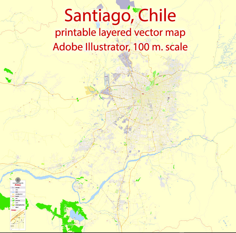
Urban plan Santiago Chile
Video "Urban plans Vector Map Works":
Urban Planning in Santiago Chile: Editable City Maps for Business and Education


Urban plan Santiago Chile
Santiago is the capital of the Republic of Chile, a state in the southwestern part of South America. The city is located in a wide valley between sandy hills at the foot of the Andes, at an altitude of about 540 m above sea level, on both banks of the Mapocho River. Santiago was founded in 1541 by the Spanish conquistador Pedro de Valdivia. The city is named after the Apostle St. James (in Spanish Santiago), who was considered the patron saint of Spain. In the colonial period from the XVI to the end of the XVIII century. Santiago was the residence of the Spanish Governor-General. After the declaration of independence of Chile in 1818, It became the capital of an independent republic and the seat of the President and Parliament of the country.
Santiago is one of the most beautiful cities in Latin America. Chileans themselves often call him the younger brother of Paris. There are many old churches and residential buildings of the colonial period with patios, portals, and metal grilles, standing next to modern multi-story buildings made of glass and concrete. The city has a rectangular layout.
Santiago is a very green city. It is crossed from east to west by the Mapocha River.
Main sights:
The attraction of the capital is the Santa Lucia hill, covered with trees and shrubs, dominating the central part of the city. It is decorated with a bronze statue of the Araucanian Indian chief Kaupolikan. The first house of the future city was laid on this hill. There is an extensive park on the hill, a chapel, and an ancient fortress have been built. On the right bank of the Mapocha River, San Cristobal Mountain rises with a giant 20-meter statue of the Madonna on top, spreading her arms over the city. A zoological garden is located on the slopes of the mountain.
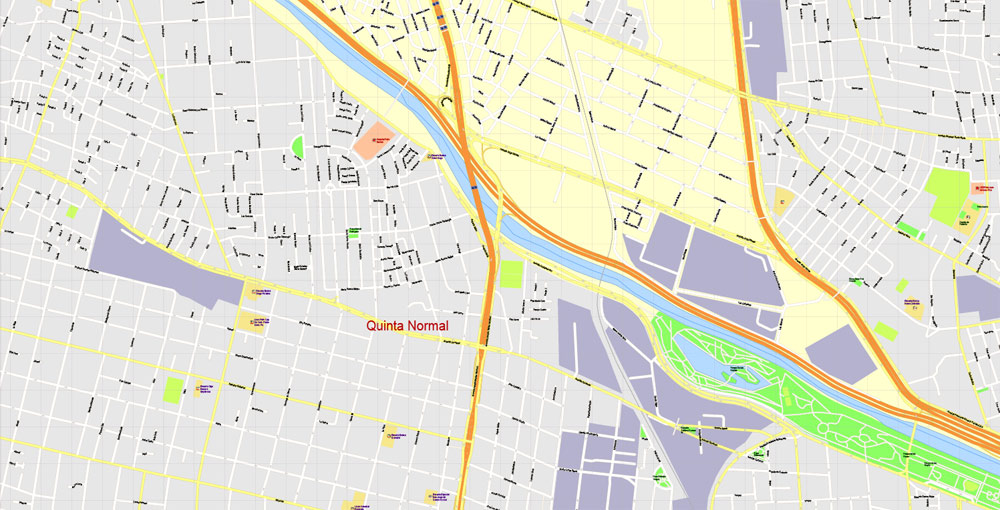
San Cristobal divides the city into two parts. To the right - the districts of Independencia, Recoleta, Salto, on the other side of the hill - Newnoa, Providencia. These are rich areas of the city, built up with mansions with swimming pools, squares, and alleys. Along the riverbank, there are many extensive shady parks and boulevards - "Bustamante", "Forest", "English", "Pedro de Valdivia", etc.
The blocks between the Mapocho River and the main, most beautiful street of the city, bearing the name of the national hero of the Chilean people Bernardo O'Higgins - the center (Alameda) of the Chilean capital. Here is the Plaza de Armas (Square of Arms), planted with century-old chestnuts. The cathedral, built-in 1780, the town hall, the Church of San Francisco, founded in 1572, is the oldest of the churches built in the capital by Spanish Catholics.
Monuments to the heroes of the struggle for independence of Chile: San Martin and Bernardo O'Higgins have been erected on Bulnes Square.
The Presidential Palace of La Moneda is located on La Constitucion Square. Not far from the palace are the buildings of the National Congress, the theaters "Imperio", "Teatro Municipal", the National Library, the State Archive.
The center of Santiago is called the Chilean City, it is the business center of the capital. Companies, banks, insurance companies are located in multi-story gray buildings.
The main shopping streets of the city are Estado, Ahumada, Agustinas. In the evenings, the city center turns into a place for walking.
The Central Market (Mercado Central) is a huge metal building made of galvanized iron, cast in England according to the project of Manuel Aldunate. The building was installed in 1868. You can buy anything at the market, starting with food and ending with items of national craft.
Santiago is the cultural center of the country. There are the Academy of Sciences, the University of Chile, founded in 1738, the Catholic University of Chile, existed since 1888, the National Conservatory, and a number of other educational institutions. The National Library of Chile was founded in 1813 . There are more than 10 theaters in the capital.
The creators of the city tried to plan it in such a way that the space between the city blocks and the Andes approaching Santiago was necessarily filled with parks. And if Santa Lucia Park was the first, then Metropolitano is one of the highest. The four hills on which the park is located rise above the city at an altitude of 800 meters.
To get up here, you can use the lift. The old station of the park funicular, similar to a European castle, is located at the foot of the mountain in the area of the Bario Bellavista quarter. This is one of the oldest neighborhoods in Santiago. He still retains his patriarchal appearance and way of life today.
Two-story mansions and old houses convey the unique atmosphere of old Santiago: shops, small hotels, cast-iron grilles drowning in flowers, quiet alleys, gray-haired caballeros strolling after breakfast. The hustle and bustle of the big city is somewhere out there - on the main street of Alameda or the pedestrian alley of Ahumada. And here the narrow streets come close to the foot of the San Cristobal Mountain. Some even crash into its spurs. The famous Chilean poet Pablo Neruda and his wife Matilda Urrutia built a house on one of these sites at one time. The house is literally cut into the rock. This structure looks very picturesque. It seems that the building is literally hanging on the wall or wants to climb up.

It only takes a few minutes to get to the top of the mountain. The lift has been working properly for decades. He lifted the first passengers to a height of almost a kilometer in 1925. Since then, day after day, he lifts everyone to the top, from where an excellent view of the city opens and where a thirty-six-meter white stone statue of the Virgin Mary rises.
There are many museums in the city. The National Historical Museum was founded in 1911 . Its exhibits tell about the history of Chile from the Spanish conquest to the present day.
Chile's art museums are interesting: the National Museum of Fine Arts, exhibiting paintings, graphics, sculptures, national and European art of the XVIII-XX centuries, the Museum of American Folk Art. The exposition of the Museum of Colonial Art presents works of art from Chile of the XVI-XIX centuries, mainly religious content. The Museum of Modern Art is interesting. It was opened in 1947 and has about 2000 works of art, which include such sections as painting, sculpture, graphics, photography. There are expositions of works by famous Chilean painters such as Nemesio Antunes and Guillermo Nunez and many others. The museum constantly hosts various exhibitions of contemporary European art.
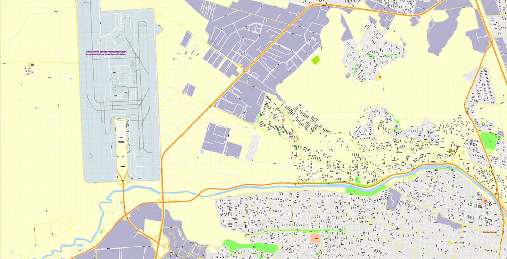
The capital of Chile, Santiago, is located in the Central Valley of the country and is considered part of the Metropolitan Region, which is called Greater Santiago. It is the largest city in Chile and the economic center of the country. All the state authorities of the country are concentrated here, with the exception of the legislative - the National Congress, which is located in Valparaiso.
The geographical position of Santiago is very specific — the city is located at the foot of the Andes on the banks of the Mapocho River in a closed basin. From the east, the capital is surrounded by the mountain ranges of the Andes, in the west it borders the coastal Cordillera.
Santiago confidently leads among other cities in Latin America in many respects: it is believed that here is the highest standard of living and security on the entire Latin American continent. As of 2021, the population of Greater Santiago, which includes 37 communes, is 6,573,737 people. The ethnic composition is quite homogeneous, especially compared to other South American countries.
Related Images "Urban plan Santiago Chile":
Urban Plans South America Chile Metro de Santiago: Digital Cartography
Santiago Chile Travel Maps for Printing in Adobe Illustrator and PDF
Urban Transport, Urban Expansion and Institutions in Santiago: Vector Maps


- Urban plan Beirut Lebanon pdf
- Urban plan Leeds UK
- Urban plan Kazan PDF Russia
- Urban plan Brisbane Australia 17
- Urban plan Veracruz Mexico
- Urban plan Montreal Grande area Canada
- Urban plan Oklahoma City PDF
- Urban plan Austin Texas PDF
- Urban plan Toledo Spain pdf
- Urban plan Liege Grande Belgium PDF
- Urban plan Rio de Janeiro Brazil
- Urban plan Victoria Canada AI
- Urban plan Chicago Illinois ai
- Urban plan Roads Dominicana
- Urban plan Paris Grande
- Urban plan Santo Domingo
- Urban plan London Center
- Urban plan Calgary Canada
- Urban plan Edmonton PDF
- Urban plan Copenhagen Kobenhavn Denmark PDF low
- Urban plan Finland Admin
- Urban plan Sarajevo Bosnia Herzegovina ai
- Urban plan Vladivostok
- Urban plan Dublin Ireland PDF
- Urban plan Hobart Tasmania PDF
- Urban plan Cherepovets pdf
- Urban plan Washington DC pdf
- Urban plan Burlington Vermont
- Urban plan Adelaide Australia 17
- Urban plan Oakland Berkeley Richmond Alameda San Leandro Albany CDR
- Urban plan Wollongong Australia PDF
- Urban plan Poland Admin
- Urban plan Barnstable Massachusetts AI
- Urban plan Perth Australia
- Urban plan Washington DC
- Urban plan Hobart Tasmania 3 10 PDF
- Urban plan Bergen Norway pdf
- Urban plan Albury Wodonga Australia PDF 17
- Urban plan Omaha Nebraska PDF
- Urban plan Richmond Virginia
- Urban plan Wellington New Zealand 3 11 Ai
- Urban plan Voronezh PDF
- Urban plan Travis County Austin Texas PDF
- Urban plan Eugene Oregon 3 10
- Urban plan Cleveland Chio
- Urban plan Aarhus Denmark
- Urban plan Salem Oregon PDF
- Urban plan Kharkiv Ukraine CDR
- Urban plan Bridgeport Connecticut
- Urban plan Christchurch New Zealand
- Urban plan Geelong Australia
- Urban plan Flags Countries
- Urban plan Pittsburgh Pennsylvania
- Urban plan Bogota Metro Colombia
- Urban plan Santiago Chile
- Urban plan Cairns Australia PDF 17
- Urban plan Austria Vector Relief Roads
- Urban plan Munchen Germany
- Urban plan Quebec City Canada ai 17
- Urban plan San Antonio Texas ai
- Urban plan Lagos Nigeria
- Urban plan San Francisco Oakland California PDF
- Urban plan Toronto Billy Bishop PDF
- Urban plan Krakow Poland
- Urban plan Cannes Area France PDF
- Urban plan Massachusetts State PDF