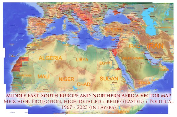
The Middle East is a region that spans parts of three continents: Asia, Africa, and Europe. It is a transcontinental region located at the crossroads of Asia and Africa, and it holds great historical, cultural, and geopolitical significance. The Middle East is characterized by a diverse landscape, which includes deserts, mountains, plateaus, and fertile plains.
Vectormap.Net provide you with the most accurate and up-to-date vector maps in Adobe Illustrator, PDF and other formats, designed for editing and printing. Please read the vector map descriptions carefully.
Here is a detailed description of the geography and nature of the Middle East:
- Deserts:
- Rub’ al Khali (Empty Quarter): One of the largest continuous sand deserts in the world, spanning parts of Saudi Arabia, Oman, the United Arab Emirates, and Yemen. It is known for its vast, uninterrupted sand dunes.
- Arabian Desert: Encompassing much of the Arabian Peninsula, it is a vast expanse of arid terrain with rocky plateaus, gravel plains, and sand dunes.
- Mountains:
- Zagros Mountains: Stretching across western Iran and eastern Iraq, the Zagros Mountains form a natural barrier between the Iranian Plateau and the Mesopotamian plain.
- Taurus Mountains: Located in southern Turkey, they extend into Syria. These mountains are known for their rugged terrain and serve as a natural boundary between the Anatolian Plateau and the coastal regions.
- Hajar Mountains: Running through the eastern Arabian Peninsula, primarily in Oman and the United Arab Emirates, these mountains have rocky slopes and deep valleys.
- Plateaus:
- Anatolian Plateau: Located in Turkey, this plateau is surrounded by mountain ranges and has a mix of agricultural land and steppe.
- Iranian Plateau: A vast elevated region covering much of Iran, it is characterized by plateaus and mountains, including the Central Iranian Plateau and the Dasht-e Kavir and Dasht-e Lut salt deserts.
- Rivers:
- Tigris and Euphrates: These rivers flow through Iraq and parts of Turkey, forming the historic region of Mesopotamia. They have been crucial for the development of ancient civilizations like the Sumerians and Babylonians.
- Fertile Plains:
- Nile Delta: Though the main course of the Nile River is in Africa, the delta extends into the northeastern part of the Middle East, providing fertile land in Egypt.
- Mesopotamian Plain: Formed between the Tigris and Euphrates rivers, it is often referred to as the “cradle of civilization” due to the emergence of ancient civilizations such as Sumer and Akkad.
- Seas and Water Bodies:
- Mediterranean Sea: Borders the Middle East to the northwest, influencing the climate and supporting maritime activities.
- Red Sea: Separates the Arabian Peninsula from Northeast Africa, connecting to the Gulf of Aden and the Indian Ocean.
- Climate:
- The Middle East experiences a range of climates, from the hot desert climate in the Arabian Desert to a Mediterranean climate along the coastal areas and highland climates in mountainous regions.
- Biodiversity:
- The region’s diverse geography contributes to a variety of ecosystems and biodiversity. However, some areas, particularly deserts, have limited vegetation and wildlife adapted to arid conditions.
The Middle East’s geography has played a crucial role in shaping its history, influencing trade routes, and contributing to the development of ancient civilizations. Today, it remains a region of strategic importance with a rich cultural heritage.


 Author: Kirill Shrayber, Ph.D. FRGS