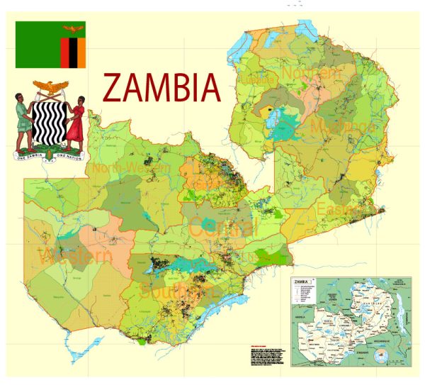
Zambia is a landlocked country in Southern Africa known for its diverse landscapes, wildlife, and vibrant culture.
Vectormap.Net provide you with the most accurate and up-to-date vector maps in Adobe Illustrator, PDF and other formats, designed for editing and printing. Please read the vector map descriptions carefully.
Here’s a detailed overview of some of its main cities, nature parks, water areas, and principal roads:
Main Cities:
- Lusaka:
- The capital and largest city of Zambia.
- Economic and political hub of the country.
- Features modern amenities, government buildings, and a mix of traditional and contemporary architecture.
- Ndola:
- The second-largest city and an important economic center.
- Known for its mining and industrial activities.
- Has a well-developed infrastructure and is a major transportation hub.
- Kitwe:
- Third-largest city and an important part of the Copperbelt Province.
- Like Ndola, it is associated with mining activities.
- Has a mix of urban and industrial areas.
- Livingstone:
- A tourist hub near Victoria Falls.
- Named after the famous explorer David Livingstone.
- Offers a gateway to the Zambezi River and the Mosi-oa-Tunya National Park.
Nature Parks and Wildlife Reserves:
- South Luangwa National Park:
- One of the most famous wildlife reserves in Africa.
- Home to diverse flora and fauna, including elephants, hippos, and various bird species.
- Offers excellent opportunities for safari experiences.
- Lower Zambezi National Park:
- Situated along the Zambezi River.
- Known for its stunning landscapes, rich wildlife, and river activities like canoe safaris.
- Features a variety of animals, including elephants, lions, and leopards.
- Kafue National Park:
- The largest national park in Zambia.
- Offers a diverse range of ecosystems, from grassy plains to woodlands.
- Home to numerous wildlife species, including cheetahs, leopards, and antelopes.
Water Areas:
- Victoria Falls:
- One of the most famous natural wonders and a UNESCO World Heritage Site.
- Located on the border between Zambia and Zimbabwe.
- Offers breathtaking views of the Zambezi River plunging into the Batoka Gorge.
- Lake Kariba:
- One of the world’s largest man-made lakes.
- Formed by the damming of the Zambezi River.
- Popular for fishing, boating, and wildlife watching along its shores.
Principal Roads:
- Great North Road:
- Connects Lusaka to the Copperbelt region.
- An important transportation route for both passengers and goods.
- T2 Road:
- Connects Lusaka to Livingstone.
- Provides access to Victoria Falls and the border with Zimbabwe.
- T4 Road:
- Links Lusaka with the eastern part of the country, including Chipata and the Malawi border.
- T1 Road:
- Connects Lusaka to the northern part of Zambia, including Ndola and the Tanzanian border.
These are just a few highlights, and Zambia has many more natural wonders, parks, and cities waiting to be explored. The country’s diverse landscapes and rich biodiversity make it a unique destination for both nature enthusiasts and adventure seekers.


 Author: Kirill Shrayber, Ph.D. FRGS