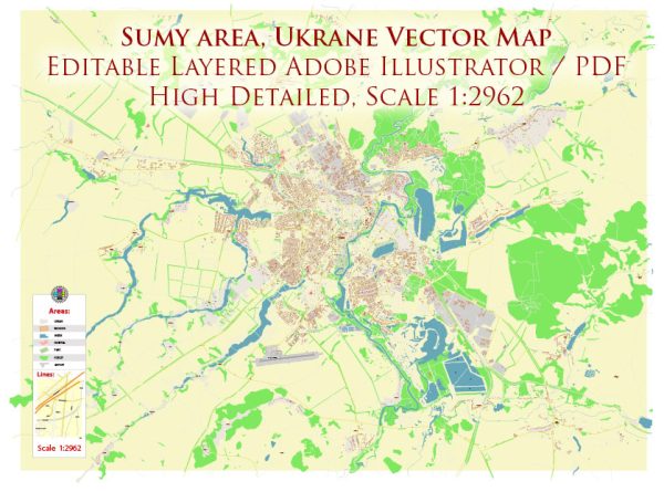
A general overview of Sumy, Ukraine, including its districts, communities, and main streets.
Vectormap.Net provide you with the most accurate and up-to-date vector maps in Adobe Illustrator, PDF and other formats, designed for editing and printing. Please read the vector map descriptions carefully.
Sumy Overview: Sumy is a city located in northeastern Ukraine and serves as the administrative center of the Sumy Oblast. It is situated on the Psel River, a tributary of the Dnieper. The city has a rich history and is known for its cultural heritage, educational institutions, and industrial presence.
Districts and Communities:
- City Center: The central part of Sumy is often considered the heart of the city, containing historical and cultural landmarks, government buildings, and commercial areas.
- Soborna District: This district is characterized by the Soborna Street and surrounding areas, hosting residential and commercial spaces.
- Zarechny District: Situated on the left bank of the Psel River, this district includes residential neighborhoods and is known for its green spaces.
- Pidhirya District: Located on the right bank of the Psel River, Pidhirya is a predominantly residential area with various amenities.
- Kharkivska District: This district encompasses the southeastern part of Sumy and is known for its industrial and business zones.
- Shevchenkivskyi District: Named after the famous Ukrainian poet Taras Shevchenko, this district is home to educational institutions and residential areas.
Main Streets:
- Myru Avenue (Avenue of Peace): A central avenue in Sumy, often bustling with activity, featuring shops, cafes, and cultural venues.
- Kharkivska Street: Running through the Kharkivska District, this street is likely to have a mix of residential and commercial properties.
- Soborna Street: Located in the Soborna District, this street is significant for its historical buildings, shops, and restaurants.
- Voskresenska Street: Known for its historical and architectural landmarks, this street is part of the city center and is lined with various establishments.
- Petropavlivska Street: Running through different districts, this street may offer a mix of residential and commercial spaces.
- Rymskoho-Korsakova Street: Another important street in Sumy, it is likely to have a variety of services, businesses, and residential areas.
Please note that the information provided here is a general overview, and for the most accurate and up-to-date details, it is advisable to consult local sources or official city maps.


 Author: Kirill Shrayber, Ph.D. FRGS