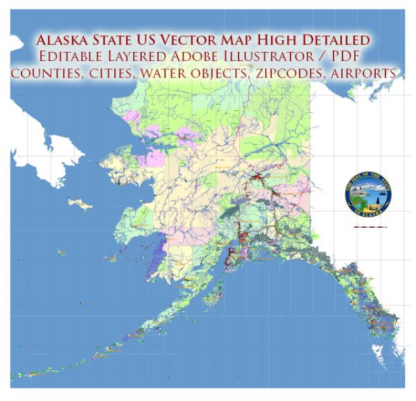
Alaska, the largest state in the United States, is known for its vast and diverse landscapes, including mountains, glaciers, and wilderness areas. The state is characterized by its unique geography, with numerous rivers, lakes, and mountain ranges. Here’s a description of some principal cities, waterways, and main roads in Alaska:
Principal Cities:
- Anchorage: Located in the south-central part of the state, Anchorage is the largest city in Alaska. It serves as a major economic and cultural hub, with a diverse population and access to outdoor recreational activities.
- Fairbanks: Situated in the interior of Alaska, Fairbanks is known for its cold winters and is a center for mining, transportation, and tourism. It is also home to the University of Alaska Fairbanks.
- Juneau: The capital city of Alaska, Juneau is located in the southeastern part of the state. It is the only U.S. capital inaccessible by road and is known for its stunning scenery, including glaciers and mountains.
- Sitka: Another city in southeastern Alaska, Sitka is known for its Russian history and cultural heritage. It offers a mix of outdoor activities and historical sites.
- Ketchikan: Located in the southernmost part of Alaska, Ketchikan is known for its scenic location along the Inside Passage. It’s a popular stop for cruise ships and offers opportunities for outdoor adventures.
Waterways:
- Yukon River: One of the longest rivers in North America, the Yukon River flows through the central part of Alaska. It has played a significant role in the state’s history, particularly during the Klondike Gold Rush.
- Tanana River: Running through the interior of Alaska, the Tanana River is a major tributary of the Yukon River. It passes through Fairbanks and supports various wildlife habitats.
- Copper River: This river flows through south-central Alaska and is known for its rich salmon fisheries. The Copper River Highway provides access to some scenic viewpoints along the river.
- Inside Passage: A coastal route along southeastern Alaska, the Inside Passage is famous for its stunning fjords, glaciers, and diverse marine life. It is a popular route for cruise ships.
Main Roads:
- Alaska Highway (Alcan Highway): Starting in Dawson Creek, British Columbia, Canada, the Alaska Highway extends into Alaska, providing a crucial road link to the contiguous United States.
- Seward Highway: Connecting Anchorage to the port city of Seward, this highway offers breathtaking views of mountains, glaciers, and wildlife along the way.
- George Parks Highway: Stretching from Anchorage to Fairbanks, this highway provides access to Denali National Park and other scenic areas in the interior.
- Richardson Highway: Running from Valdez to Fairbanks, the Richardson Highway offers access to the interior and passes through picturesque landscapes, including the Alaska Range.
These are just a few highlights, and Alaska’s vast and diverse terrain offers many more notable cities, waterways, and roads waiting to be explored.
Transportation
High costs of transportation continue to sap Alaska’s economic development, largely because the major transportation links,
both internal and external, are by air, which provides the fastest way to cross Alaska’s great distances and formidable terrain.
Vectormap.Net provide you with the most accurate and up-to-date vector maps in Adobe Illustrator, PDF and other formats, designed for editing and printing. Please read the vector map descriptions carefully.
Numerous national airlines serve Alaska, and there are international airports at Anchorage, Fairbanks, Juneau, and Ketchikan.
There are several other local airports of significance and hundreds of landing strips. In the 1990s Alaska became a
central point for long-distance air cargo shipment connecting Asia, the United States, and Europe, and many American
and European cargo airlines now fly through Anchorage and Fairbanks.
Most of the state’s major highways are surfaced, but gravel roads still exist. The Dalton Highway,
a 414-mile (666-km) road paralleling the Trans-Alaska Pipeline, runs from Fairbanks to Prudhoe Bay
and combines with the existing highway system to provide an overland route from the ice-free southern
ports to the Arctic Ocean. The highway becomes more remote and rugged as it heads north, and the public
is restricted in its use of that highway north of Disaster Creek (211 miles [340 km] from its starting point).
The Alaska Highway was built during World War II and has been significantly improved by both Canada and the United States.
It connects Dawson Creek, British Columbia, with Fairbanks.
Ocean shipping connects Seattle, Vancouver, and the trans-Canada railhead of Prince Rupert to towns
in the panhandle and westward to the towns of Cordova, Valdez, Seward, and Kodiak. During the ice-free midsummer months,
oceangoing vessels also call in Nome, Barrow, and Prudhoe Bay. Anchorage is Alaska’s major port for imports,
while petroleum is exported from Kenai and Valdez, and fish are exported from southeast port cities,
particularly Kodiak and Unalaska.
The Alaska Marine Highway (1963) is a ferry system with passenger and vehicle service that runs from Bellingham,
Washington, or Prince Rupert, British Columbia, northward across the Gulf of Alaska, into Prince William Sound,
and onto the Aleutian chain, making stops in more than 30 coastal towns and cities along the way. Many tourists
take the ferries and disembark at Haines or Skagway, inland communities that provide access to highways where
they can drive their vehicles farther into the mainland.
The state-owned and state-operated Alaska Railroad runs for about 500 miles (800 km), linking Seward,
Anchorage, and Fairbanks. The White Pass and Yukon Route Railway (1898) operates from May through September
and travels from Skagway into the Yukon territory.


 Author: Kirill Shrayber, Ph.D.