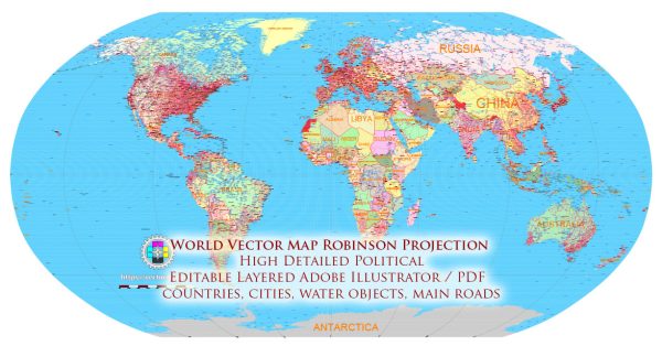
The Robinson projection is a map projection that was developed by American cartographer Arthur H. Robinson in 1963. This projection is an attempt to balance the various types of distortions found in other map projections, making it suitable for creating world maps that aim to provide a more visually pleasing and balanced representation of the Earth’s surface. The Robinson projection is a compromise projection, designed to minimize distortions in size, shape, and distance across the entire map.
Here’s a brief history of the creation of the Robinson projection:
- Arthur H. Robinson (1915-2004): Arthur H. Robinson was an influential American cartographer and geographer. He was a professor at the University of Wisconsin-Madison and later at Harvard University. Throughout his career, Robinson was concerned with the problem of map projections and wanted to develop a map that could better represent the Earth’s surface without extreme distortions.
- Development of the Projection: Arthur Robinson started working on what would later become the Robinson projection in the 1950s. He wanted to create a world map that struck a balance between different types of distortion, such as area, shape, and distance. The result was the Robinson projection, which he introduced in a 1963 article titled “A New Map Projection: Its Development and Characteristics” in the journal “The International Yearbook of Cartography.”
- Characteristics: The Robinson projection is an example of a pseudocylindrical projection, which means that it approximates a cylinder, but the meridians (lines of longitude) are not straight lines. Instead, they curve gently. The projection is particularly well-suited for world maps because it minimizes distortions across the entire map, making it a compromise projection.
- Widespread Adoption: The Robinson projection gained popularity and became widely used in the 20th century for general world maps. It was used by organizations such as National Geographic and various atlases and continues to be employed in many educational materials and publications.
- Critiques and Alternatives: While the Robinson projection is a significant improvement over some earlier projections in terms of balancing distortions, it is not free from criticism. Map enthusiasts and cartographers continue to explore and develop other projections that may provide better solutions for specific purposes or regions. There is no one-size-fits-all projection, and the choice of a projection depends on the intended use of the map.
In summary, the Robinson projection was developed by Arthur H. Robinson in the 1960s as a compromise map projection that attempts to minimize various types of distortions found in other projections. It has been widely used in world maps and educational materials for its ability to provide a more visually appealing and balanced representation of the Earth’s surface.


 Author: Kirill Shrayber, Ph.D. FRGS