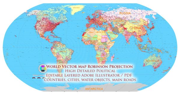
The Robinson projection is a map projection that was developed by Arthur H. Robinson in 1961. It is designed to provide a compromise between various map properties, making it a more suitable choice for world maps than some other projections. Here are the key features of the Robinson projection:
- Pseudo-Cylindrical Projection: The Robinson projection is a pseudo-cylindrical projection, which means that it combines elements of both cylindrical and pseudocylindrical projections. It attempts to balance the preservation of size, shape, and angles to create a visually pleasing and useful world map.
- Minimal Distortion: One of the main objectives of the Robinson projection is to minimize distortion across the entire map. While it doesn’t preserve any one property perfectly, it aims to provide a good compromise by minimizing distortions in size, shape, and distance over the entire map.
- Oval World Shape: The Robinson projection represents the Earth as an oval shape, rather than a perfect circle. This helps to reduce the stretching of land masses in high latitudes and the polar regions compared to some other projections.
- Rounded and Smooth Meridians: Unlike the straight meridians of the Mercator projection, the Robinson projection features gently curving meridians, which provides a more realistic representation of the Earth’s surface.
- Equal Spacing of Parallels: Parallels of latitude on the Robinson projection are equally spaced, which helps maintain some sense of proportion and balance in the map.
- Suitable for General Reference: The Robinson projection is often used in world maps designed for general reference purposes, such as world atlases and educational materials. It offers a more aesthetically pleasing representation of the world compared to some other projections.
- Reduced Polar Distortion: While no projection can entirely eliminate distortion, the Robinson projection reduces the extreme distortions seen in polar regions on some other projections like the Mercator. This makes it a better choice for showing the entire world, including the polar areas.
- Latitude Limits: The Robinson projection is typically limited to latitudes between 80 degrees north and 80 degrees south. Beyond these limits, the distortion becomes significant.
- Graticule Grid: The Robinson projection uses a grid of equally spaced parallels and gently curved meridians, making it easier to locate and measure distances and angles on the map.
- Popular in Educational Materials: This projection is commonly found in school textbooks and world maps because it provides a more balanced representation of the world than some other projections while remaining visually appealing.
In summary, the Robinson projection is a compromise projection that aims to minimize distortions in size, shape, and distance across the entire map. It is often used in world maps for educational and general reference purposes and provides a more realistic portrayal of the Earth’s surface than some other projections, particularly in high latitudes and polar regions.


 Author: Kirill Shrayber, Ph.D.