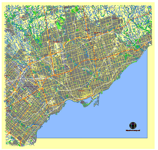
Editable Vector Map of the Toronto Canada in SVG format.
Can be edited in the following programs: Adobe Illustrator, CorelDraw, InkScape
Principal streets and roads, names places, residential streets and roads, road number labels, water objects, land use areas.
Toronto Canada editable vector map svg free
DOWNLOAD ARCHIVE FOR FREE >>>
Distributed with Creative Commons CC-Zero = Creative Commons CC0 1.0 Universal Public Domain Dedication International License
SEE ALSO FULL VERSION OF THE Toronto Canada vector map (Adobe Illustrator, PDF etc.)
Toronto, Canada, is a bustling metropolis with numerous streets, roads, and distinct districts that each offer a unique character and experience. Here’s an overview of some principal streets, roads, and key districts:
Principal Streets and Roads
- Yonge Street:
- Often referred to as the spine of Toronto, it runs north-south and is one of the longest streets in the world.
- Major commercial thoroughfare with shops, restaurants, and landmarks like the Eaton Centre.
- Bloor Street:
- Runs east-west and is known for its upscale shopping district in Yorkville, the University of Toronto campus, and cultural institutions.
- Queen Street:
- A major east-west street, famous for its vibrant arts and culture scene, shopping, and entertainment.
- Home to the Queen Street West district, known for its trendy shops, restaurants, and nightlife.
- King Street:
- Another key east-west street, King Street is at the heart of the Financial District.
- Known for its theatres, restaurants, and nightlife, especially in the King West area.
- Bay Street:
- The center of Toronto’s Financial District, running north-south.
- Known for its concentration of banks, corporate headquarters, and law firms.
- Danforth Avenue:
- Runs east-west and is known for its vibrant Greektown, with numerous Greek restaurants, shops, and annual festivals.
- Spadina Avenue:
- Runs north-south, connecting Chinatown, Kensington Market, and the Annex.
- University Avenue:
- A major north-south street that runs through the Financial District and past major hospitals and the Ontario Legislative Building.
Key Districts
- Downtown Toronto:
- The commercial and cultural heart of the city.
- Includes the Financial District, Entertainment District, and areas around Yonge-Dundas Square.
- The Annex:
- A vibrant neighborhood known for its historic homes, student population, and proximity to the University of Toronto.
- Kensington Market:
- A diverse and eclectic area known for its markets, vintage shops, and multicultural food offerings.
- Yorkville:
- An upscale neighborhood known for high-end shopping, luxury hotels, and fine dining.
- Chinatown:
- One of the largest Chinatowns in North America, with a plethora of Chinese and Asian restaurants, shops, and markets.
- Distillery District:
- A historic and pedestrian-only district known for its well-preserved Victorian industrial architecture, art galleries, and boutique shops.
- Liberty Village:
- A rapidly developing area with a mix of residential lofts, office spaces, and trendy eateries.
- Queen West:
- Known for its vibrant arts and culture scene, including galleries, music venues, and independent boutiques.
- Cabbagetown:
- A historic neighborhood with Victorian homes, parks, and a strong community vibe.
- The Beaches:
- Located in the eastern part of the city, known for its sandy beaches, boardwalk, and quaint shops along Queen Street East.
- St. Lawrence Market:
- A historic market district known for its food market, artisanal goods, and proximity to the historic St. Lawrence Hall.
- Leslieville:
- Known for its village-like atmosphere, with boutique shops, cafes, and a strong sense of community.
Each of these streets and districts contributes to the rich tapestry that makes Toronto a dynamic and diverse city.
 Author: Kirill Shrayber, Ph.D. FRGS