Editable Vector Map of the Sydney Australia in SVG format.
Can be edited in the following programs: Adobe Illustrator, CorelDraw, InkScape
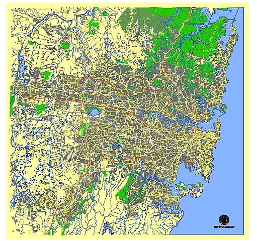
Principal streets and roads, names places, residential streets and roads, road number labels, water objects, land use areas.
Sydney Australia editable vector map svg free
DOWNLOAD ARCHIVE FOR FREE >>>
Distributed with Creative Commons CC-Zero = Creative Commons CC0 1.0 Universal Public Domain Dedication International License
SEE ALSO FULL VERSION OF THE Sydney Australia vector map (Adobe Illustrator, PDF etc.)
Sydney, Australia, is a vibrant city with several key streets, roads, and districts that define its urban landscape. Here are some of the principal ones:
Streets and Roads:
- George Street – One of Sydney’s oldest streets, running through the central business district (CBD). It is known for shopping, entertainment, and historical landmarks.
- Oxford Street – Famous for its nightlife, LGBTQ+ community presence, and boutique shopping, located in the inner east suburbs.
- Pitt Street Mall – A pedestrianized shopping street in the heart of Sydney’s CBD, lined with major retail stores and cafes.
- Circular Quay – While primarily a waterfront area, Circular Quay connects several key streets such as Alfred Street and George Street, offering stunning views of the Sydney Opera House and Sydney Harbour Bridge.
- Anzac Parade – A major road in Sydney connecting the CBD to the southeastern suburbs, notable for its wide boulevard-style layout and significant landmarks.
- Bondi Road – Leading to the iconic Bondi Beach, this street is a mix of cafes, shops, and residential areas in the eastern suburbs.
City Districts:
- Central Business District (CBD) – The financial and economic heart of Sydney, with skyscrapers, shopping precincts, and cultural institutions like the Museum of Contemporary Art.
- The Rocks – A historic district near Circular Quay known for its cobblestone streets, heritage buildings, markets, and pubs.
- Darling Harbour – A bustling entertainment and dining precinct with attractions like the Sydney Aquarium and Madame Tussauds.
- Surry Hills – A trendy inner-city suburb known for its cafes, bars, and cultural diversity.
- Paddington – Characterized by its Victorian terrace houses, Paddington is renowned for boutique shopping, markets, and galleries.
- Newtown – A bohemian suburb known for its alternative culture, street art, live music venues, and diverse dining options.
- Bondi Beach – Australia’s most famous beach, offering surfing, sunbathing, and a lively beachfront scene.
- Manly – A beachside suburb accessible by ferry, known for its surf culture, scenic walks, and relaxed atmosphere.
These streets, roads, and districts collectively showcase the diversity and liveliness that Sydney has to offer, from bustling urban centers to relaxed beachside communities.
 Author: Kirill Shrayber, Ph.D. FRGS