Editable Vector Map of the Pierre South Dakota US in SVG format.
Can be edited in the following programs: Adobe Illustrator, CorelDraw, InkScape
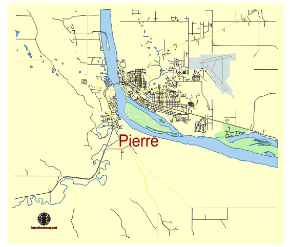
Principal streets and roads, names places, residential streets and roads, road number labels, water objects, land use areas.
Pierre South Dakota US vector map svg free
DOWNLOAD ARCHIVE FOR FREE >>>
Distributed with Creative Commons CC-Zero = Creative Commons CC0 1.0 Universal Public Domain Dedication International License
SEE ALSO FULL VERSION OF THE Pierre South Dakota US vector map (Adobe Illustrator, PDF etc.)
Pierre, the capital city of South Dakota, has a variety of principal streets, roads, and districts that contribute to its layout and functionality. Here’s an overview:
Principal Streets and Roads
- Capitol Avenue: This is one of the main streets in Pierre, leading directly to the South Dakota State Capitol. It is lined with various government buildings and is a significant thoroughfare in the city.
- Pierre Street: A central street in downtown Pierre, known for its local businesses, shops, and restaurants.
- Harrison Avenue: Another important street that runs parallel to Capitol Avenue, providing access to residential areas and local amenities.
- Euclid Avenue: This street is a major north-south artery in the city, connecting various neighborhoods and commercial areas.
- Sioux Avenue: A major east-west street that runs through the heart of Pierre, providing access to both residential and commercial zones.
- Dakota Avenue: Known for being a significant road in the city, providing access to various important locations.
- Garfield Avenue: Another key street that connects different parts of the city.
Key Districts
- Downtown Pierre: The downtown area is the commercial heart of the city, featuring a mix of shops, restaurants, and businesses. It includes important streets like Pierre Street and Capitol Avenue.
- Capitol Complex: This district is home to the South Dakota State Capitol and various government offices. It is a central point of interest and activity in Pierre.
- Residential Neighborhoods: Pierre has several residential neighborhoods, including areas around Harrison Avenue, Euclid Avenue, and Sioux Avenue, providing housing for the city’s population.
- Riverfront District: Located along the Missouri River, this district features parks, recreational areas, and scenic views, contributing to the city’s leisure and tourism appeal.
- Commercial Zones: Spread throughout the city, these zones include shopping centers, restaurants, and service providers, mainly concentrated along major streets like Sioux Avenue and Euclid Avenue.
- Historic Districts: Certain areas in Pierre are recognized for their historical significance, with preserved buildings and landmarks that reflect the city’s heritage.
These principal streets, roads, and districts form the backbone of Pierre, facilitating transportation, commerce, governance, and residential life.
 Author: Kirill Shrayber, Ph.D. FRGS