Editable Vector Map of the Liege Belgium in SVG format.
Can be edited in the following programs: Adobe Illustrator, CorelDraw, InkScape
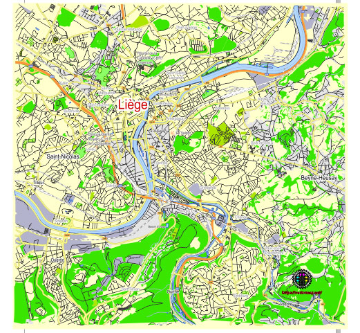
Principal streets and roads, names places, residential streets and roads, road number labels, water objects, land use areas.
Liege Belgium editable vector map svg free
DOWNLOAD ARCHIVE FOR FREE >>>
Distributed with Creative Commons Attribution 4.0 International License
SEE ALSO FULL VERSION OF THE Liege Belgium vector map (Adobe Illustrator, PDF etc.)
Liège, a major city in the French-speaking region of Belgium, is rich in history and culture. It boasts numerous principal streets, roads, and districts, each contributing to the city’s unique character. Here are some key details:
Principal Streets and Roads
- Boulevard d’Avroy: A central boulevard in Liège, known for its green spaces and proximity to the Parc d’Avroy.
- Rue de la Régence: A major street lined with shops, restaurants, and significant buildings.
- Quai de Rome: A notable quay along the Meuse River, offering scenic views and access to the waterfront.
- Rue Léopold: Another central street with commercial and residential significance.
- Boulevard de la Sauvenière: A prominent boulevard in the city center, known for its theaters and nightlife.
- Rue Saint-Gilles: A busy street that connects various parts of the city and features a mix of residential and commercial properties.
- Quai Churchill: Another key quay along the Meuse River, known for its beautiful views and strategic location.
Principal Districts
- Centre (City Center): The historic heart of Liège, home to many of the city’s major landmarks, including the Place Saint-Lambert, the Liège Cathedral, and the Opéra Royal de Wallonie.
- Outremeuse: A lively district on an island in the Meuse River, known for its cultural events, including the famous annual festival “15 août en Outremeuse”.
- Sainte-Marguerite: A residential area with a mix of old and new architecture, and local markets.
- Saint-Léonard: Known for its historical sites and vibrant community, featuring the Saint-Léonard Church and several local businesses.
- Amercoeur: A district that has a mix of industrial and residential areas, reflecting Liège’s industrial heritage.
- Bressoux: Located east of the city center, this district is predominantly residential with a range of amenities.
- Féronstrée and Hors-Château: Historic districts with cobblestone streets and significant architectural landmarks.
- Guillemins: Known for the Liège-Guillemins railway station, designed by the renowned architect Santiago Calatrava, and serving as a major transportation hub.
- Saint-Walburge: A hilly district offering panoramic views of the city and home to the Church of Saint-Walburge.
- Longdoz: A commercial district with shopping centers, including Médiacité, one of the largest shopping malls in the region.
Each of these streets and districts adds to the vibrant tapestry of Liège, making it a dynamic and fascinating city to explore.
 Author: Kirill Shrayber, Ph.D. FRGS