Editable Vector Map of the Lancaster Pennsylvania US in SVG format.
Can be edited in the following programs: Adobe Illustrator, CorelDraw, InkScape
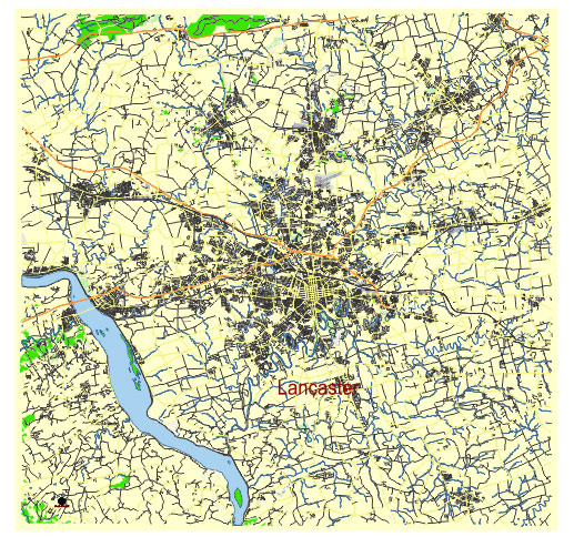
Principal streets and roads, names places, residential streets and roads, road number labels, water objects, land use areas.
Lancaster Pennsylvania US editable vector map svg free
DOWNLOAD ARCHIVE FOR FREE >>>
Distributed with Creative Commons Attribution 4.0 International License
SEE ALSO FULL VERSION OF THE Lancaster Pennsylvania US vector map (Adobe Illustrator, PDF etc.)
Lancaster, Pennsylvania, is a historic city with a well-defined structure of streets, roads, and districts. Here’s an overview:
Principal Streets and Roads
- King Street (PA-462): One of the main east-west thoroughfares in the city.
- Queen Street (PA-72): Runs north-south through downtown Lancaster.
- Duke Street: Parallel to Queen Street, another significant north-south route.
- Orange Street: An important east-west street in downtown.
- Lime Street: A key north-south route on the eastern side of the city.
- Prince Street (PA-222): A major north-south road.
- Chestnut Street: Another major east-west street, often used to navigate downtown.
- Walnut Street: Parallel to Chestnut Street and also significant for local traffic.
- Lititz Pike (PA-501): A crucial road running north from Lancaster to Lititz.
- Harrisburg Pike: Connects the city to the western suburbs and beyond.
- Manheim Pike (PA-72): A major road leading to the northwest suburbs.
- Columbia Avenue (PA-462): Runs west from downtown, connecting Lancaster with Columbia.
- New Holland Avenue (PA-23): An important route running northeast from the city center.
Notable City Districts
- Downtown Lancaster: The heart of the city, with historic buildings, Central Market, and a variety of shops, restaurants, and cultural venues.
- West End: Known for its residential neighborhoods and proximity to Franklin & Marshall College.
- Chestnut Hill: A residential area with a mix of historic homes and modern amenities.
- Cabbage Hill: Also known as the “Hill,” a historic working-class neighborhood.
- Northeast Lancaster: Primarily residential with several parks and schools.
- Southeast Lancaster: A diverse area with a mix of residential and commercial properties.
- College Park: Surrounding Franklin & Marshall College, with many student residences and college facilities.
- Lancaster Township: A suburban area with a mix of residential, commercial, and industrial properties.
- Ross Neighborhood: A historic district with charming old homes and tree-lined streets.
- Musselman-Vesta Iron Furnace Center: Located along the Conestoga River, reflecting the city’s industrial past.
These streets and districts form the backbone of Lancaster, creating a rich tapestry of historic charm and modern living.
 Author: Kirill Shrayber, Ph.D. FRGS