Editable Vector Map of the Kansas City Missouri US in SVG format.
Can be edited in the following programs: Adobe Illustrator, CorelDraw, InkScape
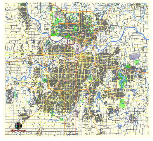
Principal streets and roads, names places, residential streets and roads, road number labels, water objects, land use areas.
Kansas City Missouri US editable vector map svg free
DOWNLOAD ARCHIVE FOR FREE >>>
Distributed with Creative Commons Attribution 4.0 International License
SEE ALSO FULL VERSION OF THE Kansas City Missouri US vector map (Adobe Illustrator, PDF etc.)
Kansas City, Missouri, is known for its distinct neighborhoods, vibrant streets, and iconic landmarks. Here’s an overview of some principal streets, roads, and city districts:
- Downtown Kansas City: This area encompasses the central business district and is home to many corporate headquarters, cultural attractions, and entertainment venues. Key streets include Main Street, Grand Boulevard, and Broadway Boulevard.
- Country Club Plaza: Often referred to simply as “The Plaza,” this upscale shopping and entertainment district is known for its Spanish-inspired architecture, fountains, and boutiques. The main thoroughfare is Ward Parkway, with Nichols Road being another prominent street.
- Westport: Historically significant as a stop on the Oregon Trail, Westport has evolved into a bustling entertainment district with a mix of bars, restaurants, and shops. Westport Road and Pennsylvania Avenue are major streets in this area.
- Crossroads Arts District: As the name suggests, this neighborhood is known for its art galleries, studios, and creative spaces. Main Street and Southwest Boulevard are primary arteries running through this area.
- Power & Light District: Developed as a major entertainment area, this district features restaurants, bars, and live music venues. It’s located near the Sprint Center and the Kansas City Convention Center, with Grand Boulevard and 13th Street as main thoroughfares.
- River Market: Situated along the Missouri River, this historic district is known for its farmers’ market, eclectic shops, and diverse dining options. Main Street and Delaware Street are central to this area.
- 18th & Vine: Recognized as the historic center of Kansas City’s African American community and jazz heritage, this district is home to the American Jazz Museum and the Negro Leagues Baseball Museum. 18th Street and Vine Street are the primary roads here.
- Midtown: This area covers a broad swath of the city and includes diverse neighborhoods like Midtown-Westport, Hyde Park, and Southmoreland. Key streets include Troost Avenue, Linwood Boulevard, and Armour Boulevard.
- Brookside: Known for its charming homes, boutique shops, and tree-lined streets, Brookside is a residential area with a distinct commercial district along 63rd Street.
- Crown Center: Developed by the Hallmark Cards company, Crown Center is a mixed-use complex featuring shopping, dining, and entertainment options. Grand Boulevard and Pershing Road are central to this area.
These are just a few of the many neighborhoods and districts that make up the fabric of Kansas City, Missouri, each with its own unique character and attractions.
 Author: Kirill Shrayber, Ph.D. FRGS