Editable Vector Map of the Gatineau Quebec Canada in SVG format.
Can be edited in the following programs: Adobe Illustrator, CorelDraw, InkScape
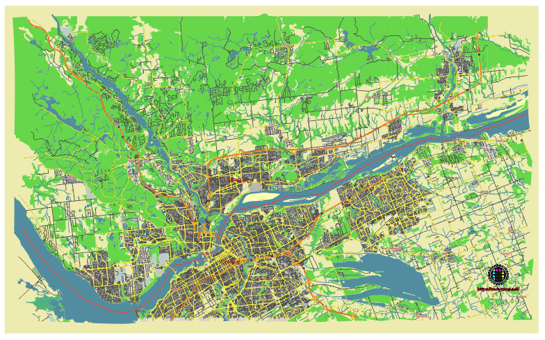
Principal streets and roads, names places, residential streets and roads, road number labels, water objects, land use areas.
Gatineau Quebec Canada editable vector map svg free
DOWNLOAD ARCHIVE FOR FREE >>>
Distributed with Creative Commons Attribution 4.0 International License
SEE ALSO FULL VERSION OF THE Gatineau Quebec Canada vector map (Adobe Illustrator, PDF etc.)
Gatineau, Quebec, is a vibrant city located in the western part of the province, just across the river from Ottawa, Ontario. Here are the principal streets, roads, and city districts of Gatineau:
Principal Streets and Roads
- Boulevard des Allumettières: A major east-west thoroughfare that runs through the heart of Gatineau.
- Boulevard Saint-Joseph: One of the main commercial streets in Gatineau, known for its shops, restaurants, and businesses.
- Boulevard de la Gappe: Another important road that connects various residential and commercial areas.
- Boulevard Gréber: A significant north-south artery that is also a commercial hub.
- Boulevard Maloney: A major east-west road that serves the eastern parts of Gatineau, particularly the Gatineau sector.
- Autoroute 50: A key highway that runs through Gatineau, connecting it to other parts of Quebec and to Ontario.
- Rue Main: Located in the Aylmer district, this street is central to the area’s activities and amenities.
- Boulevard du Plateau: Located in the Plateau district, it is a newer commercial and residential area.
City Districts
- Hull: The historic downtown area of Gatineau, known for its government buildings, cultural institutions, and vibrant nightlife. Key landmarks include the Canadian Museum of History and the Casino du Lac-Leamy.
- Gatineau Sector: The largest and most populous sector, featuring residential neighborhoods, commercial zones, and recreational areas.
- Aylmer: Known for its historic charm, waterfront parks, and vibrant community life. It includes the Aylmer Marina and the British Hotel.
- Masson-Angers: A district located to the east of the main urban area, known for its more rural and suburban character.
- Buckingham: A historic district with a strong sense of community, featuring parks, schools, and local businesses.
- Plateau: A rapidly developing area known for its modern residential developments, shopping centers, and recreational facilities.
Each of these streets, roads, and districts contributes to the unique character and functionality of Gatineau, making it a dynamic part of the National Capital Region.
 Author: Kirill Shrayber, Ph.D. FRGS