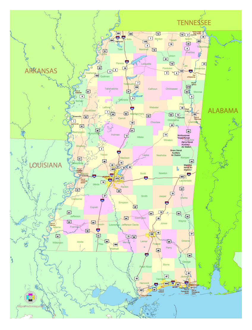
Free Vector map of the state of Mississippi, USA, main roads with numbers, colored counties with names.
Free, royalty-free, unlimited use.
The map is intended for editing, media, presentations.
File format SVG, PDF and Adobe Illustrator, Simplified version
Map in layers, fully vector, editable.
See also: detailed vector map of the state of Mississippi
Download vector map in archive:
https://vectormap.net/wp-content/uploads/free_maps_states_cities_2024/map_vector_us_state_mississippi_free_simple_ai.ai.zip
https://vectormap.net/wp-content/uploads/free_maps_states_cities_2024/map_vector_us_state_mississippi_free_simple_ai_pdf.pdf.zip
https://vectormap.net/wp-content/uploads/free_maps_states_cities_2024/map_vector_us_state_mississippi_free_simple_ai_svg.svg.zip

Free Vector map of the state of Mississippi, USA, main roads with numbers, colored counties with names.
Detailed Geographic Description of Mississippi with Main Cities
Mississippi, located in the southeastern United States, is characterized by its diverse topography, significant waterways, and cultural heritage. This description integrates its geographic features with an overview of its major cities and regions.
1. General Location and Borders
Mississippi is bordered by:
- North: Tennessee
- East: Alabama
- South: Gulf of Mexico and Louisiana
- West: Louisiana and Arkansas, with the Mississippi River forming the western boundary.
Mississippi spans approximately 48,430 square miles, making it the 32nd largest state by area. Its geographic center is near Carthage in Leake County.
2. Landforms
Mississippi is predominantly part of the Gulf Coastal Plain, with varied regions:
- Mississippi Delta:
- A flat, fertile alluvial plain along the Mississippi River, renowned for its cotton farming and cultural significance.
- Major cities: Greenville, Clarksdale, and Cleveland.
- North Central Hills:
- Rolling hills that transition from the Delta into higher ground.
- Major city: Oxford, home to the University of Mississippi.
- Northeastern Highlands (Tennessee Hills):
- Includes the Pontotoc Ridge and Tishomingo Hills, with slightly higher elevations.
- Major cities: Tupelo, birthplace of Elvis Presley.
- Pine Belt:
- Located in the southeastern part of the state, dominated by pine forests and sandy soils.
- Major city: Hattiesburg, an educational and economic hub.
- Coastal Plain:
- Southern Mississippi features flatlands and wetlands leading to the Gulf of Mexico.
- Major cities: Biloxi, Gulfport, and Pascagoula, which are central to the state’s tourism and maritime economy.
The highest point is Woodall Mountain (807 feet) in the northeastern part of the state, while the lowest is at sea level along the Gulf Coast.
3. Hydrology
Mississippi is named after the Mississippi River, a vital waterway for trade, agriculture, and recreation. Other significant rivers include:
- Pearl River: Flows past Jackson, the state capital.
- Big Black River: A tributary of the Mississippi River, draining the central region.
- Pascagoula River: Drains southeastern Mississippi into the Gulf of Mexico, notable for its undammed flow.
- Tombigbee River: Found in the northeast, part of the Tennessee-Tombigbee Waterway.
Lakes and reservoirs:
- Ross Barnett Reservoir (near Jackson): Recreation and water supply.
- Numerous oxbow lakes in the Delta, such as Lake Chicot.
4. Climate
Mississippi experiences a humid subtropical climate:
- Summers: Hot and humid, with temperatures often above 90°F (32°C).
- Winters: Mild, with temperatures ranging from 40°F to 60°F (4°C to 15°C).
- Rainfall: 50 to 65 inches annually, supporting lush vegetation.
- The state is prone to tornadoes in spring and hurricanes along the Gulf Coast.
5. Major Cities
a. Jackson (Capital and Largest City)
- Located near the Pearl River in central Mississippi.
- Serves as the political, economic, and cultural hub.
- Key landmarks: Mississippi State Capitol, Mississippi Civil Rights Museum, and Ross Barnett Reservoir.
b. Gulfport
- The second-largest city, situated on the Gulf Coast.
- A major port city with a robust seafood industry and beach tourism.
- Nearby attractions: Gulf Islands Waterpark and Ship Island.
c. Southaven
- Located near Memphis, Tennessee, in the northwest.
- A rapidly growing suburban city, part of the Memphis metropolitan area.
d. Hattiesburg
- Found in the Pine Belt region.
- Home to the University of Southern Mississippi and Camp Shelby (a major military training site).
e. Biloxi
- A coastal city known for its casinos, seafood industry, and cultural attractions.
- Nearby attractions: Biloxi Lighthouse and Gulf Islands National Seashore.
f. Tupelo
- Located in northeastern Mississippi.
- Famous as the birthplace of Elvis Presley.
g. Meridian
- Found in eastern Mississippi, near the Alabama border.
- Known for its historic railroads and the Mississippi Arts + Entertainment Experience.
h. Oxford
- Located in northern Mississippi.
- A cultural and educational hub, home to the University of Mississippi (Ole Miss).
i. Greenville
- In the heart of the Delta region.
- Known for its blues music heritage and proximity to the Mississippi River.
j. Pascagoula
- A Gulf Coast city with a strong shipbuilding industry.
6. Gulf Coast and Barrier Islands
Mississippi has approximately 44 miles of coastline along the Gulf of Mexico. The coastline features sandy beaches, estuaries, and barrier islands such as:
- Cat Island
- Ship Island
- Horn Island
These islands are part of the Gulf Islands National Seashore, offering habitats for diverse wildlife and recreational opportunities.
7. Economy and Land Use
- Agriculture: Dominated by cotton, soybeans, rice, and catfish farming, primarily in the Delta region.
- Forestry: The Pine Belt contributes to the timber industry.
- Tourism: Key areas include the Gulf Coast, historic Natchez, and Vicksburg.
- Industry: Shipbuilding in Pascagoula and manufacturing in urban centers.
Mississippi’s geography blends fertile agricultural plains, rolling hills, and scenic coastal landscapes, with its cities playing vital roles in commerce, culture, and tourism.

 Author: Kirill Shrayber, Ph.D. FRGS