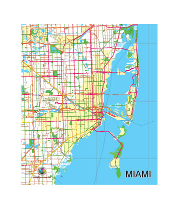
Free Vector map of the City of Miami, Florida, USA.
Free, royalty-free, unlimited use.
The map is intended for editing, media, presentations.
File format SVG, Simplified version
Fully vector, editable.
See also: detailed vector map of the Miami
Download vector map in archive:

Free Vector map of the City of Miami, Florida, USA.
The Miami area, located in southeastern Florida, is renowned for its vibrant urban core, diverse population, and tropical coastal environment. It encompasses the city of Miami as well as surrounding areas within Miami-Dade County. Known as a gateway to Latin America and the Caribbean, Miami is a major cultural, financial, and transportation hub. Below is a detailed geographic description of the Miami area:
General Location
- Region: Southeastern Florida, part of the South Florida region.
- Coordinates: Approximately 25°46′N 80°12′W.
- Proximity:
- About 30 miles south of Fort Lauderdale.
- 160 miles south of Orlando.
- 220 miles north of Key West (via U.S. Highway 1).
Urban Core
- City of Miami:
- Located on the Miami River, which flows from the Everglades into Biscayne Bay.
- Downtown Miami: The financial and cultural center, featuring skyscrapers, museums, and the Bayside Marketplace.
- Brickell: South of downtown, Miami’s financial district with luxury condos and offices.
- Wynwood: Known for its street art, galleries, and vibrant cultural scene.
- Little Havana: A historic Cuban-American neighborhood, famous for its Latin culture and Calle Ocho.
- Greater Miami:
- Includes cities like Miami Beach, Coral Gables, Hialeah, and Kendall.
- Miami Beach, located on barrier islands east of the city, is renowned for its Art Deco Historic District and vibrant nightlife.
Natural Features
- Waterways:
- Biscayne Bay: A shallow lagoon separating mainland Miami from barrier islands like Miami Beach.
- Miami River: Connects the Everglades watershed to Biscayne Bay.
- Numerous canals and waterways traverse the area, part of the South Florida Water Management District.
- Beaches and Coastline:
- South Beach: A world-famous beach in Miami Beach, known for its white sands and turquoise waters.
- Other notable beaches include Crandon Park Beach on Key Biscayne and Haulover Beach in North Miami.
- Topography:
- The area is predominantly flat, with elevations generally less than 10 feet above sea level.
- Miami’s location makes it vulnerable to flooding and sea-level rise.
- Parks and Natural Areas:
- Everglades National Park: A vast wetland ecosystem west of Miami, famous for its wildlife and airboat tours.
- Biscayne National Park: Protects coral reefs, mangroves, and the northern Florida Keys.
- Oleta River State Park: Florida’s largest urban park, offering kayaking, biking, and hiking.
Climate
- Type: Tropical monsoon climate (Köppen: Am).
- Seasons:
- Wet Season: May through October, characterized by high humidity, frequent thunderstorms, and average temperatures in the 80s°F.
- Dry Season: November through April, with milder, drier weather and temperatures in the 70s°F.
- Hurricane Risk: Miami lies within a hurricane-prone zone, with the peak season from August to October.
Transportation Geography
- Highways:
- Interstate 95 (I-95): Runs north-south through Miami, connecting it to Fort Lauderdale and beyond.
- State Road 836 (Dolphin Expressway): Connects Miami International Airport to downtown.
- U.S. Highway 1: A major north-south route extending to Key West.
- Public Transit:
- Metrorail: A 25-mile rapid transit system connecting central Miami to suburban areas.
- Metromover: A free downtown loop system serving Brickell, downtown, and the Arts District.
- Tri-Rail: A commuter rail linking Miami to Fort Lauderdale and West Palm Beach.
- Air and Sea:
- Miami International Airport (MIA): A major hub for domestic and international flights, especially to Latin America.
- PortMiami: The “Cruise Capital of the World,” handling millions of passengers annually.
Economic and Demographic Landscape
- Population: The city of Miami has about 450,000 residents, while the metro area has over 6 million.
- Economy: Driven by tourism, international trade, real estate, and financial services.
- Diversity: Miami is one of the most ethnically diverse cities in the U.S., with a significant Hispanic and Latin American population.
Recreational and Natural Attractions
- Cultural Sites:
- Vizcaya Museum and Gardens: A historic Italianate villa and estate.
- Pérez Art Museum Miami (PAMM): A contemporary art museum overlooking Biscayne Bay.
- Miami Design District: A hub for luxury shopping, dining, and art.
- Beaches and Islands:
- Key Biscayne: Features Crandon Park, Bill Baggs Cape Florida State Park, and views of the Atlantic Ocean.
- Virginia Key: Home to the Miami Seaquarium and scenic beaches.
- Events and Festivals:
- Art Basel Miami Beach: An international art fair held annually in December.
- Calle Ocho Festival: A major Hispanic cultural celebration in Little Havana.

 Author: Kirill Shrayber, Ph.D. FRGS