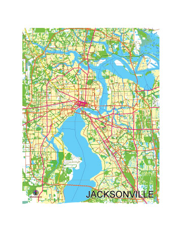
Free Vector map of the City of Jacksonville, Florida, USA.
Free, royalty-free, unlimited use.
The map is intended for editing, media, presentations.
File format SVG, Simplified version
Fully vector, editable.
See also: detailed vector map of the Jacksonville
Download vector map in archive:

Free Vector map of the City of Jacksonville, Florida, USA.
Jacksonville, located in the northeastern corner of Florida, is the largest city by land area in the contiguous United States. Situated along the St. Johns River and near the Atlantic coast, Jacksonville is a dynamic blend of urban life, suburban communities, natural landscapes, and coastal environments. Below is a detailed geographic description of the Jacksonville area:
General Location
- Region: Northeastern Florida.
- Coordinates: Approximately 30°20′N 81°39′W.
- Proximity:
- About 25 miles south of the Georgia border.
- 140 miles southeast of Tallahassee (Florida’s capital).
- 340 miles north of Miami.
Urban Core
- City of Jacksonville:
- Incorporated as a consolidated city-county government with Duval County in 1968, giving it vast land area and administrative reach.
- Downtown Jacksonville is the central business district, located on the north bank of the St. Johns River, featuring landmarks like the Bank of America Tower and the Main Street Bridge.
- Neighborhoods and Districts:
- Riverside and Avondale: Historic neighborhoods west of downtown, known for their early 20th-century architecture and the vibrant Five Points area.
- San Marco: South of downtown, offering a mix of historic charm, boutique shopping, and fine dining.
- Arlington: East of downtown, a suburban area with historical significance and access to natural parks.
- Mandarin: A picturesque area in southern Jacksonville, known for its tree-lined streets and proximity to the St. Johns River.
- Suburban and Regional Areas:
- Orange Park (Clay County): Southwest of Jacksonville, a rapidly growing suburban community.
- St. Johns County: South of the city, includes Ponte Vedra Beach and other affluent coastal communities.
- The Beaches: Jacksonville Beach, Neptune Beach, and Atlantic Beach form a coastal strip east of the city.
Natural Features
- Waterways:
- St. Johns River: One of the few north-flowing rivers in the U.S., it bisects the city and serves as a vital transportation and recreation corridor.
- Intracoastal Waterway: Runs parallel to the Atlantic coast, connecting to numerous waterways and inlets.
- Numerous creeks, tributaries, and estuaries make the region a hub for boating and fishing.
- Coastline and Beaches:
- Approximately 22 miles of sandy beaches, including Jacksonville Beach, Atlantic Beach, and Neptune Beach.
- Little Talbot Island State Park and Big Talbot Island State Park: Unspoiled barrier islands with beaches and unique geological features like “boneyard beaches.”
- Parks and Preserves:
- Timucuan Ecological and Historic Preserve: A 46,000-acre preserve protecting wetlands, salt marshes, and historical sites like Fort Caroline.
- Kathryn Abbey Hanna Park: Offers trails, camping, and a popular surf beach.
- Huguenot Memorial Park: A peninsula offering waterfront recreation on the Atlantic and the St. Johns River.
- Topography:
- Mostly flat and low-lying, with elevations ranging from sea level to about 40 feet above.
- Marshlands and tidal estuaries dominate coastal areas.
Climate
- Type: Humid subtropical.
- Seasons:
- Summer: Hot, humid, with temperatures in the 90s°F and frequent afternoon thunderstorms.
- Winter: Mild, with highs in the 60s°F and occasional dips into the 40s°F.
- Rainfall: Peaks in summer, with June to September being the wettest months.
- Hurricane Risk: Vulnerable to tropical storms and hurricanes during the Atlantic hurricane season (June to November).
Transportation Geography
- Highways:
- Interstate 95 (I-95): A major north-south route through the city.
- Interstate 10 (I-10): Begins in Jacksonville and runs westward to Los Angeles.
- State Road 9A (I-295 Beltway): A loop around Jacksonville for regional connectivity.
- Bridges:
- Notable bridges over the St. Johns River include the Dames Point Bridge, Main Street Bridge, and Fuller Warren Bridge.
- Port and Maritime:
- Port of Jacksonville (JAXPORT): A major deep-water port handling containerized cargo and cruise operations.
- A hub for naval operations, with the Naval Station Mayport and Naval Air Station Jacksonville.
- Airports:
- Jacksonville International Airport (JAX): Located north of downtown, serving domestic and limited international flights.
- Public Transit:
- The Jacksonville Transportation Authority (JTA) provides buses, a downtown Skyway monorail, and express commuter services.
Economic and Demographic Landscape
- Population: Approximately 970,000 in Jacksonville; over 1.6 million in the metropolitan area.
- Economy:
- Diversified, with strengths in banking, logistics, healthcare, and military.
- Growing technology and innovation sectors.
- Diversity: A blend of urban, suburban, and rural communities, with significant African American, Hispanic, and Asian populations.
Recreational and Cultural Attractions
- Sports:
- Home to the NFL’s Jacksonville Jaguars, who play at TIAA Bank Field.
- Hosts the annual Florida-Georgia college football rivalry and the Gator Bowl.
- Cultural Sites:
- Cummer Museum of Art and Gardens: A historic art museum with riverside gardens.
- Museum of Science and History (MOSH): Offers interactive exhibits on science, history, and innovation.
- Festivals and Events:
- Jacksonville Jazz Festival: A prominent annual music event.
- The Players Championship (TPC Sawgrass): A prestigious PGA Tour event held nearby in Ponte Vedra Beach.
- Outdoor Activities:
- Boating, kayaking, and fishing are popular along the St. Johns River and the Intracoastal Waterway.
- Hiking and bird-watching in the region’s many parks and preserves.

 Author: Kirill Shrayber, Ph.D. FRGS