Editable Vector Map of the East Bay (east part of San Francisco Bay Area) California US in Adobe Illustrator, PDF and SVG Free.
Can be edited in the following programs: Adobe Illustrator, CorelDraw, InkScape
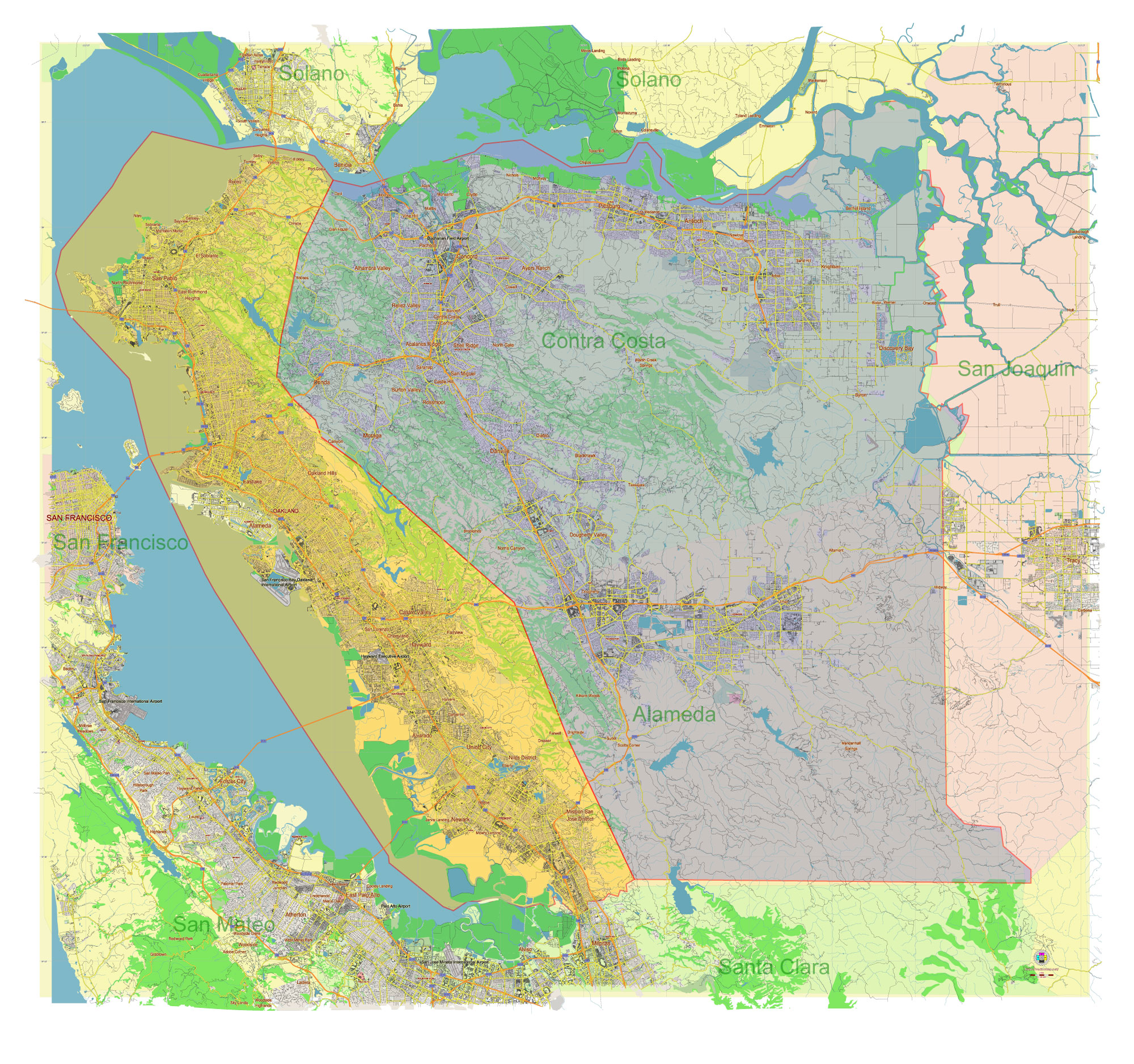
Principal streets and roads, names places, residential streets and roads, road number labels, water objects, land use areas.
East Bay (east part of San Francisco Bay Area) California US Vector Map in Adobe Illustrator, PDF and SVG Free
East Bay (east part of San Francisco Bay Area) California US editable vector map SVG free DOWNLOAD ARCHIVE FOR FREE 14 mb >>>
East Bay (east part of San Francisco Bay Area) California US editable vector map Adobe Illustrator free DOWNLOAD ARCHIVE FOR FREE 23 mb >>>
East Bay (east part of San Francisco Bay Area) California US editable vector map PDF free DOWNLOAD ARCHIVE FOR FREE 43 mb >>>
Distributed with Creative Commons CC-Zero = Creative Commons CC0 1.0 Universal Public Domain Dedication International License
SEE ALSO FULL VERSION OF THE California State vector map (Adobe Illustrator, PDF etc.)
The East Bay region of the San Francisco Bay Area in California includes several cities and towns, each with its own distinct character. Here are some of the principal streets, roads, and notable cities and towns in the East Bay:
Principal Streets and Roads
- Interstate 880 (I-880): Also known as the Nimitz Freeway, this major north-south highway runs through Oakland, Hayward, and Fremont, connecting the East Bay with Silicon Valley.
- Interstate 580 (I-580): This east-west freeway connects the East Bay to the Central Valley and traverses through cities like Oakland, Castro Valley, and Livermore.
- Interstate 80 (I-80): Running through Berkeley, Albany, and Richmond, this interstate is a key route for travel between the East Bay and Sacramento.
- State Route 24 (CA-24): Connecting Oakland to the cities of the Lamorinda area (Lafayette, Moraga, Orinda), it is a crucial east-west route.
- State Route 13 (CA-13): Also known as the Warren Freeway, it runs through Oakland and Berkeley, providing access to residential areas.
- State Route 4 (CA-4): Serving the northern part of the East Bay, this route runs through cities like Hercules, Martinez, and Antioch.
- Mission Boulevard: A major arterial road running through Fremont, Union City, and Hayward.
- San Pablo Avenue: A historic north-south route that runs through multiple cities, including Oakland, Emeryville, Berkeley, Albany, and Richmond.
Notable Cities and Towns
- Oakland: The largest city in the East Bay, known for its vibrant arts scene, diverse culture, and significant port.
- Berkeley: Home to the University of California, Berkeley, this city is renowned for its academic and cultural influence.
- Fremont: A major suburban city known for its technology sector and proximity to Silicon Valley.
- Hayward: Known as the “Heart of the Bay,” Hayward is a diverse city with a mix of residential, commercial, and industrial areas.
- Richmond: Located along the waterfront, Richmond has a rich industrial history and is home to the Rosie the Riveter WWII Home Front National Historical Park.
- Concord: The largest city in Contra Costa County, known for its suburban feel and the Concord Pavilion, a major concert venue.
- Walnut Creek: A vibrant suburban city known for its shopping, dining, and excellent public schools.
- San Leandro: A suburban city with a significant industrial sector and a growing tech industry presence.
- Pleasanton: Known for its historic downtown, family-friendly atmosphere, and as the headquarters for several major corporations.
- Dublin: A rapidly growing suburban city with a mix of residential and commercial developments.
- Livermore: Known for its wineries and the Lawrence Livermore National Laboratory.
- Martinez: The county seat of Contra Costa County, known for its historic downtown and waterfront.
These cities and roads are crucial to the infrastructure and daily life in the East Bay, making it a dynamic and diverse region within the San Francisco Bay Area.
 Author: Kirill Shrayber, Ph.D. FRGS